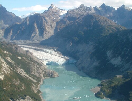
Glacier Bay National Park and Preserve
58.7000° N · 137.0000° W · National Park
Photo: Janquen at English Wikipedia · CC BY-SA 3.0 · Wikimedia Commons
Glacier Bay National Park and Preserve is a national park of the United States. Vancouver found the bay almost entirely filled with ice in 1794. The free Lokali audio guide runs 8 minutes.
✓ Published October 2026 · how we write these guides
Visitor facts
| Lokali audio guide | 8 min · free |
|---|---|
| Type | National Park |
| Location | Alaska, United States |
| Coordinates | 58.7000, -137.0000 |
| Official website | nps.gov |
| Languages | 50+, in the Lokali app |
The story
Listen first. Out on the water, the air is cold and very still, and then a long crack rolls across the bay like distant thunder. Somewhere ahead, a wall of ice is shifting. A moment later, a slab the size of a building leans forward and drops into the sea. The splash comes before the sound reaches you, and the waves arrive last. This is Glacier Bay, in the far southeast of Alaska, and that sequence of crack, splash and swell is how the place has been shaping itself for centuries.
Now look at the landscape around you and try to picture it covered in ice. When the British navigator George Vancouver sailed past this coast in 1794, there was almost no bay at all. His crew saw a solid face of ice standing near the entrance, close to Icy Strait. Behind it, a glacier thousands of feet thick filled the whole valley. The water you may be floating on today was buried under that ice. It is one of the most dramatic changes on a map anywhere in the modern era.
Here is the first surprise. Since Vancouver's visit, the ice has pulled back more than sixty miles, roughly one hundred kilometres. That is one of the fastest glacial retreats ever recorded. A bay that did not exist on his chart now runs deep into the mountains, with arms that branch off into smaller inlets. Each of those inlets was uncovered within the last two hundred and fifty years or so. In geological terms, the land around you is brand new.
Long before any European ship arrived, this was the homeland of the Huna Tlingit people, one of the Indigenous nations of Alaska's southeast coast. Their oral history tells of a time when the glacier advanced and forced their ancestors to leave their villages in the bay. According to one traditional account, the ice came forward faster than a running dog. The families moved across the water to the area around present-day Hoonah, but their ties to Glacier Bay never ended. Many Huna Tlingit still describe this place simply as home.
In 1879, the naturalist John Muir came here by canoe with Tlingit guides. Muir was a Scottish-born American writer who later helped inspire the national park movement in the United States. He wrote about the glaciers with great excitement, and his descriptions drew the first tourist steamships north. A glacier in the park still carries his name, although Muir Glacier has retreated so far that it no longer reaches the sea. Muir's writing turned a remote fjord into a destination, and visitors have followed his route ever since.
The area became a national monument in 1925, and a full national park and preserve in 1980. It is also part of a large UNESCO World Heritage Site that crosses the border into Canada. Together, these protected lands form one of the largest intact wilderness areas on the planet. There are almost no roads here. Most people arrive by ship, and many see the park without ever setting foot on land. National Park Service rangers often board the cruise ships to narrate the journey up the bay.
If your ship or tour boat travels up the western arm, you may reach Margerie Glacier. It is one of the most active tidewater glaciers in the park. A tidewater glacier is one that flows all the way down to the sea, so its front edge breaks off directly into the water. This breaking is called calving. Watch the face closely. The deep blue patches are the oldest, densest ice. It looks blue because thick ice absorbs the red end of the light and lets the blue pass through.
Next to Margerie sits the Grand Pacific Glacier, and it can look strangely dark. That darkness is rock and gravel carried inside the ice, ground down from the mountains as the glacier moves. From a distance, many visitors mistake it for a dirty hillside. Here is the second surprise. The Grand Pacific begins high in the mountains in Canada, across the international border. The ice in front of you may have started its slow journey in another country, long before anyone on your boat was born.
As you travel back toward the mouth of the bay, pay attention to the plants. Near the glaciers, the rock is bare or covered in thin moss. Farther down the bay, you see low shrubs, then willow and alder, then young spruce. Near the entrance, around Bartlett Cove, there is a mature forest of tall spruce and hemlock. Because the ice retreated in stages, the bay works like a living timeline. Scientists have studied this slow return of plants here for more than a century.
The water is just as full of life. Cold, nutrient-rich currents bring food to the bay, and the animals follow. Humpback whales come here to feed in the summer months, and you may see a tail rise and slide under the surface. Steller sea lions gather on the rocks of South Marble Island, and their barking carries across the water. Look up at the steep cliffs too. Pale dots that seem to move are often mountain goats, standing on ledges that look impossible to reach.
On land, the main visitor area is at Bartlett Cove, near the small community of Gustavus. Here the forest is quiet and damp, and the paths are soft with moss and needles. The smell is wet earth and spruce. Close to the shore stands a Huna Tlingit tribal house, built in recent years as a gathering place for the clan families of Glacier Bay. Its carved and painted panels connect the present-day community with the homeland that the ice once took from them.
Weather shapes every visit here. Low clouds can hide the peaks for hours, and then lift suddenly to show snowfields high above the water. On a clear day, you may see Mount Fairweather, one of the tallest coastal mountains in North America, standing white against the sky. Rain is common, and fog can drift across the bay in minutes. None of this spoils the experience. The changing light is part of the place, and the grey days often make the blue ice look even deeper.
So take one more moment where you are. Feel the cold air coming off the ice, and notice how quiet the bay becomes between each crack and rumble. The glacier in front of you is still moving, still shaping this coastline, as it has done for centuries. When you turn away, keep listening. Another piece of ice may fall behind you, and the waves will reach your boat a little later... a small reminder that this landscape is never finished.
Key facts
What to look for
Practical tips
Common questions
Is there a free audio guide to Glacier Bay National Park and Preserve?
Yes — the Lokali app narrates Glacier Bay National Park and Preserve free of charge in 50+ languages. The guide runs about 8 minutes, covers the history, what to look for on site and practical tips, and works offline once downloaded.
Where is Glacier Bay National Park and Preserve?
Glacier Bay National Park and Preserve is near Alaska, United States, at 58.7000, -137.0000. Tap the map link on this page for directions from where you are.
What is Glacier Bay National Park and Preserve known for?
Vancouver found the bay almost entirely filled with ice in 1794. Glaciers here have retreated more than sixty miles since then.
What should you look for at Glacier Bay National Park and Preserve?
Deep blue streaks in the ice face of Margerie Glacier. Dark rock-covered surface of the Grand Pacific Glacier. Pale mountain goats on steep cliffs above the water.
What should you know before visiting Glacier Bay National Park and Preserve?
Bring waterproof layers, gloves and a hat, even in summer. Carry binoculars to spot goats and sea lions on distant cliffs.
When is the best time to visit Glacier Bay National Park and Preserve?
Bring waterproof layers, gloves and a hat, even in summer.
On the map
Opens directions to Glacier Bay National Park and Preserve from your location.
Hear Glacier Bay National Park and Preserve in your language
The full story, narrated, in 50+ languages. Download it before you go and it plays offline, at your own pace, with no ticket and no tour group.