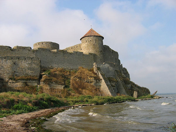
Bilhorod-Dnistrovskyi Fortress
46.2006° N · 30.3507° E · Castle
Photo: Ірина Пустиннікова · CC BY-SA 3.0 · Wikimedia Commons
Bilhorod-Dnistrovskyi Fortress is a fortress in Ukraine. Ancient Greek city of Tyras stood on this site. The free Lokali audio guide runs 7 minutes.
✓ Published October 2026 · how we write these guides
Visitor facts
| Lokali audio guide | 7 min · free |
|---|---|
| Type | Castle |
| Location | Bilhorod-Dnistrovskyi, Ukraine |
| Coordinates | 46.2006, 30.3507 |
| Languages | 50+, in the Lokali app |
The story
Listen first. Wind comes off the water and moves through the gaps in the stone. Somewhere a gull calls. Under your feet the ground is uneven, packed earth and old rubble softened by grass. In front of you a long grey wall runs along the edge of a wide, shallow body of water. That water is the Dniester estuary, where one of Europe's great rivers slows down before it reaches the Black Sea. You are standing beside the Bilhorod-Dnistrovskyi fortress, one of the largest medieval strongholds in Ukraine.
Before we walk anywhere, think about the name of this town. Bilhorod means white city. The Romanians called this place Cetatea Albă, which means white fortress. The Ottoman Turks called it Akkerman, and that also means white fortress. Italian merchants used a name that pointed in a different direction, Maurocastro, the black castle. So many peoples came here, and almost every one of them named the place by its colour. The fortress you see today is mostly grey and ochre, but in bright sun the pale stone still catches the light.
The story of this shore is much older than the walls. In ancient times, Greek colonists from the Aegean world settled here and founded a city called Tyras. The Greeks used the same name for the river itself. Tyras was a trading town. Grain, fish and goods moved between the steppe and the wider Mediterranean world. Archaeologists have excavated parts of the ancient city close to the fortress walls. So when you look at this ground, you are looking at layers... Greek, then Roman, then medieval, one on top of another.
The stronghold that stands here now took shape mainly in the fourteenth and fifteenth centuries. In that period, this coast belonged to the Principality of Moldavia, a medieval state to the west, roughly where Moldova and northeastern Romania are today. For Moldavia, this was the key to the sea. Whoever held the mouth of the Dniester controlled a major trade route between the Black Sea and the lands of central Europe. Genoese traders from Italy were also active along this coast, and their ships knew this harbour well.
Look now at the shape of the walls. They do not form a neat square. They follow the land, bending along the edge of the estuary and the high ground. On the land side, a deep ditch runs in front of the wall. In its working days, this moat was a serious obstacle for any army. The outer walls stretch for well over a kilometre, and inside them is enough space for a small town. Soldiers, merchants, animals and supplies could all shelter here during a siege.
The defences work in layers. First comes the ditch. Then the outer wall with its towers. Inside, the space divides into separate courtyards, each one able to hold out on its own. At the heart sits the citadel, the innermost fortress, with its own tall corner towers. An attacker who broke through one wall still faced another. This was the logic of late medieval military building... make every step cost the enemy more time, more men and more blood.
Here is something many visitors miss. Look closely at the towers and the gateways. Some are round, some are square, and the masonry changes from section to section. That is not careless building. It shows how the fortress grew over generations. Each ruler repaired, extended and thickened the walls as weapons changed. When cannons arrived, thin high walls became dangerous, and builders responded with heavier, lower defences. The stone carries a record of that arms race.
In 1484, the fortress fell to the Ottoman Empire under Sultan Bayezid the Second. It was a heavy loss for Moldavia, whose ruler, Stephen the Great, had worked hard to strengthen this coast. Under the Ottomans, the town became Akkerman and served as an important military and trading base on the northern shore of the Black Sea. For more than three centuries, the call to prayer sounded here, and the fortress guarded Ottoman interests against rivals to the north.
In the early nineteenth century, the region passed to the Russian Empire, along with the wider territory known as Bessarabia. Later, between the two world wars, the town belonged to Romania. After the Second World War, it became part of Soviet Ukraine, and today it lies within independent Ukraine, in the Odesa region. Few places in Europe have changed hands so many times. The walls stayed in place while the flags above them changed again and again.
Now for a lighter detail. Locals like to tell visitors that the Roman poet Ovid lived his exile here, and one of the towers carries his name in popular tradition. Historians place Ovid's exile further south, at Tomis, the city now called Constanța on the Romanian coast. So treat the Ovid story as a local legend, not documented history. Still, it shows how strongly people here want to connect their fortress to the ancient world.
The second surprise comes from the cinema. During the Soviet period, film crews found these walls very useful. Here was a real medieval fortress, mostly intact, with water on one side and open sky above. Several Soviet adventure films about knights and outlaws were shot here. If you have ever watched an old Soviet knight film, there is a fair chance you have already seen these towers on screen without knowing where they were.
As you walk, slow down at the walls that face the water. From here, the estuary looks almost like a calm sea, wide and pale. Small boats sometimes move across it, and fishermen work along the shore. On a windy day, you can hear the water slap against the stones below. This view explains the fortress better than any map. Every ship that wanted to reach the river had to pass in front of these walls.
Take a moment before you leave. Run your hand along the rough stone if you can reach it. Look up at the nearest tower and notice the patches of newer and older masonry side by side. Listen again to the wind and the gulls. Greek traders, Moldavian soldiers, Ottoman garrisons and film crews all stood near this spot. Now it is your turn. As you walk back through the gate, glance once more at the water, and remember why so many people wanted to hold this white fortress.
Key facts
What to look for
Practical tips
Common questions
Is there a free audio guide to Bilhorod-Dnistrovskyi Fortress?
Yes — the Lokali app narrates Bilhorod-Dnistrovskyi Fortress free of charge in 50+ languages. The guide runs about 7 minutes, covers the history, what to look for on site and practical tips, and works offline once downloaded.
Where is Bilhorod-Dnistrovskyi Fortress?
Bilhorod-Dnistrovskyi Fortress is in Bilhorod-Dnistrovskyi, Ukraine, at 46.2006, 30.3507. Tap the map link on this page for directions from where you are.
What is Bilhorod-Dnistrovskyi Fortress known for?
Ancient Greek city of Tyras stood on this site. Main fortress built in fourteenth and fifteenth centuries.
What should you look for at Bilhorod-Dnistrovskyi Fortress?
The deep defensive ditch along the land side. Round and square towers built in different periods. Patches of mismatched masonry from centuries of repair.
What should you know before visiting Bilhorod-Dnistrovskyi Fortress?
Walk the walls facing the estuary for the widest views. Wear sturdy shoes for uneven ground and rubble.
When is the best time to visit Bilhorod-Dnistrovskyi Fortress?
Bring water and sun protection on summer days.
On the map
Opens directions to Bilhorod-Dnistrovskyi Fortress from your location.
More to see near Bilhorod-Dnistrovskyi Fortress

Hear Bilhorod-Dnistrovskyi Fortress in your language
The full story, narrated, in 50+ languages. Download it before you go and it plays offline, at your own pace, with no ticket and no tour group.