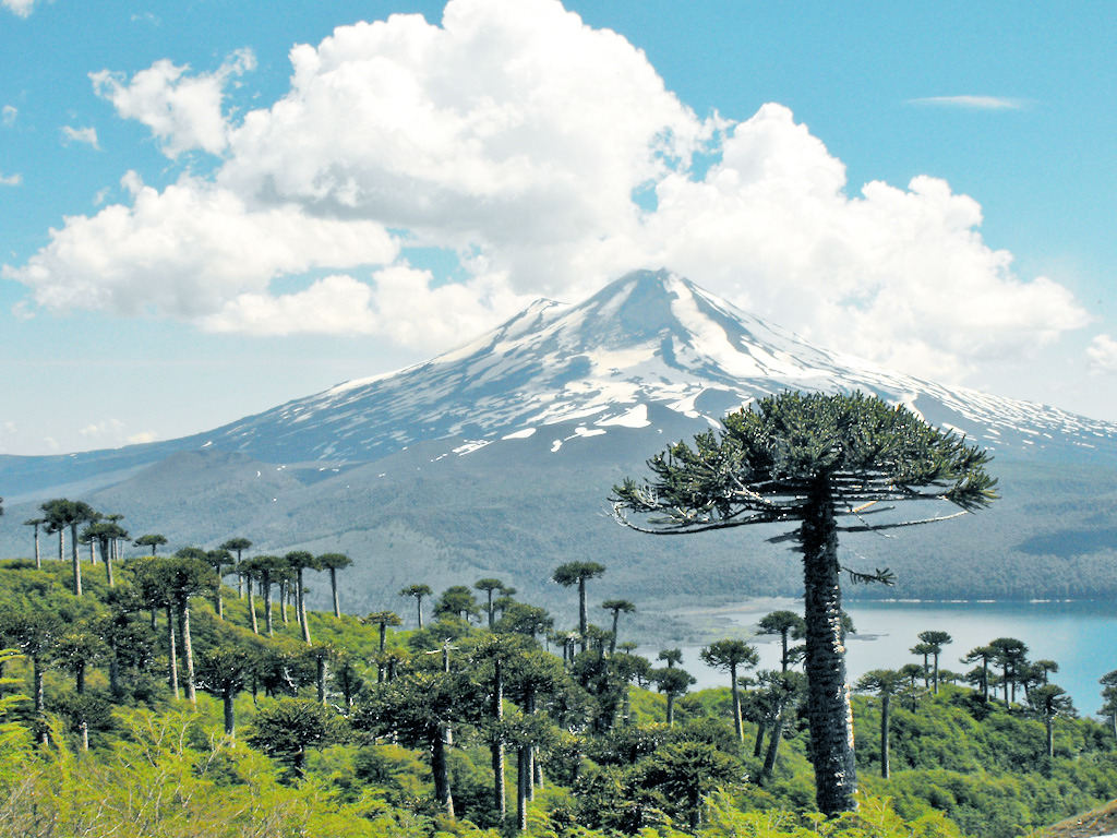
Conguillío National Park
38.6667° S · 71.6500° W · National Park
Photo: lautaroj · CC BY 2.0 · Wikimedia Commons
Conguillío National Park is a national park in Chile. Llaima is one of Chile's most active volcanoes. The free Lokali audio guide runs 6 minutes.
✓ Published October 2026 · how we write these guides
Visitor facts
| Lokali audio guide | 6 min · free |
|---|---|
| Type | National Park |
| Location | Cautín, Chile |
| Coordinates | -38.6667, -71.6500 |
| Languages | 50+, in the Lokali app |
The story
Listen to the ground under your boots. It does not crunch like gravel or soften like soil. It grinds. This is volcanic scoria, black and rust-red, broken into small sharp pieces that shift with every step. Around you, the air smells of resin and cold stone. Ahead, tall trees with umbrella-shaped crowns stand against the sky. Behind them rises a snow-capped cone with a thin trail of vapour at its summit. Welcome to Conguillío National Park, in the Andes of southern Chile.
That cone is Llaima Volcano, and everything here begins with it. Llaima is one of the most active volcanoes in Chile. It rises more than three thousand metres above sea level, and it has erupted many times in recorded history. One of its recent eruptions came in 2008, when lava and ash closed parts of the park. The volcano is not a backdrop. It is the main architect of this landscape, and its work is still going on.
Look at the black fields that spread across the valley floor. These are old lava flows. Some look almost fresh, with ridges and folds like poured dark syrup that froze in place. Others already carry lichens, mosses and small shrubs. You are looking at a timeline written in rock. The bare flows are younger. The green ones are older. Plants move into lava very slowly, so a single patch of moss here may represent many years of patient growth.
Now turn to the trees. These are araucarias, known in English as monkey puzzle trees. Their branches grow in neat whorls, and their leaves are stiff, overlapping scales with sharp points. Touch one carefully and you will understand the English name. Araucarias are an ancient lineage of conifers, related to trees that grew in the age of the dinosaurs. They grow slowly, and the largest specimens are believed to be many centuries old.
Here is something many visitors miss. Look closely at the bark of an old araucaria. It is very thick and broken into plates, almost like armour. This is not decoration. Thick bark helps the tree survive heat from fire and, scientists believe, from volcanic events. In a place where the mountain regularly sends fire and ash down its slopes, the trees that last are the trees that can take a hit.
For the Mapuche people, the Indigenous people of this region, the araucaria is far more than a tree. They call it pehuén. Its large seeds, called piñones, have been an important food for generations, especially for the Pehuenche, a Mapuche group whose name is often translated as people of the pehuén. In autumn, families still gather the seeds. They are boiled or roasted, and they taste a little like chestnuts.
The name Conguillío itself comes from Mapudungun, the Mapuche language. It is commonly explained as referring to piñones in the water, which ties the park's name directly to these trees and this lake. As with many place names, you will hear slightly different translations. But almost every version returns to the same image. Seeds of the pehuén, falling into clear mountain water.
That water is Lake Conguillío, the largest lake in the park. Its colour changes through the day, from deep blue to pale green. Many lakes in this area formed when lava flows blocked old valleys and streams. The water collected behind the new rock walls. So the lake you see is, in a way, a gift from the volcano. The same force that burns the forest also creates the water that feeds it.
Nearby are smaller lagoons with another surprise. In some of them, you can see dead tree trunks standing upright in the water. They are not fallen logs. They are trees that once grew on dry ground, before lava changed the drainage and the water rose around them. The cold, clear water has kept many of them standing. On a calm day, their grey trunks and their reflections make a quiet, strange picture.
If you have time and energy, the park has trails for many levels. Short paths lead to lagoons and viewpoints. A longer and well-known trail, Sierra Nevada, climbs through araucaria and southern beech forest toward views of the lake and the volcano. The beech trees, called coigüe and lenga, give the lower forest its colour. In autumn, the lenga turns orange and red, a sharp contrast to the dark green araucarias.
Listen for birds as you walk. The forest is often quiet, which makes each sound stand out. You may hear a hard, rhythmic knocking from high in the trees. This could be the Magellanic woodpecker, a large black woodpecker of southern Chile and Argentina. The male has a bright red head. Parrots also visit these forests, and you may hear their noisy calls before you see the flash of green.
The weather here changes quickly. A clear morning can turn grey by noon, and clouds can hide the summit of Llaima for hours. Snow covers the higher parts of the park in winter, and some roads may close. Rangers watch the volcano carefully, and access can change when its activity increases. The mountain sets the rules here, and the park works around them. It is wise to check conditions before you head out.
Before you leave, stop for a moment. Look at the black stone at your feet, the scaled branches above you, and the white cone on the horizon. These three things belong together. The volcano makes the rock, the rock holds the lakes, and the araucarias grow slowly on top of it all. As you walk away, listen once more to that grinding sound under your boots. It is the sound of a young landscape, still being made.
Key facts
What to look for
Practical tips
Common questions
Is there a free audio guide to Conguillío National Park?
Yes — the Lokali app narrates Conguillío National Park free of charge in 50+ languages. The guide runs about 6 minutes, covers the history, what to look for on site and practical tips, and works offline once downloaded.
Where is Conguillío National Park?
Conguillío National Park is near Cautín, Chile, at -38.6667, -71.6500. Tap the map link on this page for directions from where you are.
What is Conguillío National Park known for?
Llaima is one of Chile's most active volcanoes. Llaima erupted in 2008, closing parts of the park.
What should you look for at Conguillío National Park?
Thick plated bark on the oldest araucaria trunks. Dead tree trunks standing upright in the lagoons. Black lava fields slowly covered by moss and lichen.
What should you know before visiting Conguillío National Park?
Wear sturdy boots for sharp, loose volcanic scoria. Bring warm layers because mountain weather changes fast.
When is the best time to visit Conguillío National Park?
Visit in autumn to see red lenga beside green araucarias.
On the map
Opens directions to Conguillío National Park from your location.
Hear Conguillío National Park in your language
The full story, narrated, in 50+ languages. Download it before you go and it plays offline, at your own pace, with no ticket and no tour group.