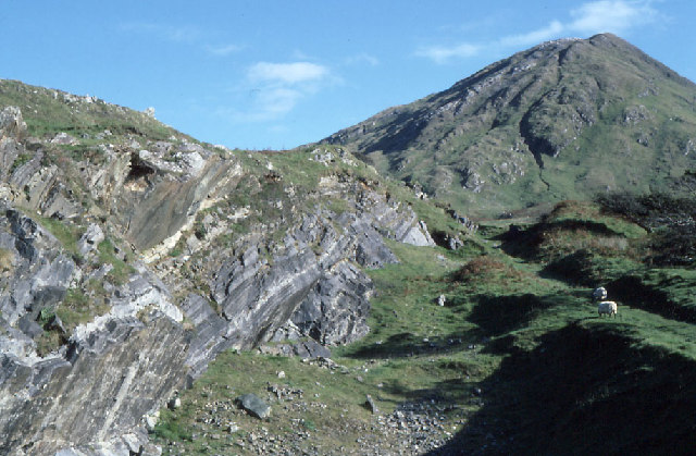
Connemara National Park
53.5511° N · 9.9447° W · National Park
Photo: Dr. Charles Nelson · CC BY-SA 2.0 · Wikimedia Commons
Connemara National Park is a national park. It is near County Galway, Ireland. Park opened to the public in 1980. The free Lokali audio guide runs 7 minutes.
✓ Published October 2026 · how we write these guides
Visitor facts
| Lokali audio guide | 7 min · free |
|---|---|
| Type | National Park |
| Location | County Galway, Ireland |
| Coordinates | 53.5511, -9.9447 |
| Official website | nationalparks.ie |
| Languages | 50+, in the Lokali app |
The story
Listen first. A wind moves across the open bog, low and steady, and under it you might hear water. It trickles somewhere beneath the heather, draining slowly downhill. The ground here gives a little under your boots, soft and springy, like a mattress soaked in rain. The air smells of wet earth and peat smoke from distant chimneys. Above you, the mountains rise in grey and green, and the light changes every few minutes as clouds race in from the Atlantic.
This is Connemara National Park, in the west of County Galway, close to the small village of Letterfrack. It covers almost 3,000 hectares of mountain, bog, heath and grassland. The park opened to the public in 1980, which makes it young as national parks go. But the land itself is very old. The rock under your feet formed hundreds of millions of years ago, long before Ireland had its present shape.
The mountains you can see belong to a range called the Twelve Bens. In Irish, the word for a peak is close to the English word ben. Several of these summits sit inside the park boundary, including Benbaun, Bencullagh, Benbrack and Muckanaght. Their upper slopes are made largely of quartzite, a very hard pale rock. After rain, the quartzite catches the light and shines almost silver. On bright days the peaks can look dusted with snow — even in summer.
Now look down at the ground near the path. Much of the park is blanket bog. That is a kind of wetland that spreads over the land like a cloth, formed over thousands of years in this cool, wet climate. Dead plants do not fully rot here. Instead they build up, layer upon layer, as peat. In places the peat runs several metres deep. For generations, local families cut this peat by hand, dried it in stacks, and burned it to heat their homes.
Here is something many visitors walk past without noticing. Among the mosses, look for tiny red plants with sticky hairs that glisten like dew. These are sundews, and they eat insects. The bog soil holds very few nutrients, so the plant traps small flies and digests them instead. Nearby you may find butterwort, another meat-eating plant, with pale green leaves shaped like a star. In early summer, white tufts of bog cotton nod in the wind across the wetter ground.
The land was not always empty. People have lived here for a very long time. Within the park there are megalithic tombs, stone burial sites roughly four thousand years old. You can also find traces of old field walls and the ruins of small stone houses from the nineteenth century. Those homes tell a quieter story. The Great Famine of the 1840s, and the hard decades that followed, emptied much of rural Connemara. Many families left and never came back.
The park also carries a more difficult chapter of modern Irish history. Some of its land once belonged to the Letterfrack Industrial School, run by a religious order for much of the twentieth century. Later investigations exposed serious abuse of the children held there. Other parts of the park once formed part of the Kylemore estate, home today to Kylemore Abbey. This mix of private estate, institution and farmland was gathered together, piece by piece, to create the park you are standing in.
Letterfrack itself has a story. The village grew up in the mid-nineteenth century when a Quaker family settled here. Quakers are a Christian group known for simple living and social work. They built homes, a school and other buildings, and tried to improve life for local people in the years after the Famine. Walk through the village after your visit, and you can still see the tidy layout of a planned settlement around a small crossroads.
The animals of the park are part of the experience. The park keeps a herd of Connemara ponies, a hardy local breed. They are small, strong and calm, built for rough ground and bad weather. You may also spot red deer, which disappeared from this region long ago and were later brought back. Listen for skylarks singing high overhead, and watch for stonechats perched on gorse bushes. Their call sounds like two small stones knocking together.
Most visitors come to walk. From the visitor centre, marked trails lead up and around Diamond Hill, the park's best-known climb. The lower loops are gentle, with gravel paths and boardwalks over the boggy ground. The upper trail climbs much more steeply to the summit. It rewards effort, but the weather can turn quickly. Mist can roll in and hide the path in minutes, so treat the mountain with respect.
From the top of Diamond Hill, the view opens in every direction. To the west, the Atlantic spreads out towards the islands, including Inishbofin on clear days. Below you sits Ballynakill Harbour, with its inlets cutting deep into the land. To the north you may see the grey outline of Kylemore Abbey beside its lake. Behind you, the Twelve Bens stand in a ragged line. On a still day you can hear sheep calling from valleys far below.
The weather is never a side note here. It shapes everything. Rain arrives from the ocean, clears, and returns, often within the same hour. A rainbow can appear over the bog and vanish before you find your camera. The light is soft and low much of the year, and it brings out colour in the land — rust-red grasses, purple heather in late summer, black pools of bog water reflecting the sky. Every visit looks a little different.
Before you leave, stop for a moment wherever you are. Feel the give of the ground underfoot. Look at the long, open slopes, and think of the people who cut turf, grazed sheep and built small stone homes on them. Then look up at the quartzite peaks, which were here long before any of them. As you walk back, listen for the water moving under the heather. It has been running through this bog for thousands of years, and it will keep running long after you are gone.
Key facts
What to look for
Practical tips
Common questions
Is there a free audio guide to Connemara National Park?
Yes — the Lokali app narrates Connemara National Park free of charge in 50+ languages. The guide runs about 7 minutes, covers the history, what to look for on site and practical tips, and works offline once downloaded.
Where is Connemara National Park?
Connemara National Park is near County Galway, Ireland, at 53.5511, -9.9447. Tap the map link on this page for directions from where you are.
What is Connemara National Park known for?
Park opened to the public in 1980. Covers almost 3,000 hectares near Letterfrack village.
What should you look for at Connemara National Park?
Sticky red sundews trapping insects among the mosses. Pale quartzite peaks shining silver after rain. Connemara ponies grazing in the lower fields.
What should you know before visiting Connemara National Park?
Pack waterproofs; Atlantic weather changes within minutes. Wear boots with grip for wet bog boardwalks.
On the map
Opens directions to Connemara National Park from your location.
More to see in County Galway


Hear Connemara National Park in your language
The full story, narrated, in 50+ languages. Download it before you go and it plays offline, at your own pace, with no ticket and no tour group.