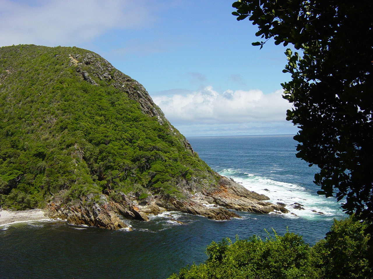
Tsitsikamma National Park
34.0217° S · 23.8956° E · National Park
Photo: Original uploader was Conrad88 at en.wikipedia · CC BY-SA 3.0 · Wikimedia Commons
Tsitsikamma National Park is a former national park in South Africa. Proclaimed a national park in 1964. The free Lokali audio guide runs 7 minutes.
✓ Published October 2026 · how we write these guides
Visitor facts
| Lokali audio guide | 7 min · free |
|---|---|
| Type | National Park |
| Location | Eastern Cape, South Africa |
| Coordinates | -34.0217, 23.8956 |
| Official website | sanparks.org |
| Languages | 50+, in the Lokali app |
The story
Listen first. Below the boardwalk, the Indian Ocean throws itself against dark rock, again and again. Each wave arrives with a deep thud and leaves with a long hiss of foam. The air tastes of salt. Behind you, the forest drips and rustles. Somewhere a bird calls with a hoarse, almost mechanical croak. You are standing on a narrow strip of land where mountain, forest and sea meet. That strip is the Tsitsikamma coast.
The name comes from the Khoekhoe language, spoken by some of the earliest people of this region. It is most often translated as something like a place of much water, or sparkling water. Linguists do not agree on one exact meaning. But stand here for a few minutes and the idea makes sense. Rivers cut down from the mountains. Waterfalls drop onto the beaches. Mist hangs in the trees. Water is everywhere.
Tsitsikamma became a national park in 1964. One part of that decision surprises many visitors. The park protected the sea as well as the land. A long stretch of ocean along this coast was set aside, and it became one of the first marine protected areas in Africa. So the rock pools, kelp and reef fish below you are part of the park. Today Tsitsikamma forms one section of the larger Garden Route National Park, created in 2009.
Look at the cliffs around you. They are made of hard, layered rock, mostly quartzite and sandstone, laid down as sediment hundreds of millions of years ago. Over time the land rose and the sea cut into it. The result is this coastline of steep drops and narrow gorges. The layers are tilted and folded. In some places they stand almost upright, like the pages of a giant book pushed on its side.
The most famous gorge in the park belongs to the Storms River. Here the river meets the ocean through a tight passage between high cliffs. A suspension bridge hangs across the river mouth, close to the water. Walking over it, you feel it move under your feet. Waves roll in from one side. The calm, dark river waits on the other. It is one of the most photographed views on this whole coast.
Notice the colour of the river water. It is a deep brown, like strong tea. This is not pollution. Rivers here flow through fynbos and forest, and the plants release natural tannins into the water. Fynbos means fine bush in Afrikaans. It is the dense, fine-leaved shrubland unique to the southern tip of Africa. On a sunny day, the brown river and the blue-green sea sit side by side. The line between them can be surprisingly sharp.
Now turn toward the trees. The forest here is old Afromontane forest, a type of high, damp woodland found in scattered patches across Africa. Its giants are the yellowwoods, tall trees with flaking bark and narrow leaves. In the nineteenth century, woodcutters felled many of them for timber. Much of what survives does so because it was hard to reach. Inland, near the village of Storms River, a huge Outeniqua yellowwood known simply as the Big Tree is often estimated to be many centuries old.
Remember that hoarse croak at the beginning? It probably came from a Knysna turaco, a forest bird that locals often still call a loerie. At rest it looks green and quiet. But when it flies between branches, its wings flash a vivid crimson. Many visitors hear it for days before they ever see it. Watch the canopy for a sudden movement, then a flash of red. That is your bird.
People lived on this coast long before any park. Archaeologists have studied caves and rock shelters here. They found shell middens, which are ancient heaps of discarded shells. They show that hunter-gatherer and herder communities gathered mussels, limpets and fish from these rocks for a very long time. Later, European settlers came for timber and farmland. Each group left traces. Some are obvious, like old paths. Others are buried in a cave floor.
The park is also home to the Otter Trail, one of South Africa's best-known hiking routes. It follows the coast over several days, with overnight huts along the way. Hikers climb steep paths, cross rivers at low tide, and pass waterfalls that fall almost straight onto the shore. Places on the trail are limited and must be booked well ahead. Its name comes from the Cape clawless otter, a shy animal that hunts crabs along these rocks.
Even if you are not hiking, the sea offers plenty to watch. Dolphins often move along the coast in groups, sometimes surfing inside the waves. In the cooler months, southern right whales come to these waters. You may spot a dark back, or a sudden spout of mist above the surface. Below the waterline, the protected reef supports fish that have grown large because fishing is restricted here. Snorkelling and diving trips explore this underwater park.
The weather here changes quickly. A bright morning can turn grey within an hour, and mist can roll in off the sea and swallow the cliffs. Rain falls often, which is why the forest stays so green. Do not be disappointed by a cloudy day. In soft grey light, the rocks look darker, the foam looks whiter, and the forest smells of wet earth and leaves. Many locals say this is the coast at its most honest.
The nearby land and sea also attract more active visitors. Some paddle kayaks up the Storms River gorge, between walls of rock and hanging ferns. Others drive a short way west to the Bloukrans River Bridge, where people jump from a very high bungee platform. But for most visitors, the best experience here is simple. Walk a short trail. Sit on a rock. Watch the water for a while.
Before you leave, stand still for one more minute. Feel the spray on your face, if the wind is coming off the sea. Look at the tilted rock under your feet, and at the brown river meeting the blue ocean. Listen for the turaco in the trees behind you. As you walk back along the boardwalk, notice how the sound of the waves slowly fades... and the quiet of the forest takes its place.
Key facts
What to look for
Practical tips
Common questions
Is there a free audio guide to Tsitsikamma National Park?
Yes — the Lokali app narrates Tsitsikamma National Park free of charge in 50+ languages. The guide runs about 7 minutes, covers the history, what to look for on site and practical tips, and works offline once downloaded.
Where is Tsitsikamma National Park?
Tsitsikamma National Park is near Eastern Cape, South Africa, at -34.0217, 23.8956. Tap the map link on this page for directions from where you are.
What is Tsitsikamma National Park known for?
Proclaimed a national park in 1964. One of Africa's earliest marine protected areas.
What should you look for at Tsitsikamma National Park?
Tea-brown river water meeting the blue sea. Tilted rock layers in the coastal cliffs. Red wing flashes of the Knysna turaco.
What should you know before visiting Tsitsikamma National Park?
Book Otter Trail places well in advance. Wear grippy shoes for wet boardwalks and rocks.
On the map
Opens directions to Tsitsikamma National Park from your location.
Hear Tsitsikamma National Park in your language
The full story, narrated, in 50+ languages. Download it before you go and it plays offline, at your own pace, with no ticket and no tour group.