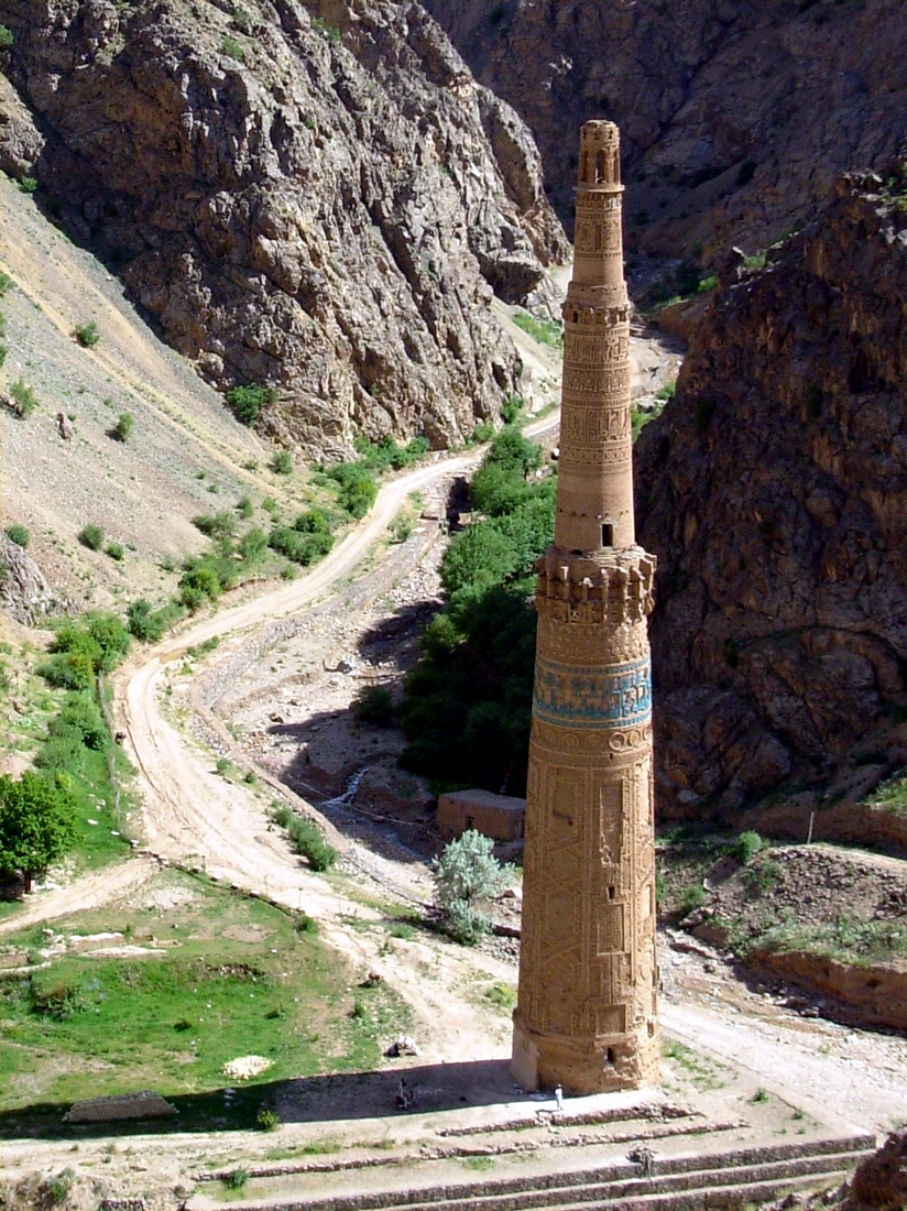
Minaret of Jam
34.3964° N · 64.5159° E · Archaeological Site
Photo: david adamec · Public domain · Wikimedia Commons
Minaret of Jam is a minaret in Afghanistan. Stands roughly sixty-five metres tall above the river confluence. The free Lokali audio guide runs 7 minutes.
✓ Published October 2026 · how we write these guides
Visitor facts
| Lokali audio guide | 7 min · free |
|---|---|
| Type | Archaeological Site |
| Location | Ghor, Afghanistan |
| Coordinates | 34.3964, 64.5159 |
| Languages | 50+, in the Lokali app |
The story
Listen first. Below you, two rivers meet. The Hari River and the smaller Jam River run fast and cold between steep, bare mountains. The water is loud here, and the valley is narrow. Then you look up. Out of this tight gorge rises a single tower of baked brick, the colour of dry earth and honey. There is no city around it. There is no road worth the name. There is only the tower, the rivers and the sky.
This is the Minaret of Jam, in the remote Shahrak district of Ghor Province, in central Afghanistan. It stands roughly sixty-five metres tall. That makes it one of the tallest brick minarets in the world, and among historic examples it is generally ranked second only to the Qutb Minar in Delhi. That ranking matters, as you will hear in a moment. For now, simply take in the scale. Few structures this tall have survived eight centuries in a place this wild.
The tower was built by the Ghurids. They were a dynasty from these same mountains. For a short period in the twelfth and early thirteenth centuries, they ruled an empire that stretched from eastern Iran into northern India. Their rise was fast, and their fall was faster. Within a few decades of their peak, the Mongol invasions swept across the region. Very little of the Ghurid world survives today. This minaret is the largest piece of it still standing.
The inscriptions on the tower name the Ghurid sultan Ghiyath al-Din Muhammad. Scholars still debate the exact year of construction. Most place it in the late twelfth century, during his reign. Some read a date in the brickwork as the 1190s. Others suggest earlier. What is not in doubt is the purpose. A minaret is the tower from which the call to prayer is made. A tower of this size, however, also announced power. It told every traveller in the valley who ruled here.
Now look closely at the surface. From a distance it seems plain. Up close, the entire shaft is covered in decoration made from the bricks themselves. Bricks are set at angles, cut and arranged to form geometric patterns, interlacing bands and lines of script. The light changes them through the day. In the morning, shadows make the patterns deep and sharp. At midday they flatten. In the evening, the brick turns warm and almost orange.
Here is the first detail many visitors miss. Among the bands of brick calligraphy is the complete text of a chapter of the Quran — Surah Maryam, the chapter named for Mary, the mother of Jesus. It is a long passage, and it winds around the tower in brick lettering. Islamic architecture often uses Quranic verses, but carrying a whole chapter on a minaret is unusual. Some scholars have linked this choice to the Ghurid conquests and to the message the rulers wanted to send.
Near the top, look for a band of colour. Most of the tower is bare brick, but up here there is a band of turquoise glazed tile. It carries an inscription in large letters naming the sultan. Against the tan brick and the grey mountains, that blue is striking. It was meant to be seen from far away. Imagine it new, catching the sun above a busy settlement, when this valley was full of people.
The tower itself is built in stages. A broad base supports a tall, tapering shaft, with further sections above. Inside, the builders made two staircases that spiral around each other. This is the second surprise. A person climbing one stair would not meet a person on the other. Visitors today should not try to climb. The structure is fragile, and its safety is a serious concern for conservators.
So why build such a tower in such an empty place? The answer may be that it was not empty. Many historians believe this valley held Firuzkuh, the summer capital of the Ghurids. Chronicles describe Firuzkuh as a great city, later destroyed by the Mongols. Its exact location was lost. Archaeological survey around Jam has found traces of walls, buildings and other remains. The evidence is strong, but not every scholar accepts it as final proof.
On the hillside nearby, there is another quiet clue. Researchers have recorded a cemetery with gravestones carrying inscriptions in Hebrew. They date to roughly the same medieval period. This shows that a Jewish community lived here, probably connected to trade. It is a reminder that the Ghurid capital, wherever its centre stood, was a mixed and connected place. Merchants, soldiers, craftsmen and scholars of different faiths passed through these mountains.
For centuries, the tower was largely unknown outside the region. Local people knew it well, of course. But the wider world only learned of it in the twentieth century. In 1957, the French archaeologist André Maricq published a study of it, and interest grew. In 2002, the Minaret and Archaeological Remains of Jam became Afghanistan's first UNESCO World Heritage Site. In the same year it was placed on the list of World Heritage in Danger.
The danger is real, and you can see some of it from here. The rivers that make this place so dramatic also threaten it. Floods and erosion attack the foundations. The tower leans, and engineers have worked to slow that lean. Looting of the surrounding archaeological sites has also been a problem. Every brick you are looking at has survived earthquakes, wars and rushing water. Its future depends on careful protection.
Before you leave, step back to a point where you can see the whole valley. Notice how small the tower looks against the mountains, and how large it looks against everything people have built here since. Listen again to the two rivers meeting at its feet. Eight centuries ago, a ruler chose this exact spot. As you walk away, look back once more. The turquoise band will still be catching the light.
Key facts
What to look for
Practical tips
Common questions
Is there a free audio guide to Minaret of Jam?
Yes — the Lokali app narrates Minaret of Jam free of charge in 50+ languages. The guide runs about 7 minutes, covers the history, what to look for on site and practical tips, and works offline once downloaded.
Where is Minaret of Jam?
Minaret of Jam is near Ghor, Afghanistan, at 34.3964, 64.5159. Tap the map link on this page for directions from where you are.
What is Minaret of Jam known for?
Stands roughly sixty-five metres tall above the river confluence. Built by the Ghurid dynasty in the late twelfth century.
What should you look for at Minaret of Jam?
Turquoise glazed tile band with the sultan's name near top. Brick calligraphy carrying the full Quranic chapter Surah Maryam. Geometric patterns formed from angled and cut bricks.
What should you know before visiting Minaret of Jam?
Check current travel advisories carefully before planning any visit. Travel only with an experienced, trusted local guide.
When is the best time to visit Minaret of Jam?
Visit in the morning when shadows sharpen the brick patterns.
On the map
Opens directions to Minaret of Jam from your location.
Hear Minaret of Jam in your language
The full story, narrated, in 50+ languages. Download it before you go and it plays offline, at your own pace, with no ticket and no tour group.