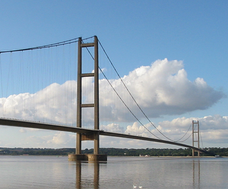
Photo: Wikimedia Commons contributor · CC BY-SA 3.0 · Wikimedia Commons
Humber Bridge is a suspension bridge near Kingston upon Hull, England. Opened to traffic in 1981 across the Humber Estuary. The free Lokali audio guide runs 8 minutes.
✓ Published October 2026 · how we write these guides
Visitor facts
| Lokali audio guide | 8 min · free |
|---|---|
| Type | Bridge |
| Location | Kingston upon Hull, United Kingdom |
| Coordinates | 53.7069, -0.4500 |
| Official website | humberbridge.co.uk |
| Languages | 50+, in the Lokali app |
The story
Listen first. Wind moves across the estuary, steady and cool, and carries the smell of mud and salt. Below you, the Humber runs wide and brown, the colour of strong tea. Above you, two long cables curve between the towers, and from the deck hang hundreds of thin steel hangers. On a breezy day you can sometimes hear the whole structure hum. This is the Humber Bridge, and it was built to join two shores that had been separated for a very long time.
The bridge crosses the Humber Estuary just west of Kingston upon Hull. On the north bank sits the town of Hessle, in the East Riding of Yorkshire. On the south bank sits Barton-upon-Humber, in North Lincolnshire. For centuries, travellers who wanted to cross here had two choices. They could take a ferry across the tidal water, or they could make a long journey inland around the estuary. The bridge replaced that slow detour with a crossing of a few minutes.
The idea of a crossing here is old. People talked about a bridge or a tunnel for generations, but the estuary is wide, the tides are strong, and the riverbed shifts. The project finally moved forward in the 1960s, and politics played a part. During a by-election in Hull in 1966, the government of the day promised that a bridge would be built. Locals still tell that story with a mix of pride and dry humour. A local songwriter even wrote a protest song about the long wait.
Construction began in the early 1970s, and it took most of that decade. The bridge opened to traffic in 1981. Later that summer, Queen Elizabeth the Second came to open it officially. When it opened, it held a world record. Its main span measures 1,410 metres between the two towers. No other single-span suspension bridge on Earth was longer. A suspension bridge, for listeners who are curious, is one where the road hangs from cables, and those cables are anchored firmly at each end.
The Humber Bridge kept that record for about seventeen years. In 1998, new bridges in Japan and Denmark finally passed it. Even today, it remains one of the longest single-span suspension bridges in the world. It is also still among the longest in Britain. For a region that people often overlook, that was a remarkable thing to hold. For nearly two decades, the longest bridge span in the world was not in a capital city. It was here, between two quiet towns on a muddy northern river.
Now look at the towers. Many famous suspension bridges use steel towers. The Humber Bridge uses concrete. Each tower stands more than 150 metres tall, and each is made of two hollow concrete legs joined by cross-beams. Here is the first detail most visitors miss. The towers stand so tall and so far apart that the curve of the Earth matters. Engineers had to set them a few centimetres further apart at the top than at the bottom. They look parallel, but they are not.
The two towers also stand in very different places. The northern tower, on the Hessle side, stands on the foreshore, close to the bank. The southern tower, on the Barton side, stands out in the water. The estuary is shallow there, but the builders still had to work against the tides and the shifting mud. Because of this, the two side spans are not the same length. The span on the southern side is much longer. Once you know this, the bridge looks a little lopsided, in a good way.
The deck itself is a steel box, shaped a little like an aircraft wing. This shape lets the wind slip over and under the road, instead of pushing hard against it. Engineers built the deck in sections on land. Then they lifted each section into place and hung it from the main cables. Those cables are not single ropes. Each one is made from thousands of thin steel wires, squeezed tightly together. Together, they carry the full weight of the road and the traffic moving across it.
Here is the second surprise. A bridge this long is never completely still. The deck moves with heat, with wind, and with the weight of lorries. On a hot day, the steel expands. On a cold day, it contracts. Joints in the road allow for this movement. If you walk across, you may feel a faint vibration under your feet as heavy vehicles pass. That is normal. The bridge was designed to flex a little, because a rigid structure would crack.
The bridge has also carried a heavy financial story. It cost far more than planned, and for decades it carried a large debt. For many people living on both banks, the tolls became a sore point. They felt they were paying for a bridge they had been promised. In the 2010s, the government agreed to reduce that debt, and tolls came down. The bridge has also been protected as a listed structure. That means Britain now treats it as part of the national heritage.
For the people of this region, the bridge did more than shorten journeys. It linked Hull more closely to Lincolnshire and to the south. Workers, students and families could now cross in minutes. Over time, it became a symbol of the area. You see its outline on local logos, on postcards and on the walls of pubs. For many people from Hull, seeing the towers on the horizon is a sign that they are almost home.
You do not need a car to enjoy it. Walkways run along both sides of the deck, and walkers and cyclists use them every day. On the northern bank, the Humber Bridge Country Park sits in an old chalk quarry. It has woodland paths, ponds and quiet corners. Down on the Hessle foreshore, you can stand almost beneath the northern tower. From there, the scale becomes clear. The road above looks thin, and the towers look very tall.
If you walk out onto the bridge, stop near the middle. The estuary opens up on both sides. To the east, the water widens toward Hull and the North Sea. To the west, it narrows toward the rivers that feed it. Ships pass underneath, and seabirds work the mudflats at low tide. Notice how the light changes on the water. On a grey day, the river and sky can look almost the same colour.
Before you leave, look up once more at the cables. Follow one curve from the top of a tower, down toward the middle of the deck, and up again to the far tower. That single line holds everything. It holds the road, the traffic and every person walking across it. When you turn back toward the shore, listen again for the wind and the hum of the steel. The bridge is still working, quietly, just as it has since 1981.
Key facts
What to look for
Practical tips
Common questions
Is there a free audio guide to Humber Bridge?
Yes — the Lokali app narrates Humber Bridge free of charge in 50+ languages. The guide runs about 8 minutes, covers the history, what to look for on site and practical tips, and works offline once downloaded.
Where is Humber Bridge?
Humber Bridge is in Kingston upon Hull, United Kingdom, at 53.7069, -0.4500. Tap the map link on this page for directions from where you are.
What is Humber Bridge known for?
Opened to traffic in 1981 across the Humber Estuary. Main span measures 1,410 metres between the two towers.
What should you look for at Humber Bridge?
Hollow concrete tower legs joined by horizontal cross-beams. Southern tower standing out in the estuary water. Thin vertical steel hangers dropping from the main cables.
What should you know before visiting Humber Bridge?
Walk the footpath on the deck for estuary views. Visit Hessle foreshore to stand near the northern tower.
On the map
Opens directions to Humber Bridge from your location.
More to see near Humber Bridge

Hear Humber Bridge in your language
The full story, narrated, in 50+ languages. Download it before you go and it plays offline, at your own pace, with no ticket and no tour group.