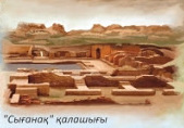
Sighnaq
44.1567° N · 66.9639° E · Archaeological Site
Photo: Post of Kazakhstan · Public domain · Wikimedia Commons
Sighnaq is a capital of the Blue/White Horde, the Uzbek Khanate and the Kazakh Khanate. Sighnaq stands in the Syr Darya valley, southern Kazakhstan. The free Lokali audio guide runs 7 minutes.
✓ Published October 2026 · how we write these guides
Visitor facts
| Lokali audio guide | 7 min · free |
|---|---|
| Type | Archaeological Site |
| Location | Kyzylorda, Kazakhstan |
| Coordinates | 44.1567, 66.9639 |
| Languages | 50+, in the Lokali app |
The story
Listen first. The wind moves across open steppe and catches the dry grass. Underfoot, the ground crunches. Look down, and you may see why. The surface is scattered with small pieces of fired clay, some red, some grey, a few with traces of old glaze. These are fragments of pots, bowls and jugs. People used them here centuries ago. In front of you rises a long, low mound of earth. It does not look like a city. It once was.
This is Sighnaq, also written Syganak, in the Kyzylorda Region of southern Kazakhstan. It lies in the valley of the Syr Darya, one of the two great rivers of Central Asia. The river flows from the mountains to the east and once ran into the Aral Sea. Please do not confuse this place with Sighnaghi, the hilltop town in Georgia. The names sound alike, but the two places are thousands of kilometres apart. They have separate histories.
The name is often explained as coming from an old Turkic word for a shelter or a refuge. That fits the setting. Here, the river valley gave water, fields and pasture. Around it, the steppe stretched in every direction. Caravans moved along the river between the oasis towns of the south and the grasslands of the north. A walled town on this route offered protection, a market, and a place to rest. Sighnaq grew because it stood where these worlds met.
Medieval writers already knew the town by the eleventh century. In those years, the lower Syr Darya was home to Turkic peoples. Some lived as herders on the open steppe. Others settled in towns along the water. Towns like Sighnaq were places where these two ways of life traded with each other. Herders brought livestock, wool and leather. Townspeople offered grain, pottery, metalwork and cloth. That exchange between steppe and town gives this whole region its character.
Then came the Mongols. Around 1219 and 1220, armies sent by Genghis Khan moved down the Syr Darya. According to medieval Persian chroniclers, the Mongols sent an envoy to Sighnaq and asked the town to surrender. The people of the town killed the envoy instead. The Mongol forces then besieged the town. The chroniclers say the defenders resisted for several days. After that, the town was stormed and many inhabitants died. It is a hard story to hear while you stand on the same ground.
Sighnaq did not disappear. Over the following decades, the town recovered. Here is a surprise for many visitors. In the fourteenth century, this mound was a capital. Sighnaq became the main seat of the White Horde. This was the eastern branch of the realm founded by Jochi, the eldest son of Genghis Khan. Rulers such as Urus Khan held power from here. For a time, decisions about a large part of the steppe were made at this place.
The fifteenth century brought new rivalries. Different branches of the steppe dynasties fought for the towns of the Syr Darya. Control of Sighnaq meant control of trade and taxes. Historians link this struggle to the beginnings of the Kazakh Khanate. Its founders, the khans Kerei and Janibek, came from the line of Urus Khan. In the following generations, Kazakh rulers fought for the river towns, and Sighnaq was among them. So this quiet mound is part of the early story of the Kazakh state.
Now look again at the shards by your feet. Archaeological work at Sighnaq has found ceramics, coins and traces of daily life. The glazed pieces show that the town had skilled potters. It also had links to the wider craft traditions of Central Asia. Coins show trade and the authority of rulers. Each small fragment here was once part of something whole. Please leave them where they lie. Together, they are part of the site's record.
How did a capital become a mound of earth? Historians usually point to several causes. Rivers in this region change their beds over time, and a town that loses its water loses its life. Trade routes also shifted. Wars between rival powers took a toll. Over the following centuries, people left. Mud brick does not last when nobody repairs it. Rain and wind wore the walls down, slowly, until only these soft shapes remained.
Take a moment to read the shapes in the land. The raised ground shows where buildings and walls once stood. In many places, you can follow a line that marks the old outer defences. Higher parts often mark a citadel, the fortified core where rulers lived. The material here is mostly earth and sun-dried brick. There is little stone. This was the common way to build in the river valleys of Central Asia, where clay was plentiful.
Now turn and look at the wider landscape. The steppe is flat and open, and the sky feels very large here. In spring, the ground can turn green for a short time. In summer, it fades to straw and dust. Low, tough shrubs grow in the dry soil. In the distance, you may notice the railway line that crosses this region. Trains still follow the river corridor, like the caravans once did.
A few practical notes. This is an open site with very little shade. The sun can be strong, and the wind can carry dust. Bring water, a hat and good shoes. The ground is uneven, and the slopes of the mound can be loose. Walk slowly. Local people treat sites like this with respect, and some come to nearby holy places to pray. Speak quietly, and follow paths where you see them.
Before you leave, stand still for one more minute. Listen to the wind again. It is the same wind that blew over merchants, soldiers and khans on this ground. Look at the long outline of the mound against the sky. Then look at the clay fragments, which are small, broken and ordinary. A capital once stood here. As you walk back, notice how quickly the mound blends into the steppe... and remember what the land is still holding.
Key facts
What to look for
Practical tips
Common questions
Is there a free audio guide to Sighnaq?
Yes — the Lokali app narrates Sighnaq free of charge in 50+ languages. The guide runs about 7 minutes, covers the history, what to look for on site and practical tips, and works offline once downloaded.
Where is Sighnaq?
Sighnaq is near Kyzylorda, Kazakhstan, at 44.1567, 66.9639. Tap the map link on this page for directions from where you are.
What is Sighnaq known for?
Sighnaq stands in the Syr Darya valley, southern Kazakhstan. Mongol armies besieged and stormed the town around 1219-1220.
What should you look for at Sighnaq?
Scattered red and grey pottery shards across the ground. Fragments with traces of old coloured glaze. Raised ridges tracing the line of the old walls.
What should you know before visiting Sighnaq?
Bring plenty of water; the site has almost no shade. Wear sturdy shoes for loose, uneven slopes on the mound.
When is the best time to visit Sighnaq?
Visit early morning or late afternoon to avoid midday heat.
On the map
Opens directions to Sighnaq from your location.
Hear Sighnaq in your language
The full story, narrated, in 50+ languages. Download it before you go and it plays offline, at your own pace, with no ticket and no tour group.