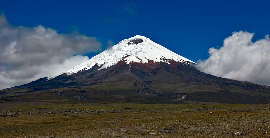
Cotopaxi National Park
0.6842° S · 78.4372° W · National Park
Photo: Gerard Prins · CC BY-SA 3.0 · Wikimedia Commons
Cotopaxi National Park is a protected area in Ecuador. Cotopaxi's summit rises close to 5,900 metres. The free Lokali audio guide runs 7 minutes.
✓ Published October 2026 · how we write these guides
Visitor facts
| Lokali audio guide | 7 min · free |
|---|---|
| Type | National Park |
| Location | Latacunga, Ecuador |
| Coordinates | -0.6842, -78.4372 |
| Languages | 50+, in the Lokali app |
The story
The air is thin here, and it is cold even under a bright sun. Take a slow breath and you may feel your heart work a little harder. Under your boots, the ground crunches. It is grey volcanic sand mixed with pale, light pieces of pumice. The wind moves steadily across open grassland. Then you look up, and there it is: a nearly perfect cone, capped in white, rising over everything.
That cone is Cotopaxi, one of the highest active volcanoes on Earth. Its summit stands close to 5,900 metres above sea level. The national park around it protects the volcano, its glaciers, and a wide band of high Andean grassland. The park was created in the 1970s, which makes it one of the oldest protected areas in mainland Ecuador. For most visitors, the journey starts in Latacunga, a city that has lived in this mountain's shadow for centuries.
Look at the shape of the peak for a moment. Many volcanoes are broken, jagged, or slumped. Cotopaxi is different. Its sides rise in long, even slopes toward a summit crater. That clean geometry is a sign of a young, active volcano. Eruption after eruption has added fresh layers of lava, ash, and rock. Nothing has had time to wear the mountain down.
The white cap is a glacier, and it matters more than it seems. When Cotopaxi erupts, hot material can melt that ice very quickly. The meltwater mixes with ash and loose rock and becomes a lahar — a fast flow of mud and debris that moves down river valleys like wet concrete. For the people of the valley, the real danger from this mountain has always been the mud, more than the lava.
History shows how serious that danger is. Latacunga was hit hard by eruptions in colonial times, and the city was rebuilt more than once. The great eruption of 1877 sent lahars rushing down the valleys. Historical accounts describe mudflows that travelled enormous distances, some of them reaching the Pacific coast. Today, the region has warning systems and marked evacuation routes. Keep an eye out for the signs on the roads around Latacunga.
The mountain stayed fairly quiet through much of the twentieth century. That changed in 2015. Cotopaxi woke up with steam, ash, and small explosions, and the authorities closed parts of the park for a time. Ash fell on farms and towns nearby. The volcano has had more restless periods since then. So the peak in front of you is not a museum piece. It is a living system, and scientists monitor it every day.
Now turn your attention to the land at your feet. This is the páramo, a high, cold grassland found in the northern Andes. It is a tough place to live. Nights can freeze, and days can be strong with sunlight. The plants stay low and grow in thick clumps. Many have fine hairs or waxy leaves that protect them from frost and ultraviolet light. Get down on one knee and you will see small flowers hidden among the tussocks.
Here is something many visitors do not realise. The páramo works like a giant sponge. Its soils and mosses soak up rain, mist, and glacial melt, and then they release that water slowly. Across the Ecuadorian Andes, grasslands like this one help feed rivers and supply water to towns and cities below. So this quiet, windswept ground matters to millions of people who will never stand here.
Watch the open plains as you move through the park. Herds of wild horses graze here, and they often stand still against the wind. Andean lapwings call out loudly if you get too close to them. With luck, you may spot a white-tailed deer, or a páramo fox trotting through the grass. Birders keep watching the sky for the Andean condor, a huge vulture with very wide wings. Sightings are rare, but they do happen.
Many visitors stop at Limpiopungo, a shallow lagoon at the foot of a darker, older peak called Rumiñahui. On a calm day, the water holds a reflection of Cotopaxi. On a windy day, it turns grey and choppy. A simple trail goes around the shore, and water birds feed in the reeds. At this altitude, even a flat walk feels like work. Walk slowly, and stop often.
Higher up, a dirt track climbs toward a mountain refuge named after José Rivas, at roughly 4,800 metres. The last stretch is on foot, through loose sand, and it is hard. Some people turn back, and that is a wise choice. Climbers use the refuge as a base for summit attempts. Those climbs start in the middle of the night, need a licensed guide, and depend on the volcano's current activity.
Cotopaxi has drawn explorers for a long time. The German naturalist Alexander von Humboldt studied this region in the early nineteenth century, but he did not reach the summit. The first recorded ascent came in 1872, by the geologist Wilhelm Reiss and his Ecuadorian companion Ángel Escobar. Locals also share a popular tale that the name means "neck of the moon" in an Indigenous language. Linguists are not sure about that, but it is a lovely image.
Weather here changes fast. A clear morning can turn into fog by noon, and the cone can disappear completely behind clouds in minutes. Then, just as suddenly, the clouds can open again. Local guides often say that patience is the best tool on this mountain. If the summit is hidden right now, give it time. The view often comes back.
Before you leave, stand still for one more minute. Listen to the wind in the grass, and maybe a horse moving somewhere far away. Feel the cold on your face and the sun on your hands at the same moment. Look once more at that white cone, quiet for now. Then, as you head back down toward Latacunga, watch the river valleys. You will be following the same paths the mud has taken for centuries.
Key facts
What to look for
Practical tips
Common questions
Is there a free audio guide to Cotopaxi National Park?
Yes — the Lokali app narrates Cotopaxi National Park free of charge in 50+ languages. The guide runs about 7 minutes, covers the history, what to look for on site and practical tips, and works offline once downloaded.
Where is Cotopaxi National Park?
Cotopaxi National Park is near Latacunga, Ecuador, at -0.6842, -78.4372. Tap the map link on this page for directions from where you are.
What is Cotopaxi National Park known for?
Cotopaxi's summit rises close to 5,900 metres. Park was created in the 1970s.
What should you look for at Cotopaxi National Park?
Pale, lightweight pumice in the grey volcanic sand. Cotopaxi's reflection in Limpiopungo lagoon on calm days. Wild horses grazing on the open páramo plains.
What should you know before visiting Cotopaxi National Park?
Spend a night or two in Latacunga to acclimatise first. Walk slowly and drink plenty of water at altitude.
When is the best time to visit Cotopaxi National Park?
Arrive early, before clouds usually cover the summit.
On the map
Opens directions to Cotopaxi National Park from your location.
Hear Cotopaxi National Park in your language
The full story, narrated, in 50+ languages. Download it before you go and it plays offline, at your own pace, with no ticket and no tour group.