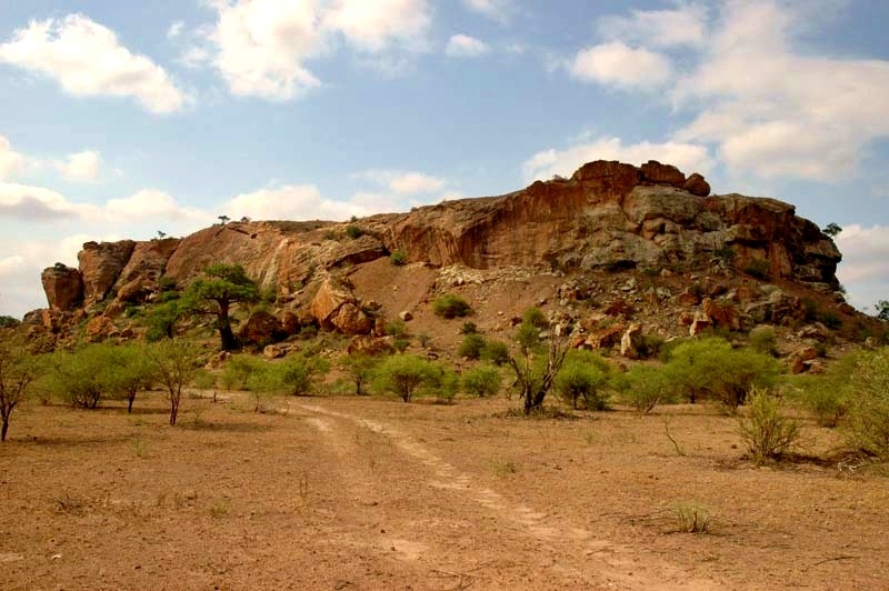
Mapungubwe National Park
22.2281° S · 29.2126° E · National Park
Photo: JJ van Zyl · CC BY-SA 3.0 · Wikimedia Commons
Mapungubwe National Park is a national park in Limpopo, South Africa. Listed as a UNESCO World Heritage Site in 2003. The free Lokali audio guide runs 6 minutes.
✓ Published October 2026 · how we write these guides
Visitor facts
| Lokali audio guide | 6 min · free |
|---|---|
| Type | National Park |
| Location | Limpopo, South Africa |
| Coordinates | -22.2281, 29.2126 |
| Official website | sanparks.org |
| Languages | 50+, in the Lokali app |
The story
Feel the heat rising from the sandstone under your shoes. It is red-brown and rough, and in the middle of the day it holds the sun like a stove. Around you, baobab trees stand with their thick grey trunks and bare, root-like branches. The air smells of dry grass and dust. Somewhere below, a hornbill calls. This quiet stretch of the Limpopo valley does not look like the heart of a kingdom. But eight hundred years ago, it was exactly that.
Welcome to Mapungubwe National Park, in the far north of South Africa. You are close to the point where the Limpopo River meets the Shashe River. At that confluence, three countries touch: South Africa, Botswana and Zimbabwe. Animals cross these borders freely, and so did people, long before any border existed. The park protects both wildlife and one of the most important archaeological landscapes on the African continent. In 2003, UNESCO listed it as a World Heritage Site.
So what happened here? Around the early thirteenth century, a society on this river grew into something new. Archaeologists consider Mapungubwe the centre of one of the first kingdoms in southern Africa. Its people farmed sorghum and millet on the floodplains. They kept cattle, which meant wealth and status. And they traded. The kingdom lasted only a few generations, perhaps until around 1300, but its influence travelled far beyond this valley.
The trade is the first surprise. Excavations here have recovered thousands of glass beads that came from far across the Indian Ocean. Fragments of Chinese celadon, a pale green glazed pottery, have also been found. In return, gold and ivory moved east toward the Swahili coast and on to distant markets. So this dry inland valley was linked, through a long chain of traders, to Arabia, India and China. It was part of a global economy centuries before Europeans arrived.
Before Mapungubwe Hill became the royal seat, people lived at a nearby settlement that archaeologists call K2. You may also hear the name Bambandyanalo. Over time, the population and its wealth grew. Then the leadership moved up onto the flat-topped hill. This move matters. Researchers see it as a sign of a new kind of society, one where rulers lived apart and above ordinary people.
That physical separation is the heart of the story. The elite lived on the summit. Commoners lived on the land below. Many scholars describe Mapungubwe as one of the earliest class-based societies in southern Africa. The king was hidden from view, high on the rock. Later states in the region, including Great Zimbabwe to the north, appear to have followed a similar pattern. Many archaeologists see Mapungubwe as a forerunner of Great Zimbabwe.
Now for the object that made this place famous. In the 1930s, people climbed the hill and found graves near the summit. Among the burial goods was a small rhinoceros. It was made from thin sheets of gold, hammered and tacked onto a wooden core that has since decayed. It is small enough to hold in your hand. Today it is often called the Golden Rhino, and it has become a national symbol.
Here is a second surprise. The Golden Rhino is not kept in the park. The original is held, with other gold objects from the graves, by the University of Pretoria, which led the early excavations. The rhino shows how highly this society valued both gold and the animals around it. Its image also appears in South Africa's highest national honour, the Order of Mapungubwe, named after this kingdom.
Why did the kingdom fade? Nobody can say with full certainty. Many researchers point to a change in climate. The region seems to have become cooler and drier at the end of the thirteenth century, which would have made floodplain farming much harder. As people moved away, power shifted north toward Great Zimbabwe. Locals have long treated the hill with respect, and some say it was a sacred place to be avoided. Treat that as tradition rather than recorded history.
The Interpretation Centre near the main gate is worth your time. Its design is unusual. Rounded vaults, built from locally made earth tiles, rise from the ground like the rock forms around them. The architect, Peter Rich, wanted the building to belong to this landscape, and it won international praise for that approach. Inside, displays explain the kingdom and show replicas and artefacts from the excavations. Seeing it first will make the hill much easier to read.
The living park is just as rewarding. Elephants move through the mopane woodland and along the rivers. Look for klipspringers, small antelope that balance on the rocks with neat, pointed hooves. Giraffe, kudu and many birds are common. Lions and leopards are present too, but seeing them is a matter of luck. Near the confluence, a treetop walkway runs through the riverine forest. It lets you look down into the canopy and along the water.
From the viewpoints above the confluence, you can see the meeting of the two rivers. For much of the year, the Shashe and Limpopo may be wide channels of sand rather than water. In the wet season they can flood. Look across, and the land on the far side is Botswana on one bank and Zimbabwe on the other. Very few places let you look into two neighbouring countries at once.
Take a moment before you move on. Look at the sandstone hill, flat and low against the sky. It does not look like a palace. There are no towers and no great walls. Yet people once climbed it carrying ivory, gold and beads from across an ocean. As you walk back, listen to the insects in the grass and watch the baobabs. Some of those trees are very old, and they still stand in this valley today.
Key facts
What to look for
Practical tips
Common questions
Is there a free audio guide to Mapungubwe National Park?
Yes — the Lokali app narrates Mapungubwe National Park free of charge in 50+ languages. The guide runs about 6 minutes, covers the history, what to look for on site and practical tips, and works offline once downloaded.
Where is Mapungubwe National Park?
Mapungubwe National Park is in Limpopo, South Africa, at -22.2281, 29.2126. Tap the map link on this page for directions from where you are.
What is Mapungubwe National Park known for?
Listed as a UNESCO World Heritage Site in 2003. Kingdom flourished in the thirteenth century.
What should you look for at Mapungubwe National Park?
Earth-tile vaults of the Interpretation Centre roof. Flat summit of Mapungubwe Hill above the plain. Grey baobab trunks scattered across the sandstone.
What should you know before visiting Mapungubwe National Park?
Visit the Interpretation Centre before climbing the hill. Book a guided hill tour in advance at reception.
When is the best time to visit Mapungubwe National Park?
Drive to the confluence viewpoint in late afternoon.
On the map
Opens directions to Mapungubwe National Park from your location.
Hear Mapungubwe National Park in your language
The full story, narrated, in 50+ languages. Download it before you go and it plays offline, at your own pace, with no ticket and no tour group.