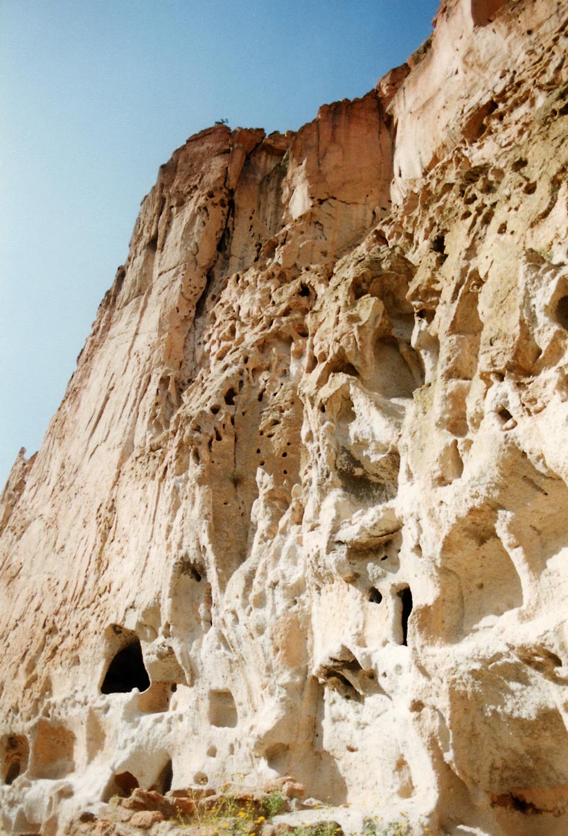
Bandelier National Monument
35.7789° N · 106.3210° W · Archaeological Site
Photo: Andrew Dunn (talk · contribs) · CC BY-SA 2.0 · Wikimedia Commons
Bandelier National Monument is a U.S. national park in New Mexico. Cliffs are volcanic tuff from ancient Jemez Mountains eruptions. The free Lokali audio guide runs 7 minutes.
✓ Published October 2026 · how we write these guides
Visitor facts
| Lokali audio guide | 7 min · free |
|---|---|
| Type | Archaeological Site |
| Location | Los Alamos County, United States |
| Coordinates | 35.7789, -106.3210 |
| Official website | nps.gov |
| Languages | 50+, in the Lokali app |
The story
Listen first. Somewhere below the cliffs, Frijoles Creek is running over stones. A raven calls from the rim. The air smells of warm pine resin and dry earth. Under your feet, the trail is pale and gritty, almost like crushed chalk. Look up at the canyon wall beside you. It is soft, honey-coloured rock, full of small holes and hollows. Some of those holes were made by wind and water. Others were made by human hands, many centuries ago.
You are standing in Frijoles Canyon, on the Pajarito Plateau of northern New Mexico. Frijoles means beans in Spanish, a name that hints at the farming life of this place. The canyon cuts deep into a high tableland of mesas and forests. To the west rise the Jemez Mountains. To the east, the land falls away toward the Rio Grande. This is Bandelier National Monument. For several hundred years, this quiet canyon was a home, a farm, and a community.
To understand the canyon, start with the rock. More than a million years ago, enormous volcanic eruptions in the Jemez Mountains threw out vast clouds of ash. That ash settled across the plateau, layer upon layer, and slowly hardened. Geologists call this rock tuff — compacted volcanic ash. It is light and soft. You can scratch it with a harder stone. Over time, creeks carved canyons through it, and the exposed walls weathered into holes, ledges, and alcoves.
That softness is the key to everything you see here. The Ancestral Pueblo people who settled this canyon used simple stone tools to enlarge natural hollows in the cliff. The result was small rooms cut directly into the rock. Today these rooms are called cavates. Many visitors walk past and assume they are just caves. Look more closely. You may see smoothed walls, flat floors, and ceilings darkened by the smoke of old cooking fires. These were bedrooms, storage rooms, and work spaces.
People lived in Frijoles Canyon from roughly the twelfth century to the sixteenth century. They were farmers. On the mesa tops and along the canyon floor, they grew corn, beans, and squash. They also kept turkeys, which gave them feathers for blankets as well as meat. They hunted deer and gathered wild plants. Water from the creek, careful planning, and a deep knowledge of the seasons kept this community alive in a dry landscape.
On the canyon floor, you will find a large circular ruin called Tyuonyi. From above, its outline looks like a ring of low stone walls. Here, it is good to be honest about numbers. Estimates suggest several hundred rooms, built mostly from blocks of tuff. In places, the village probably rose two or three stories tall. A single passage led into the central plaza. Imagine the plaza full of people grinding corn, children running, smoke rising from many roofs.
Near Tyuonyi, look for round pits sunk into the ground. These are kivas — underground ceremonial rooms. In Pueblo tradition, a kiva is a space for ritual, teaching, and community gatherings. People entered from above, by ladder, through an opening in the roof. Kivas are still used in Pueblo communities today. That is worth remembering as you walk. This place is not a dead ruin. For living Pueblo people, it is an ancestral home with real spiritual meaning.
Follow the trail along the base of the cliff, and you reach a section known as Long House. Here, houses were once built against the cliff face, several stories high, stretching along the wall. The masonry rooms have mostly fallen. But the cliff itself still carries the evidence. Look for neat rows of small round holes. These sockets once held the wooden roof beams, called vigas. Each row marks a floor that no longer exists.
Now look for something many visitors miss. On parts of the cliff at Long House, you can see carvings pecked into the rock, called petroglyphs. Some show animals, human figures, and spirals. In a few sheltered spots, traces of old plaster survive, sometimes with painted designs. Please only look, and never touch. The oils from human hands slowly damage these surfaces. They have lasted for centuries, and they are fragile.
If you have energy and a steady head for heights, the trail continues upstream to Alcove House. This is a large natural shelter high in the canyon wall. To reach it, you climb a series of wooden ladders and stone steps, roughly forty metres above the canyon floor. Inside the alcove is a reconstructed kiva. From up there, the view down the canyon shows how the whole community fitted together — fields, creek, village, and cliff.
Why did people leave? Historians and archaeologists point to several likely causes. A long drought hit the region in the late thirteenth and sixteenth centuries. Soils may have worn out after generations of farming. By the mid sixteenth century, the people of Frijoles Canyon had moved toward the Rio Grande. Their descendants live today in nearby Pueblos, including Cochiti and San Ildefonso. Their oral traditions still connect them to this canyon.
The monument takes its name from Adolph Bandelier, a Swiss-American scholar. In 1880, men from Cochiti Pueblo guided him into this canyon. He studied the ruins and later wrote a novel set here, imagining the lives of its people. In 1916, the area was declared a national monument. In the 1930s, young men of the Civilian Conservation Corps, a Depression-era work programme, built the stone and timber buildings near the visitor centre. Those buildings are now historic in their own right.
The canyon has faced hard times recently. In 2011, a large wildfire burned across much of the surrounding plateau. Floods followed, because burned slopes cannot hold back rain. You may still notice dark tree trunks on the ridges above. You may also notice new growth — grasses, shrubs, and young trees returning. Watch for mule deer at the edge of the meadows, and for Abert's squirrels, with their tall tufted ears, in the ponderosa pines.
Before you walk away, pause once more by the cliff. Put your hand near the wall, but not on it, and feel the warmth the rock holds from the sun. Listen again for the creek. The same water ran here when this canyon was full of homes and voices. As you head back along the trail, glance up at the small dark openings in the rock. Each one was somebody's room, somebody's shelter from the winter wind.
Key facts
What to look for
Practical tips
Common questions
Is there a free audio guide to Bandelier National Monument?
Yes — the Lokali app narrates Bandelier National Monument free of charge in 50+ languages. The guide runs about 7 minutes, covers the history, what to look for on site and practical tips, and works offline once downloaded.
Where is Bandelier National Monument?
Bandelier National Monument is near Los Alamos County, United States, at 35.7789, -106.3210. Tap the map link on this page for directions from where you are.
What is Bandelier National Monument known for?
Cliffs are volcanic tuff from ancient Jemez Mountains eruptions. Ancestral Pueblo people lived here roughly twelfth to sixteenth century.
What should you look for at Bandelier National Monument?
Rows of round beam sockets along the Long House cliff. Smoke-blackened ceilings inside the small carved cavate rooms. Petroglyph spirals and animal figures pecked into rock.
What should you know before visiting Bandelier National Monument?
Wear shoes with good grip for gritty tuff paths. Carry water; the canyon sits at high, dry elevation.
When is the best time to visit Bandelier National Monument?
Visit early morning for cooler air and quieter trails.
On the map
Opens directions to Bandelier National Monument from your location.
Hear Bandelier National Monument in your language
The full story, narrated, in 50+ languages. Download it before you go and it plays offline, at your own pace, with no ticket and no tour group.