Zero Mile Stone is a historic marker at the geographical center of India, established during the British Raj as the reference point for measuring distances across the country. It is in Nagpur, India. Most visitors spend 15–20 min here. The free Lokali audio guide runs 5 minutes.
✓ Verified August 2026 · how we write these guides
Visitor facts
| Time needed | 15–20 min |
|---|---|
| Lokali audio guide | 5 min · free |
| Type | Landmark |
| Best for | Photography |
| Location | Nagpur, India |
| Coordinates | 21.1458, 79.0882 |
| Languages | 45, in the Lokali app |
The story
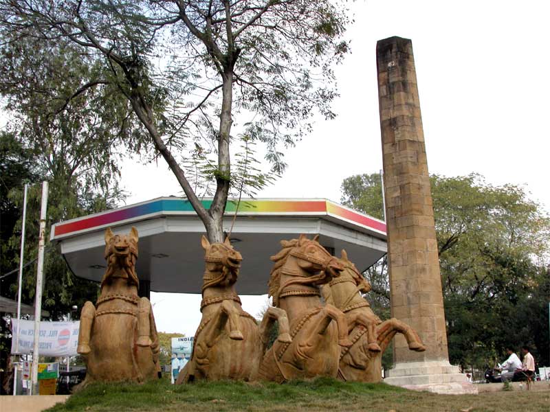
You stand on a quiet traffic island, and in front of you is a slim pillar of pale sandstone. Around its base, four stone horses face outward, frozen mid-step. Cars pass close by, and most drivers do not slow down. The stone is warm and a little rough where the weather has worn it. Yet this small pillar once marked what the British called the very center of India. Traffic hums in a steady ring around the island. A few pigeons lift and settle on the horses' backs. It would be easy to walk straight past this without a second glance.
The monument is called the Zero Mile Stone. The British built it in 1907, during a vast project known as the Great Trigonometrical Survey of India. For nearly a century, surveyors had been measuring the whole subcontinent, step by step, in order to map it with care. The survey was one of the largest scientific efforts of its age, and it took more than sixty years of slow, patient labor. This pillar was one of the points they fixed.
Run your eyes up the column. It is made of sandstone, weathered now by more than a hundred monsoon seasons. Beside it sits a smaller stone, lower to the ground. That smaller stone marks the official survey point, the exact spot from which the distances were counted outward.
Why here, in Nagpur? The British chose this city because it sat near the middle of their Indian territory. From a central point, it was easier to measure distances to far cities and to plan the roads and railway lines that would one day stretch across the land.
The four horses are worth a closer look. They were added later, set around the base, each one facing a different direction. They seem to stand guard, pointing outward toward the distant corners of the country that the surveyors once charted on their maps. Their stone bodies have faded and chipped over the years, yet they still hold their poses against the sun and rain.
On the pillar, old markings once listed the distances from this point to major towns. To read them was to feel the size of a whole nation laid out in plain numbers. Every one of those miles began, in a sense, right where you are standing now.
There is a pleasing idea hidden here. Nagpur sits roughly in the middle of India's main cities. Draw lines outward to Delhi, Mumbai, Kolkata, Chennai, and several others, and this region falls near their shared center. The British noticed this, and they placed their marker to match.
There is even a precise number tied to this place. The top of the pillar stands about three hundred eleven meters above the level of the sea, a height fixed by the survey's careful instruments. Such details meant little to passers-by, but to a mapmaker they were everything.
After India became independent in 1947, the borders changed, and the country was later reorganized. The official geographical center shifted elsewhere, to a village further north. Nagpur lost the title on paper. But the people of the city kept the old stone in their memory. Many here still call Nagpur the heart of the country, and they point to this pillar as the proof.
Stand quietly for a moment and think about what this pillar really represents. It is not a temple or a palace. It is a tool. It was the starting point of maps, a single fixed dot from which an empire measured the ground that it claimed.
The surveyors who placed it worked with chains, telescopes, and careful mathematics. They climbed hills and crossed plains to fix their measurements. The numbers they gathered shaped the maps that the country would use for generations. This pillar is a small monument to that slow and patient work. Standing here, you are looking at one quiet anchor of that enormous map, fixed in place and never once moved.
Today the spot is calm. Government buildings stand nearby. Pigeons settle on the horses' backs. A few visitors stop to read the plaque and take a photograph, then move on. The traffic keeps up its steady flow around the island, hour after hour.
Before you go, look once more at the warm sandstone. Think of the long lines drawn outward from this point, across rivers and dry plains and crowded streets, all the way to the distant sea. From this quiet corner, someone once measured a country. And then they wrote it all down.
Key facts
What to look for
Practical tips
Common questions
How long do you need at Zero Mile Stone?
Plan 15–20 min. That is the time most visitors spend at Zero Mile Stone. The free Lokali audio guide adds about 5 minutes of narration you can listen to as you walk, so it fits inside your visit rather than adding to it.
Is there a free audio guide to Zero Mile Stone?
Yes — the Lokali app narrates Zero Mile Stone free of charge in 50+ languages. It covers the history, what to look for on site and practical tips, and it works offline once downloaded.
Where is Zero Mile Stone?
Zero Mile Stone is in Nagpur, India, at 21.1458, 79.0882. Tap the map link on this page for directions from where you are.
What should you know before visiting Zero Mile Stone?
Cross the busy road carefully to reach the island.
What is Zero Mile Stone known for?
The British built the Zero Mile Stone in 1907.
What is the best time to visit Zero Mile Stone?
The stone sits in a small plaza surrounded by busy streets—a quiet pocket in urban Nagpur.
On the map
Opens directions to Zero Mile Stone from your location.
More to see in Nagpur


Hear Zero Mile Stone in your language
The full story, narrated, in 50+ languages. Download it before you go and it plays offline, at your own pace, with no ticket and no tour group.