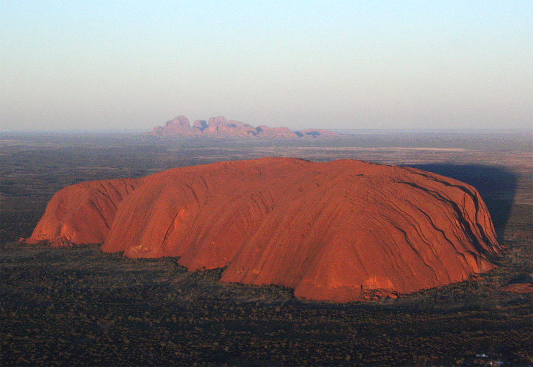
Uluṟu-Kata Tjuṯa National Park
25.3221° S · 130.9857° E · National Park
Photo: Leonard G. · Public domain · Wikimedia Commons
Uluṟu-Kata Tjuṯa National Park is a national park in the Northern Territory, Australia and location of a sandstone monolith. Uluṟu rises roughly 350 metres above the surrounding plain. The free Lokali audio guide runs 7 minutes.
✓ Published October 2026 · how we write these guides
Visitor facts
| Lokali audio guide | 7 min · free |
|---|---|
| Type | National Park |
| Location | Northern Territory, Australia |
| Coordinates | -25.3221, 130.9857 |
| Official website | ea.gov.au |
| Languages | 50+, in the Lokali app |
The story
Listen first. Out here the silence has a texture. A light wind moves through the spinifex grass, a bird calls somewhere far off, and red sand shifts under your shoes. The ground is fine and soft, the colour of rust. Ahead of you, a single shape of stone rises from the flat desert. It looks almost too large and too smooth to be real. This is Uluṟu, and you are standing in one of the oldest living cultural landscapes on Earth.
The people of this country are the Aṉangu. Their two main languages here are Pitjantjatjara and Yankunytjatjara. For Aṉangu, this park is not wilderness, and the rock is not simply a geological wonder. It is a place shaped by ancestral beings, and it is full of law, stories and responsibility. That body of knowledge is called Tjukurpa. It explains how the land was formed, and it also guides how people should live, share and care for country today.
Now look at the rock itself. Uluṟu is made of arkose, a coarse sandstone rich in a mineral called feldspar. Here is the first surprise. The famous red colour is only skin deep. Iron in the stone reacts with oxygen, and it rusts on the surface. Where rock has broken away, you can sometimes see the grey stone underneath. The whole monument is wearing a thin coat of rust, and that coat glows when the sun is low.
Here is a second surprise. The layers of sandstone inside Uluṟu do not lie flat. Over hundreds of millions of years, earth movements tilted them until they stand almost on end. Walk close and you will see long parallel grooves running up the face. Those grooves are the edges of ancient layers of sediment, turned on their side. Geologists also believe a large part of the rock continues deep underground, below the plain you are standing on.
The numbers are worth a moment. Uluṟu rises roughly three hundred and fifty metres above the surrounding plain. A walk all the way around its base covers about ten kilometres. Many visitors expect a simple dome. Up close, it is anything but simple. There are caves, overhangs, waterholes, deep folds and pitted hollows. The surface changes every few steps. Light catches a ridge, then falls into shadow, and the rock seems to change its shape as you move.
Around the base, Aṉangu stories are tied to specific features. One publicly shared story tells of Kuniya, a woman python, and Liru, a venomous snake. Their battle is recorded in marks on the rock near Mutitjulu Waterhole. Another tells of the Mala, the rufous hare-wallaby people. These are not legends in the casual sense. For Aṉangu they are law. Some parts of these stories are shared with visitors, and many other parts are kept only for those with the right to know.
That is why you will see signs asking you not to photograph certain sections of the rock. These are sensitive sites, connected to men's or women's business. Seeing them in photographs elsewhere can cause real distress to the people responsible for them. It may feel unusual, putting the camera down in front of something so beautiful. But it is a simple way to show respect. The rock is still there to look at, and to remember.
The modern history of the park is a story of names and of ownership. In 1873, the explorer William Gosse named the rock Ayers Rock, after Henry Ayers, a South Australian politician. For more than a century that was the name most outsiders used. Then, in October 1985, the title to the land was formally handed back to its traditional owners. Aṉangu then leased the park to the national parks agency, and the two now manage it together.
For many years, visitors climbed Uluṟu along a steep path on its western side. Aṉangu had long asked people not to climb, for cultural reasons and for safety. The joint management board decided to close the climb, and it ended in October 2019. You may still see faint traces of the old route on the rock. Today the invitation is different. Walk around the base, listen to the stories, and see the rock from the ground, the way Aṉangu always have.
Now turn your eyes west. On the horizon, about forty kilometres away, sits a cluster of great rounded domes. That is Kata Tjuṯa, a name that means many heads. There are around thirty-six domes, and the tallest rises even higher than Uluṟu. The stone is different too. Kata Tjuṯa is a conglomerate, a rock made of pebbles, cobbles and boulders cemented together in sand and mud. Up close, it looks like a vast wall of set stones.
Walking in Kata Tjuṯa feels very different from walking at Uluṟu. Trails lead into narrow gorges and between the domes, where the wind can funnel through and the air turns cool in the shade. Walpa Gorge is a short walk between two steep walls. The longer Valley of the Winds track loops through open country and tight passages. Kata Tjuṯa is also a sacred place under Tjukurpa, and much of its story is not shared with visitors at all.
The whole park is recognised by UNESCO as a World Heritage site. It was first listed for its natural values. Later it was listed again for its cultural landscape. It was one of the first places in the world to be recognised in that way. That second listing matters. It acknowledges that the land and the people cannot be separated. The rocks, the plants, the animals and the law all belong to one living system.
Before you leave, take one more look. Notice how the colour of the stone has shifted since you arrived... perhaps a deeper red, perhaps a softer orange, perhaps a purple-brown as clouds pass. Notice the desert oaks, the red sand on your shoes, the wide sky. People have stood near this rock for tens of thousands of years, watching the same light change. As you walk away, let the silence come back. It is part of the place too.
Key facts
What to look for
Practical tips
Common questions
Is there a free audio guide to Uluṟu-Kata Tjuṯa National Park?
Yes — the Lokali app narrates Uluṟu-Kata Tjuṯa National Park free of charge in 50+ languages. The guide runs about 7 minutes, covers the history, what to look for on site and practical tips, and works offline once downloaded.
Where is Uluṟu-Kata Tjuṯa National Park?
Uluṟu-Kata Tjuṯa National Park is in Northern Territory, Australia, at -25.3221, 130.9857. Tap the map link on this page for directions from where you are.
What is Uluṟu-Kata Tjuṯa National Park known for?
Uluṟu rises roughly 350 metres above the surrounding plain. The base walk around Uluṟu is about ten kilometres.
What should you look for at Uluṟu-Kata Tjuṯa National Park?
Grey stone showing where the rusty red surface has broken. Vertical grooves marking the edges of upturned sandstone layers. Marks of the Kuniya and Liru story near Mutitjulu Waterhole.
What should you know before visiting Uluṟu-Kata Tjuṯa National Park?
Start the base walk early to avoid the strongest midday heat. Carry plenty of water on every walk in the park.
When is the best time to visit Uluṟu-Kata Tjuṯa National Park?
Watch Uluṟu change colour from a sunset viewing area.
On the map
Opens directions to Uluṟu-Kata Tjuṯa National Park from your location.
Hear Uluṟu-Kata Tjuṯa National Park in your language
The full story, narrated, in 50+ languages. Download it before you go and it plays offline, at your own pace, with no ticket and no tour group.