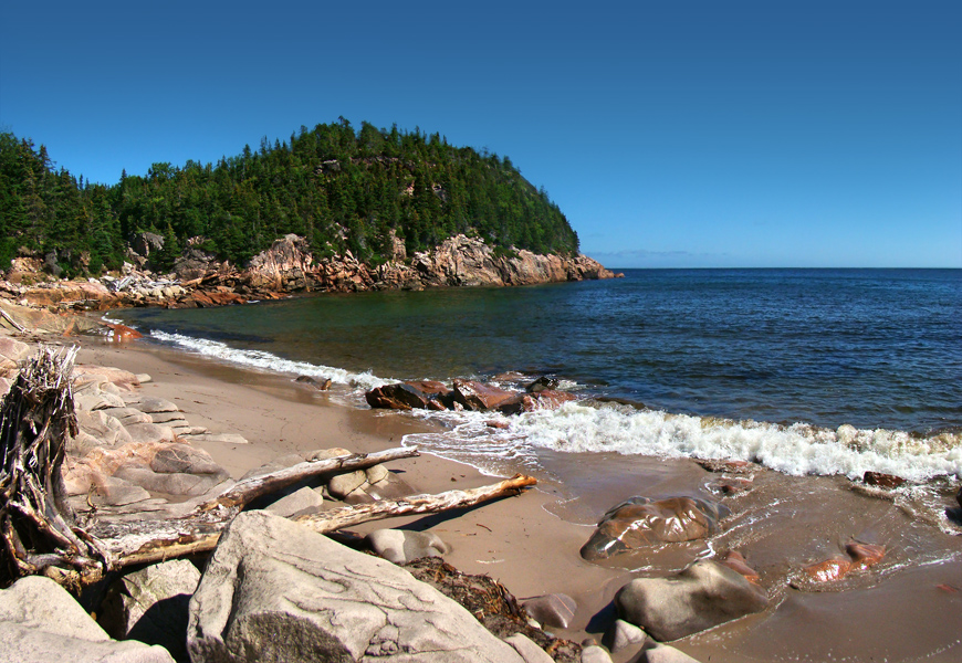
Cape Breton Highlands National Park
46.7167° N · 60.6597° W · National Park
Photo: Tango7174 · CC BY-SA 4.0 · Wikimedia Commons
Cape Breton Highlands National Park is a national park in Nova Scotia, Canada. Established in 1936 as Atlantic Canada's first national park. The free Lokali audio guide runs 7 minutes.
✓ Published October 2026 · how we write these guides
Visitor facts
| Lokali audio guide | 7 min · free |
|---|---|
| Type | National Park |
| Location | Nova Scotia, Canada |
| Coordinates | 46.7167, -60.6597 |
| Official website | pc.gc.ca |
| Languages | 50+, in the Lokali app |
The story
Listen first. Wind moves through the spruce, and far below, the sea breaks against red and grey rock. The air smells of salt, balsam, and damp moss. The road climbs in long switchbacks, and every turn opens a wider view of water. This is Cape Breton Highlands National Park, at the northern tip of Cape Breton Island in Nova Scotia. Here the land rises straight out of the ocean and then flattens into a high, windswept plateau.
The park was established in 1936. It was the first national park in Atlantic Canada. It covers roughly 950 square kilometres of forest, river canyon, bog, and coastline. On one side lies the Gulf of Saint Lawrence. On the other lies the open Atlantic. Between them, the highlands form a kind of tableland, cut deep by rivers that run down to the sea. Few places in eastern Canada put mountains and ocean this close together.
Most visitors meet the park from a car window, on the Cabot Trail. This scenic road loops around the northern part of the island, and a long stretch of it passes through the park. It is named after John Cabot, the Italian navigator who sailed for England in the late fifteenth century. Historians still debate where exactly he made landfall in North America. Cape Breton is one of the places that claims him. Either way, the name has stuck to one of the most celebrated drives on the continent.
Long before Cabot, this land was home to the Mi'kmaq, the Indigenous people of this region. In the Mi'kmaw language, Cape Breton Island is called Unama'ki, often translated as the land of fog. The Mi'kmaq fished these coasts, hunted in these forests, and travelled the rivers for thousands of years. Their name for the island is still in everyday use today. When the fog rolls in off the water, you will understand why.
Later settlers left their own marks. On the western side, near the Chéticamp entrance, the communities are Acadian, descendants of early French settlers. You may hear French spoken in the shops and cafés. Chéticamp is also known for its hooked rugs, a local folk craft passed down through families. On the eastern side, near Ingonish, the heritage is more Scottish. Highland settlers arrived from the late eighteenth century onward. Some say the rolling, misty hills reminded them of home.
That Scottish link has a small, quiet monument. Inside the park, near Pleasant Bay, stands the Lone Shieling. It is a replica of a crofter's hut, the simple stone shelter of a Scottish Highland shepherd. It sits beside a grove of old sugar maples, some of them centuries old. The forest floor there is soft and open, and the light comes down green through the leaves. It is one of the calmest places in the whole park.
Now, a surprise many visitors miss. Up on the plateau, the landscape changes completely. The tall hardwood forests of the valleys give way to stunted spruce, open bogs, and barrens. Botanists describe parts of it as taiga, the same kind of northern forest found far closer to the Arctic. Plants grow here that you would normally expect hundreds of kilometres further north. The highest point in Nova Scotia lies up on this plateau. It is not a sharp peak at all — just a gentle rise in the bog.
The forests lower down belong to what Canadians call the Acadian forest. It is a mix of hardwoods like maple, birch, and beech, with conifers such as spruce and fir. This mix is why the park is famous in autumn. Usually in early October, the hillsides turn red, orange, and gold. The evergreens stay dark, so the colours appear in patches against deep green. If you are here in the fall, the drive changes almost by the hour as the light shifts.
The animals here are part of the experience. Moose are common, and you may see one standing in a roadside ditch or a bog. Here is a second surprise. The moose you see today are largely descended from animals brought in from western Canada in the mid twentieth century. The original population on the island had disappeared. Black bears, bald eagles, and coyotes also live here. Offshore, pilot whales and minke whales often feed close to the cliffs in summer.
The park's best-known walk is the Skyline Trail, on the western side. It crosses a forested plateau and ends on a long boardwalk. The boardwalk steps down a headland toward the edge of the cliff, high above the Gulf of Saint Lawrence. From there, you look straight down the coast as the Cabot Trail winds along the mountainside. On calm days, people stand quietly and scan the water for whales. It is a place where the scale of the land becomes clear.
On the eastern side, the mood is different. Around Ingonish, the coast is softer, with coves and long beaches. At Ingonish Beach, a bar of sand and stones separates the cold ocean from a freshwater lake. You can swim in salt water and fresh water within a short walk. Nearby, Middle Head reaches out into the sea, with a trail through spruce to the tip. Inland, waterfalls such as Mary Ann Falls drop through rocky pools in the woods.
A few practical thoughts. The weather here changes fast. Fog can cover a viewpoint in minutes and lift just as quickly. Bring layers, even in summer, because the plateau is cooler and windier than the coast. Watch for wildlife on the road, especially at dawn and dusk. On trails, keep your distance from animals and keep children close. The park has many shorter walks, so you do not need to be a serious hiker to see its best sides.
Before you move on, take a moment where you are. Notice the colour of the water — often a deep blue-green below the cliffs. Notice the smell of the spruce, and the sound of the wind across the barrens. This land has been shaped by ice, by sea, and by the people who made a life on its edges. As you drive on along the trail, look back once at the headlands. They will still be here, holding the edge of the island against the sea.
Key facts
What to look for
Practical tips
Common questions
Is there a free audio guide to Cape Breton Highlands National Park?
Yes — the Lokali app narrates Cape Breton Highlands National Park free of charge in 50+ languages. The guide runs about 7 minutes, covers the history, what to look for on site and practical tips, and works offline once downloaded.
Where is Cape Breton Highlands National Park?
Cape Breton Highlands National Park is in Nova Scotia, Canada, at 46.7167, -60.6597. Tap the map link on this page for directions from where you are.
What is Cape Breton Highlands National Park known for?
Established in 1936 as Atlantic Canada's first national park. Covers roughly 950 square kilometres of northern Cape Breton.
What should you look for at Cape Breton Highlands National Park?
The Skyline Trail boardwalk stepping down the headland. The Lone Shieling stone hut beside old sugar maples. Stunted spruce and open bogs on the high plateau.
What should you know before visiting Cape Breton Highlands National Park?
Drive the Cabot Trail clockwise for ocean-side views on the west. Bring warm layers; the plateau is cooler than the coast.
When is the best time to visit Cape Breton Highlands National Park?
Walk the Skyline Trail near sunset for whale-watching light.
On the map
Opens directions to Cape Breton Highlands National Park from your location.
Hear Cape Breton Highlands National Park in your language
The full story, narrated, in 50+ languages. Download it before you go and it plays offline, at your own pace, with no ticket and no tour group.