
Ao Phang Nga National Park
8.2619° N · 98.4985° E · National Park
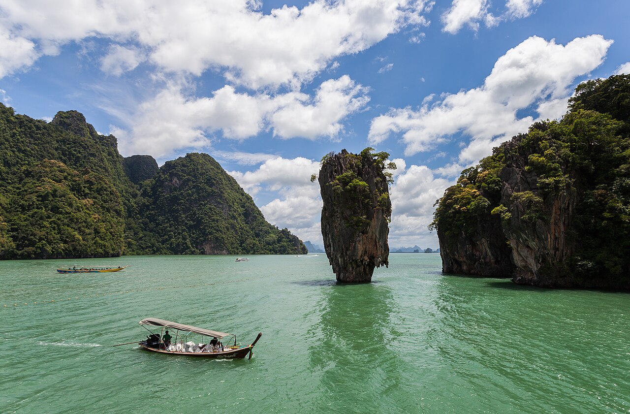
Photo: Diego Delso · CC BY-SA 3.0 · Wikimedia Commons
Ao Phang Nga National Park is a national park in southern Thailand. It is in Phang Nga, Thailand. Declared a Thai national park in 1981. The free Lokali audio guide runs 7 minutes.
✓ Published October 2026 · how we write these guides
Visitor facts
| Lokali audio guide | 7 min · free |
|---|---|
| Type | National Park |
| Location | Phang Nga, Thailand |
| Coordinates | 8.2619, 98.4985 |
| Official website | thainationalparks.com |
| Languages | 50+, in the Lokali app |
The story
Listen first. The long-tail boat engine drops to a low rattle, and the water around you turns the colour of green tea. Somewhere ahead, a cliff of grey and orange limestone rises straight out of the sea. Its base is worn into a deep notch, like a bite taken out by the tide. The air smells of salt, warm mud, and diesel. Welcome to Ao Phang Nga, the Bay of Phang Nga, on Thailand's Andaman coast.
The park was declared a national park in 1981. It protects a wide, shallow bay scattered with dozens of limestone islands. Some are hardly bigger than a house. Others rise hundreds of metres, with sheer walls and green tops. Between them, the water stays calm for much of the year. It is sheltered from the open sea by the mainland to the north and by the large island of Phuket to the west.
So where did these towers come from? This is karst country. Karst is the name geologists give to landscapes carved out of limestone by water. The rock here formed long ago from the shells and skeletons of sea creatures, laid down layer by layer on an ancient seabed. Later, the land rose, and rain slowly dissolved the softer parts. What remained are the hard pillars you see today. Then the sea level rose again, and flooded the valleys between them.
Look closely at the base of any cliff as you pass. That deep horizontal groove is the tide line at work. Salt water, waves, and tiny marine organisms eat into the rock, a little every day. Over time, the notch gets deeper, and the cliff above starts to overhang. In places, stalactites hang from these overhangs right above the waterline. They formed inside caves that have since collapsed or opened to the sky.
Here is something most visitors miss. Many of these islands are hollow. Inside, hidden from the outside, are enclosed lagoons that locals call hong — the Thai word for room. The only way in is through low sea caves, and only at the right tide. Paddlers in inflatable canoes lie back and slide under the rock. Then the ceiling lifts, and they find themselves in a quiet chamber open to the sky, ringed by walls of vines.
Now turn your attention to the shoreline of the mainland. The edges of the bay are thick with mangrove forest. Mangroves are trees that grow in salt water, standing on tangled roots like stilts. These forests are among the most extensive remaining in Thailand. They act as a nursery for fish, crabs, and shrimp. At low tide, watch the mud. Mudskippers — small fish that can breathe air — hop between the roots, and fiddler crabs wave a single oversized claw.
The bay is not only wild. People have lived among these islands for a very long time. On several cliffs, including at a site called Khao Khian, there are ancient rock paintings in red and black. They show figures of people, animals, and fish. Their exact age is debated, but archaeologists consider them prehistoric. Whoever painted them knew this water well, and depended on it for food, just as many families here still do.
For a living example, look for Koh Panyee. It is a fishing village built almost entirely on wooden stilts, in the shadow of a tall limestone rock. Its community is Muslim, and you will see the golden dome of its mosque above the rooftops. Local tradition says the village was founded by seafaring families from Java, in present-day Indonesia, who settled here generations ago. Today, its narrow plank walkways are full of seafood restaurants, small shops, and children on bicycles.
There is a lovely story from Koh Panyee, and it is true. In the 1980s, a group of village boys wanted to play football. But there was no flat land at all — only rock and water. So they built their own pitch, nailing together old planks and floating rafts. The ball often fell into the sea, and the boys learned to play fast and precise. Their team went on to compete well on the mainland, and the floating pitch still stands.
Of course, many boats here are heading for one particular place. Khao Phing Kan is a pair of leaning limestone cliffs with a small beach between them. Just offshore stands Ko Tapu, a narrow pillar of rock that seems to balance on a thin base. Its name means nail island. In 1974, these islands appeared in the James Bond film The Man with the Golden Gun. Ever since, most people simply call this spot James Bond Island.
That fame brought crowds, and the crowds brought problems. Ko Tapu is fragile, and its narrow base is slowly being eroded by the sea. For this reason, boats are no longer allowed to go right up to it. You can still see it clearly from the beach at Khao Phing Kan. Around midday, the beach can be very busy. Go early, or let your eyes drift to the quieter islands behind it.
As you travel, notice how the bay changes with the light. In the morning, a soft haze often hangs over the water, and the islands look like layers of grey paper. By noon, the sun turns the cliffs bright orange and white, streaked with black where rainwater runs down. In the late afternoon, the shadows get long, and the green water darkens. Fishermen in small boats head home, often with nets heaped in the bow.
Before you leave, take a moment to be still. Let the boat drift if you can. Listen to the water slapping against the rock, the calls of birds high on the cliffs, and the distant engine of another boat. Run your eyes along the nearest island, from its notched base up to its green crown. This shape took an unimaginably long time to form. And right now, quietly, the sea is still at work on it.
Key facts
What to look for
Practical tips
Common questions
Is there a free audio guide to Ao Phang Nga National Park?
Yes — the Lokali app narrates Ao Phang Nga National Park free of charge in 50+ languages. The guide runs about 7 minutes, covers the history, what to look for on site and practical tips, and works offline once downloaded.
Where is Ao Phang Nga National Park?
Ao Phang Nga National Park is in Phang Nga, Thailand, at 8.2619, 98.4985. Tap the map link on this page for directions from where you are.
What is Ao Phang Nga National Park known for?
Declared a Thai national park in 1981. Hong is the Thai word for room.
What should you look for at Ao Phang Nga National Park?
Deep tidal notches cut into every cliff base. Stalactites hanging just above the waterline. Golden mosque dome rising above Koh Panyee.
What should you know before visiting Ao Phang Nga National Park?
Start early to reach Khao Phing Kan before crowds. Book sea canoe trips that match the tide.
When is the best time to visit Ao Phang Nga National Park?
Start early to reach Khao Phing Kan before crowds.
On the map
Opens directions to Ao Phang Nga National Park from your location.
More to see near Ao Phang Nga National Park


Hear Ao Phang Nga National Park in your language
The full story, narrated, in 50+ languages. Download it before you go and it plays offline, at your own pace, with no ticket and no tour group.