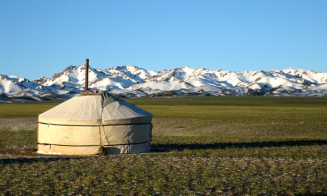
Gobi Gurvansaikhan National Park
43.8027° N · 101.5897° E · National Park
Photo: The original uploader was Adagio at English Wikipedia. (Original text: Adagio) · CC BY-SA 3.0 · Wikimedia Commons
Gobi Gurvansaikhan National Park is a national park of Mongolia. Established in 1993 as Mongolia's largest national park. The free Lokali audio guide runs 6 minutes.
✓ Published October 2026 · how we write these guides
Visitor facts
| Lokali audio guide | 6 min · free |
|---|---|
| Type | National Park |
| Location | Province of Umnugobi, Mongolia |
| Coordinates | 43.8027, 101.5897 |
| Languages | 50+, in the Lokali app |
The story
Listen first. Out here the wind does most of the talking. It moves across gravel plains, through thin tufts of grass, and over stone that has been baked and frozen for longer than anyone can count. The air smells of dust and, if you crouch down, of wild herbs. The sky is enormous. The horizon is so far away that a single camel on a distant rise can look like a small dark mark on the edge of the world.
You are standing in Gobi Gurvansaikhan National Park, in Mongolia's South Gobi province, known in Mongolian as Umnugobi. This is the largest national park in the country. It was established in 1993, a few years after Mongolia's peaceful turn to democracy, and it was later enlarged. The park does not protect one sight. It protects a whole system of mountains, canyons, dunes and steppe, where very little rain falls and life has learned to wait.
The name holds a small poem. Gurvan Saikhan means the Three Beauties. It refers to a mountain range that runs through the park in three ridges, known locally as the Eastern, Middle and Western Beauty. From the flat plains they look like dark waves of rock. As you come closer, they turn into folded, layered mountains, grey and rust-coloured, with dry riverbeds that cut down from the heights.
Many people imagine the Gobi as one endless sea of sand. Here is the first surprise... most of the Gobi is not sand at all. It is gravel, rock and hardy grassland. Sand dunes cover only a small part of the desert. That makes the dunes in this park even more striking when you finally see them. They rise out of the gravel like something from another landscape.
Those dunes are called Khongoryn Els. They stretch for well over a hundred kilometres along the foot of the mountains, and the tallest crests climb to several hundred metres. Locals often call them the Singing Sands. When the wind is right, or when sand slides down a steep face, the dunes make a deep humming sound. Some people compare it to a distant aircraft. Others hear something closer to a low organ note.
Climbing the dunes is slow work. Every step sinks and slips back. But from the top, the view changes the way you understand the place. On one side, golden sand. On the other, a thin green strip where streams run down from the mountains and feed small patches of grass. Herders use this green belt. Water is the reason anything lives here at all.
Now for a very different world. In the eastern part of the park lies Yolyn Am, a narrow gorge whose name refers to the lammergeier, or bearded vulture — a large bird of prey that nests on high ledges. The canyon walls close in tightly. The temperature drops. Wildflowers and small streams appear, and pikas — small, round relatives of the rabbit — dart between the rocks.
Here is the second surprise. In this desert valley, a thick sheet of ice traditionally formed in the shade of the gorge. For generations it lasted far into the summer, even while the plains outside burned in the heat. In recent years the ice has often melted earlier than it once did. Many visitors who arrive in midsummer now find only damp stone and the sound of running water.
The park carries traces of a far older world, too. Not far from here, at a place called Bayanzag, red sandstone cliffs glow in the late afternoon light. Explorers named them the Flaming Cliffs. In the 1920s, expeditions from the American Museum of Natural History, led by Roy Chapman Andrews, found fossil dinosaur eggs there. They were among the first dinosaur eggs to be recognised by scientists anywhere in the world.
The wider South Gobi region is still one of the richest fossil areas on Earth. The rocks here formed in a dry land of rivers, dunes and shallow basins. Animals that died here were sometimes buried quickly by sand, which helped preserve them. So the dust under your boots belongs to a story that is tens of millions of years long.
Life in the park today is just as remarkable, though much harder to see. The high ridges are home to argali, the world's largest wild sheep, and to Siberian ibex with long curved horns. Snow leopards also live in these mountains. They are so secretive that most herders go a lifetime with only a few glimpses. Golden eagles and vultures ride the warm air above the cliffs.
People live here as well. The park is not an empty wilderness fenced off from human life. Herding families move with their animals between seasonal camps, living in gers, the round felt tents of Mongolian nomads. Their two-humped Bactrian camels, goats, sheep and horses graze across the plains. If you are invited into a ger, you may be offered milk tea, salty and warm, poured from a large kettle.
Before you move on, take one more look around you. Notice the colour of the ground, the shape of the nearest ridge, the way the light changes on the rock as clouds pass. Listen again for the wind. This place has been shaped by heat, frost, water and time... and by people who have learned to read it carefully. Walk slowly, leave little behind, and let the silence stay with you for a while.
Key facts
What to look for
Practical tips
Common questions
Is there a free audio guide to Gobi Gurvansaikhan National Park?
Yes — the Lokali app narrates Gobi Gurvansaikhan National Park free of charge in 50+ languages. The guide runs about 6 minutes, covers the history, what to look for on site and practical tips, and works offline once downloaded.
Where is Gobi Gurvansaikhan National Park?
Gobi Gurvansaikhan National Park is near Province of Umnugobi, Mongolia, at 43.8027, 101.5897. Tap the map link on this page for directions from where you are.
What is Gobi Gurvansaikhan National Park known for?
Established in 1993 as Mongolia's largest national park. Gurvan Saikhan means the Three Beauties in Mongolian.
What should you look for at Gobi Gurvansaikhan National Park?
Thin green strip of grass along the base of the dunes. Small round pikas darting between rocks in Yolyn Am. Layered red sandstone faces of the Flaming Cliffs.
What should you know before visiting Gobi Gurvansaikhan National Park?
Climb the dunes early morning before the sand gets hot. Carry plenty of water and sun protection on every outing.
When is the best time to visit Gobi Gurvansaikhan National Park?
Visit Bayanzag in late afternoon for the warmest light.
On the map
Opens directions to Gobi Gurvansaikhan National Park from your location.
Hear Gobi Gurvansaikhan National Park in your language
The full story, narrated, in 50+ languages. Download it before you go and it plays offline, at your own pace, with no ticket and no tour group.