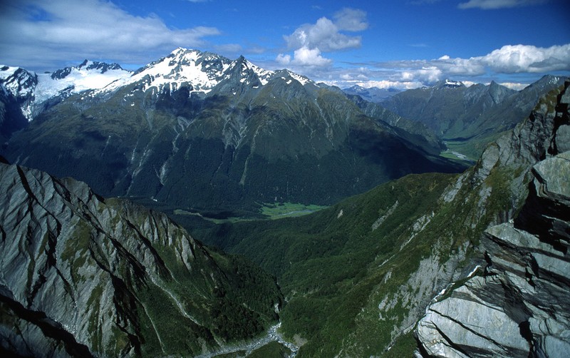
Mount Aspiring National Park
44.3828° S · 168.7328° E · National Park
Photo: en:user:Psychoticfish · Public domain · Wikimedia Commons
Mount Aspiring National Park is a national park in New Zealand. Declared a national park in 1964. The free Lokali audio guide runs 7 minutes.
✓ Published October 2026 · how we write these guides
Visitor facts
| Lokali audio guide | 7 min · free |
|---|---|
| Type | National Park |
| Location | Queenstown-Lakes, New Zealand |
| Coordinates | -44.3828, 168.7328 |
| Languages | 50+, in the Lokali app |
The story
Listen for a moment. Under the wind there is water, always water. Meltwater drips from a hanging glacier, a braided river grinds gravel against gravel, and a waterfall drops down a cliff of dark schist. Then, quite suddenly, a sharp whistle comes from the rocks above. That is a kea, the alpine parrot of New Zealand. It is probably watching you, and it is probably curious about your backpack.
You are standing in Mount Aspiring National Park, one of the large wild spaces of New Zealand's South Island. It was made a national park in 1964. Today it covers more than 3,500 square kilometres of mountains, glaciers, river valleys and beech forest. It stretches along the Southern Alps, between the lakes of the Queenstown-Lakes District and the wet, green West Coast. Most visitors enter from the town of Wānaka, or along the highway over Haast Pass.
The park takes its name from its highest peak. Mount Aspiring rises a little over three thousand metres. It is the tallest mountain in New Zealand outside the Aoraki Mount Cook region. Its Māori name is Tititea, which is usually translated as the glistening peak. On a clear day you can understand why. The summit is a steep pyramid of rock and ice, and it catches the light long after the valleys below have fallen into shadow.
Here is something many visitors miss. This park is not a separate island of protection. It is one part of Te Wāhipounamu, a World Heritage Area in the south-west of New Zealand. That name means the place of greenstone. The World Heritage Area joins this park with Fiordland, Westland and Aoraki Mount Cook. Together they form one continuous wilderness, recognised by UNESCO in 1990 for its landscapes and its living ecosystems.
That word, greenstone, matters here. Long before European explorers arrived, Māori travelled through these mountains. They searched for pounamu, a hard green stone used for tools, weapons and treasured ornaments. Routes through the passes connected the inland lakes with the West Coast, where pounamu could be found. When you drive or walk over Haast Pass today, you follow a line through the mountains that people used for centuries before the road existed.
Look now at the shape of the land around you. These valleys were carved by ice. Glaciers once filled them from wall to wall, and they left behind wide, flat valley floors with steep sides. The rock is mostly schist, a layered stone that splits into thin, shining plates. Pick up a small piece by the river and tilt it toward the sun. You will often see a silver shimmer, made by tiny flakes of mica inside the stone.
The most visited corner of the park is the Matukituki Valley, at the end of a long gravel road from Wānaka. Cattle and sheep graze the lower flats, because farmland runs right up to the park boundary. It is an unusual sight. One moment you pass a woolshed and a fence line. The next moment, glaciers hang above you on the valley walls. From here, the walk to the Rob Roy Glacier climbs through forest to a view of ice and falling water.
That forest is mostly beech. New Zealand has several kinds of native beech, and you will see silver, red and mountain beech in different parts of the park. The trees have small leaves and dark, twisted trunks. Many trunks are coated in green moss and grey lichen. In some seasons, a black sooty layer covers the bark, and tiny drops of sweet honeydew shine on the trunks. Insects produce this honeydew, and birds and bees feed on it.
The birds are a second surprise. Besides the kea, this park shelters some of New Zealand's rarer species. The whio, or blue duck, lives on fast, clear rivers, and its call sounds like a whistle. The mohua, a small yellow-headed bird, feeds high in the beech canopy. Up in the rocks above the bushline lives the rock wren, a tiny bird that stays in the alpine zone all year. Conservation teams work across the park to control predators like stoats and rats.
The mountains also hold a long climbing story. Mount Aspiring was first climbed in 1909, in the early days of New Zealand mountaineering. Since then it has become a classic peak for climbers, though it is never an easy one. In the Matukituki Valley, the New Zealand Alpine Club built Aspiring Hut, a solid stone shelter. Climbers and trampers still use it as a base. Tramping, by the way, is the New Zealand word for hiking.
If you come in along the Haast Pass highway, the park shows a different face. The road follows the Makarora River through dense forest. Short walks lead to Thunder Creek Falls, Fantail Falls and the Blue Pools. At the Blue Pools, the water is so clear that the river stones look close enough to touch, even where the water is deep. Large trout often hang still in the current below the swing bridge.
The weather here deserves respect. The mountains catch storms from the Tasman Sea, and rain on the western side can be very heavy. Conditions change fast, sometimes within an hour. Rivers rise quickly after rain and can become impossible to cross. That is why marked tracks use bridges, and why rangers ask walkers to check the forecast and tell someone their plans. A sunny morning in the valley is no promise for the afternoon on the ridge.
And there is one small local companion you will meet for certain. Near the rivers, especially on calm days, the sandflies arrive. These tiny black biting flies are part of life in the south-west of New Zealand. A local saying claims that a still evening by the water is their favourite dinner time. Keep moving, cover your ankles, and they become a minor nuisance rather than a major one.
Before you move on, stand still once more. Look up at the highest snow you can see, then down at the river beside you. That water was ice, high on those slopes, not long ago. Notice the cool air that flows down the valley, the smell of wet moss and stone, the quiet tick of the beech leaves. As you walk away, listen again for that sharp whistle from the rocks. The kea will still be here, long after you have gone.
Key facts
What to look for
Practical tips
Common questions
Is there a free audio guide to Mount Aspiring National Park?
Yes — the Lokali app narrates Mount Aspiring National Park free of charge in 50+ languages. The guide runs about 7 minutes, covers the history, what to look for on site and practical tips, and works offline once downloaded.
Where is Mount Aspiring National Park?
Mount Aspiring National Park is near Queenstown-Lakes, New Zealand, at -44.3828, 168.7328. Tap the map link on this page for directions from where you are.
What is Mount Aspiring National Park known for?
Declared a national park in 1964. Covers more than 3,500 square kilometres.
What should you look for at Mount Aspiring National Park?
Silver mica flakes shining in river schist. Black sooty bark with honeydew drops on beech trunks. Glaciers hanging on the upper valley walls.
What should you know before visiting Mount Aspiring National Park?
Check the mountain forecast before any walk. Carry insect repellent for sandflies near rivers.
On the map
Opens directions to Mount Aspiring National Park from your location.
Hear Mount Aspiring National Park in your language
The full story, narrated, in 50+ languages. Download it before you go and it plays offline, at your own pace, with no ticket and no tour group.