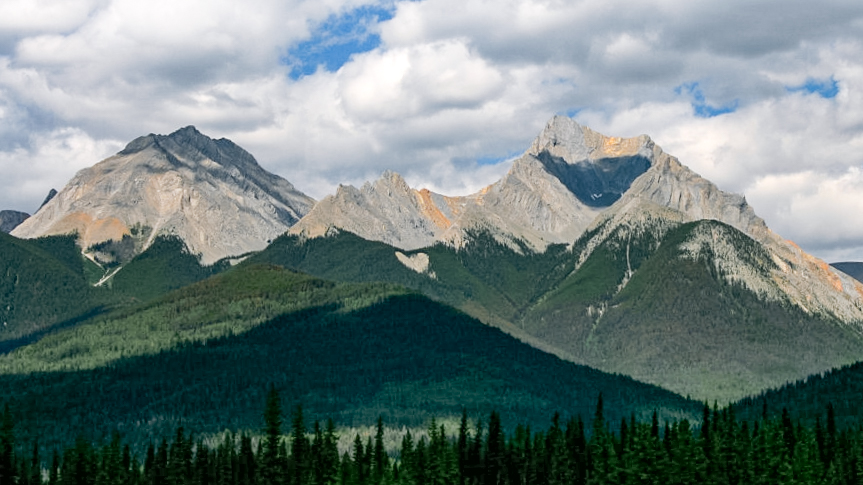
Kootenay National Park
50.8831° N · 116.0490° W · National Park
Photo: Marek Ślusarczyk (Tupungato) www.wyprawa.info · CC BY 2.5 · Wikimedia Commons
Kootenay National Park is a national park of Canada located in British Columbia. Kootenay was established as a national park in 1920. The free Lokali audio guide runs 7 minutes.
✓ Published October 2026 · how we write these guides
Visitor facts
| Lokali audio guide | 7 min · free |
|---|---|
| Type | National Park |
| Location | Regional District of East Kootenay, Canada |
| Coordinates | 50.8831, -116.0490 |
| Official website | parks.canada.ca |
| Languages | 50+, in the Lokali app |
The story
Listen first. The water at Marble Canyon is loud. It roars through a slot of grey limestone so narrow that a person could almost lean across it. Cold air rises from the gorge, even in high summer. It carries a fine mist that settles on your sleeves. Below the footbridge, the colour of the river shifts between milky turquoise and deep jade. This is the sound of Kootenay National Park, a long, narrow ribbon of mountains, canyons, and rivers on the western side of the Canadian Rockies.
The park has an unusual shape, and the shape has a reason. Kootenay runs like a corridor, following a single road through the mountains. That road is the Banff-Windermere Highway, which you may know today as Highway 93 South. In the early twentieth century, people dreamed of a motor route across the central Rockies. Building it proved slow and expensive. So British Columbia struck a deal with the federal government of Canada. The province handed over a strip of land on either side of the route, and Ottawa agreed to finish the road.
That strip of land became Kootenay National Park in 1920. The highway opened a few years later, in the early 1920s. It was celebrated as the first motor road across the central Canadian Rockies. Think about that the next time you drive it. The park exists, quite literally, because of the road. Most national parks are drawn around a landscape. This one was drawn around a journey. And the journey still shapes how almost every visitor experiences the place today.
The road climbs to Vermilion Pass, where the park meets Banff National Park. Here you cross the Continental Divide. It is a quiet line on the map, but it matters. Rain that falls on one side flows east toward Hudson Bay. Rain that falls on the other side flows west toward the Pacific Ocean. Stand at the sign for a moment. A single raindrop landing on the ridge above you could end up in either ocean, depending on a few centimetres of rock.
Around the pass, you will notice something striking. The forest is young. Thin lodgepole pines stand close together, and grey snags rise among them. This is the work of fire. A major fire burned the Vermilion Pass area in 1968, and large wildfires swept through the park again in 2003. Fire is a natural part of these forests. Lodgepole pine cones are often sealed with resin, and heat helps open them. So the burn you see is not only loss. It is also a nursery.
Now, a surprise that many drivers speed past. The rock in this park holds some of the oldest animal fossils in the world. Kootenay sits within the same geological story as the Burgess Shale, a famous fossil bed from the Cambrian period, more than five hundred million years ago. In the 2010s, researchers from the Royal Ontario Museum announced a major new fossil site in the Marble Canyon area. Soft-bodied creatures, preserved in fine detail, came out of these mountains. Access to the fossil beds is protected, and visits are by guided hike only.
Back at Marble Canyon itself, the name is a gentle mistake. The pale walls look like marble, but they are mostly limestone and dolomite. Tokumm Creek has cut this gorge over thousands of years, grinding the stone into smooth curves. A trail crosses the canyon several times on bridges. Each crossing gives you a different view straight down into the water. Look for natural arches and spots where the rock has been polished almost glassy by moving water and stones.
A short drive away lies one of the strangest places in the Rockies, the Paint Pots. Here, cold springs rich in iron bubble up through the ground. The iron stains the clay in shades of rust, orange, and deep red. These ochre beds were important to Indigenous peoples, including the Ktunaxa, who gathered the ochre and used it as a pigment. This valley lies within the traditional territories of the Ktunaxa and the Secwepemc peoples, whose connection to this land is far older than any park boundary.
The Paint Pots also carry a more recent story. In the early twentieth century, the ochre was mined commercially and shipped out to be used in paint. Along the trail, you can still find traces of that industry, including old rusting equipment left among the trees. The contrast is worth a pause. On one side, a sacred source of colour. On the other, a brief industrial episode. The ground itself still holds both, in bright red mud that clings to your boots.
Farther south, the road follows the wide valley of the Kootenay River. The mountains step back here, and the views open up. Pull over at the Kootenay Valley Viewpoint if you can. Long ranges fold into each other, layer after layer, fading from dark green to blue. In the evening, the light turns the slopes gold. Watch the meadows along this stretch. Elk, deer, and sometimes bears appear near the road, so drive slowly and keep a respectful distance.
At the southern end of the park, the landscape changes character once again. The road drops through Sinclair Canyon, between tall walls of red and orange rock. These cliffs mark a geological fault, a place where the earth has cracked and shifted. Driving through the canyon feels like passing through a gate. On the far side waits the village of Radium Hot Springs and the dry, open slopes of the Columbia Valley. Bighorn sheep are often seen in this area, sometimes standing calmly beside the road.
Just inside the canyon are the Radium Hot Springs pools. Mineral water rises from deep underground, heated by the earth. People have soaked here for generations, and the pools are now run by Parks Canada. Imagine sitting in steaming water while red cliffs rise above you and snow sits on the peaks. In cold weather, mist drifts across the surface. It is a gentle end to a long day of walking, and a reminder that the mountains hold heat as well as ice.
Wherever you are standing now, take a slow breath. Notice the smell of pine resin, or wet stone, or warm mineral water. Notice how quiet it becomes when the traffic passes. Kootenay is part of the Canadian Rocky Mountain Parks World Heritage Site, recognised by UNESCO for its mountains, glaciers, and fossils. But the best way to understand it is simple. Look at the rock beside you. It has been here for hundreds of millions of years... and it will be here long after the road is quiet.
Key facts
What to look for
Practical tips
Common questions
Is there a free audio guide to Kootenay National Park?
Yes — the Lokali app narrates Kootenay National Park free of charge in 50+ languages. The guide runs about 7 minutes, covers the history, what to look for on site and practical tips, and works offline once downloaded.
Where is Kootenay National Park?
Kootenay National Park is near Regional District of East Kootenay, Canada, at 50.8831, -116.0490. Tap the map link on this page for directions from where you are.
What is Kootenay National Park known for?
Kootenay was established as a national park in 1920. Park was created through a road-building deal with British Columbia.
What should you look for at Kootenay National Park?
Turquoise water churning far below the Marble Canyon footbridges. Rust-red and orange ochre beds bubbling at the Paint Pots. Old rusting mining equipment along the Paint Pots trail.
What should you know before visiting Kootenay National Park?
Walk the short Marble Canyon trail to cross the gorge repeatedly. Book a guided hike in advance to visit the fossil beds.
On the map
Opens directions to Kootenay National Park from your location.
More to see near Kootenay National Park

Hear Kootenay National Park in your language
The full story, narrated, in 50+ languages. Download it before you go and it plays offline, at your own pace, with no ticket and no tour group.