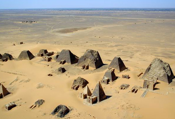
Photo: Photographer: B N Chagny · CC BY-SA 1.0 · Wikimedia Commons
Meroë is an ancient city from Nubia along the eastern bank of the Nile River in Northern Sudan. Meroë served as the Kushite royal capital for several centuries. The free Lokali audio guide runs 7 minutes.
✓ Published October 2026 · how we write these guides
Visitor facts
| Lokali audio guide | 7 min · free |
|---|---|
| Type | Archaeological Site |
| Location | River Nile, Sudan |
| Coordinates | 16.9351, 33.7507 |
| Languages | 50+, in the Lokali app |
The story
Listen first. Out here the loudest sound is often the wind, pushing fine orange sand against the stone. Underfoot the ground is soft and shifting, and each step sinks a little. Ahead of you, on a low ridge, a line of dark pyramids rises from the dunes. They are narrow and steep, and they stand close together like a crowd frozen in place. This is Meroë, in the desert of northern Sudan, on the east side of the Nile.
Many visitors arrive expecting something like Giza. That is not what they find. These pyramids are much smaller, and their sides are far steeper. Most stand only a few storeys tall. The angle is sharp, almost needle-like, and that gives the whole cemetery a lean, upward energy. This was a different tradition, built by a different people. It was not a copy of Egypt, even though it borrowed from Egypt.
The people who built Meroë were the Kushites. Kush was an ancient African kingdom that grew along the middle Nile, in the land later called Nubia. For a short period in the eighth and seventh centuries before Christ, Kushite kings even ruled Egypt as pharaohs. Later, the centre of royal power shifted south to this stretch of river. Meroë became the capital, and it stayed important for several centuries, until roughly the fourth century of the common era.
Why here? The land around Meroë had advantages that are easy to miss today. It sat within reach of seasonal summer rains, so cattle could graze and crops could grow away from the river. It also sat on trade routes. Goods moved north toward Egypt and the Mediterranean world, and south and east into Africa. Ivory, gold, ebony and exotic animals passed through Kushite hands. The kingdom became wealthy, and the royal family showed that wealth in stone.
Here is the first surprise. Look closely at the low mounds of dark, glassy rubble scattered across this region. Many of them are slag — waste from smelting iron. Meroë was a major centre of iron production in the ancient world. Archaeologists have found large slag heaps near the old town. Some early scholars were so struck by them that they called Meroë the Birmingham of Africa, after the English industrial city. Iron tools and weapons likely helped power the kingdom's success.
Now walk toward the pyramids themselves. They are built of local sandstone, cut into blocks and stacked in layers. Many have a small chapel attached to the east face. These chapels were offering rooms, where the living brought food and prayers for the dead. On their walls you can still find carved reliefs. Royal figures sit on thrones. Gods receive offerings. Processions move across the stone. The burial chambers themselves lie underground, beneath the pyramids, not inside them.
And here is the second surprise. Notice how many of these pyramids have flat, broken tops. That damage is not only the work of time. In the 1830s, an Italian treasure hunter named Giuseppe Ferlini came to Meroë. He believed the pyramids held gold. He broke the tops off many of them in his search. In one tomb he did find gold jewellery, which later ended up in museums in Europe. The flattened summits you see today are partly his legacy.
The tombs here belonged to kings, and also to powerful queens. Kush had a royal title for women that the Greeks and Romans wrote as Kandake, or Candace. Some of these women ruled in their own right. Classical writers mention a Kandake who led Kushite forces against Roman troops in Egypt. Reliefs from Meroitic sites show queens as large, strong figures, sometimes holding weapons. In this kingdom, female rulers were not a rare exception. They were part of the system.
The Kushites also had their own writing. It is called Meroitic, and it came in two forms — one based on Egyptian hieroglyphs, and one in a flowing cursive. Scholars can read the sounds of the letters. But the language itself is still largely not understood. Imagine that for a moment. Inscriptions stand all around these sites, and experts can pronounce many of the words, yet much of their meaning stays out of reach. It is one of the great unsolved puzzles of the ancient world.
The pyramids are only part of Meroë. Closer to the river lie the remains of the Royal City. Excavations there uncovered palaces, temples and a structure often called the Royal Baths, with water channels and decoration. There was also a large temple to Amun, the Egyptian god whom the Kushites honoured deeply. Today much of the city is low walls and scattered stone. It needs more imagination than the pyramids, but it shows that Meroë was a living town, not just a cemetery.
In 2011, UNESCO listed the Archaeological Sites of the Island of Meroë as World Heritage. The so-called island is not surrounded by water on all sides. It is a stretch of land between the Nile and the Atbara River. The listing also includes two other Kushite sites in the desert nearby, Naqa and Musawwarat es-Sufra. Together they show temples, reservoirs and ceremonial spaces far from the river, built where the seasonal rains made life possible.
Today the setting is very quiet. You may see a few local camel handlers waiting near the dunes, or a small group of visitors climbing slowly over the sand. There are no crowds here, and no city noise. The light changes the colour of everything. In the early morning the sand looks pale gold. Late in the afternoon it turns deep orange, and the pyramids throw long, sharp shadows down the slope. The heat can be strong, so the edges of the day feel gentlest.
Before you leave, stand still for a moment between two of the pyramids. Feel how the wind moves through the gaps between them. Look at the carved figures on the nearest chapel wall, worn soft by sand and sun. Then look east, out across the empty desert, the same view these rulers chose for their eternal rest. As you walk back down the ridge, listen again. The wind is still moving the sand, just as it has for more than two thousand years.
Key facts
What to look for
Practical tips
Common questions
Is there a free audio guide to Meroë?
Yes — the Lokali app narrates Meroë free of charge in 50+ languages. The guide runs about 7 minutes, covers the history, what to look for on site and practical tips, and works offline once downloaded.
Where is Meroë?
Meroë is near River Nile, Sudan, at 16.9351, 33.7507. Tap the map link on this page for directions from where you are.
What is Meroë known for?
Meroë served as the Kushite royal capital for several centuries. Kushite kings once ruled Egypt as pharaohs.
What should you look for at Meroë?
Flattened pyramid tops broken by nineteenth-century treasure hunters. Small offering chapels attached to the eastern pyramid faces. Carved reliefs of enthroned royals on the chapel walls.
What should you know before visiting Meroë?
Check current travel advisories for Sudan before planning any visit. Visit early morning or late afternoon to avoid peak heat.
When is the best time to visit Meroë?
Visit early morning or late afternoon to avoid peak heat.
On the map
Opens directions to Meroë from your location.
Hear Meroë in your language
The full story, narrated, in 50+ languages. Download it before you go and it plays offline, at your own pace, with no ticket and no tour group.