Channel Islands National Park
33.6600° N · 119.6400° W · National Park
Photo: The original uploader was Rmhermen at English Wikipedia. · Public domain · Wikimedia Commons
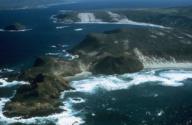
Channel Islands National Park is a national park of the United States. The park protects five islands and surrounding ocean waters. The free Lokali audio guide runs 8 minutes.
✓ Published October 2026 · how we write these guides
Visitor facts
| Lokali audio guide | 8 min · free |
|---|---|
| Type | National Park |
| Location | Santa Barbara County, United States |
| Coordinates | 33.6600, -119.6400 |
| Official website | nps.gov |
| Languages | 50+, in the Lokali app |
The story
Listen first. Gulls cry overhead, and the boat engine slows to a low hum. Salt spray settles on your sleeves. Ahead, cliffs of dark volcanic rock rise straight out of the Pacific. They are streaked white by seabirds and topped with dry golden grass. The water below is a deep, cold blue, sometimes almost green where the kelp grows thick. Behind you, the coast of Southern California is a hazy line. Ahead is a world that has been shaped by its own isolation.
Welcome to Channel Islands National Park. The park protects five islands off the coast of Santa Barbara and Ventura counties. Their names are Anacapa, Santa Cruz, Santa Rosa, San Miguel, and Santa Barbara. The park also protects the ocean around them, out to one nautical mile from each shore. Two of the islands became a national monument in 1938. Congress made the whole group a national park in 1980. Today, it is one of the least visited national parks in the country. Most people simply never cross the channel.
That channel is the reason this place is so unusual. The islands sit only a short boat ride from millions of people. Yet the water has kept them apart from the mainland for a very long time. Plants and animals that arrived here were cut off. Over thousands of years, many of them changed. Some became smaller. Some became found nowhere else on Earth. Scientists sometimes call these islands the Galápagos of North America. The comparison is not perfect, but it points to the same idea — evolution working quietly on isolated land.
The best example is the island fox. It lives only on the Channel Islands, and it is smaller than many house cats. Each of the larger islands has its own subspecies. Here is the surprise — in the late 1990s, the fox nearly disappeared. Golden eagles had moved onto the islands, and they hunted the foxes heavily. On some islands, only a handful of foxes survived. A major recovery effort followed, with captive breeding and the removal of eagles. Today, the foxes have returned in strong numbers, and they were removed from the endangered species list in 2016.
If you visit Santa Cruz, watch for a bright blue bird with a loud, harsh call. This is the island scrub-jay. It lives only on Santa Cruz Island and nowhere else in the world. It is larger and more brightly coloured than its relatives on the mainland. Birdwatchers travel here specifically to see it. Santa Cruz is the largest island in the park, and also the largest island in California. Its landscape includes mountains, valleys, and long canyons that run down to the sea.
Long before the national park, these islands were home to people. The Chumash, a Native American people of this coast, lived here for thousands of years. They built plank canoes called tomols. These boats were made from wooden planks, sewn together and sealed with natural tar. In these canoes, the Chumash crossed the channel to trade and to fish. The Chumash name for Santa Cruz Island is Limuw. Chumash communities are still active on the mainland today, and some of them paddle tomols across the channel again.
The human story here goes back further than most people expect. On Santa Rosa Island, researchers found human remains known as Arlington Springs Man. They are about 13,000 years old. They are among the oldest known human remains in North America. This discovery supports an important idea — that some of the earliest people in the Americas may have travelled along the coast, perhaps by boat. Santa Rosa holds another surprise. Fossils of pygmy mammoths have been found there. These were small descendants of the larger mammoths that once lived on the mainland.
Now let us move closer to shore. Anacapa is the nearest island to the mainland. In fact, it is a chain of three small islets. On its eastern end, you may see a natural rock arch standing in the sea. It is one of the most photographed features in the park. A lighthouse stands on the clifftop above, built in the 1930s. In spring, the island is a nesting ground for thousands of western gulls. The air fills with their calls, and the ground is dotted with nests, eggs, and fluffy grey chicks.
Anacapa is also important for the California brown pelican. West Anacapa is a key nesting area for this large seabird. In the middle of the twentieth century, pesticide pollution made pelican eggshells too thin to survive. Their numbers dropped sharply. After those chemicals were banned, the pelicans slowly recovered. Seeing them glide low over the water here is a small sign of that recovery. Parts of West Anacapa are closed to protect them, so you watch from a respectful distance.
Below the surface, the park is just as alive. Forests of giant kelp grow in the cold, nutrient-rich water. They rise from the seafloor toward the light, and they shelter fish, sea stars, and sea urchins. Look for the bright orange garibaldi, California's state marine fish. Sea lions and harbour seals rest on the rocks. In some seasons, whales pass through the channel. Many visitors see dolphins from the boat on the way out. Several marine reserves inside the park protect parts of this underwater world from fishing.
The coastline is also full of sea caves. Santa Cruz has many of them, carved by waves into volcanic rock. One of the best known is Painted Cave, on the island's northwest shore. It is considered one of the largest sea caves in the world. Its name comes from the colours on its walls — lichens, algae, and different layers of rock. Kayaking near the caves is a popular way to explore, but conditions change quickly. Most visitors go with a licensed guide.
Visiting these islands takes some planning. There are no shops or restaurants on the islands, and services are very limited. You bring your own food and water, and you take your rubbish back with you. Boats leave from harbours in Ventura and Oxnard, and some visitors fly to the outer islands. Many people begin at Scorpion Anchorage on Santa Cruz, where trails climb into the hills. Weather and sea conditions can cancel trips, so flexibility helps. The reward is real quiet, with no traffic and very few people.
So take a moment, wherever you are standing. Notice the wind, which almost never stops out here. Notice the smell of salt and dry sage. Look back toward the mainland and its long, crowded coast. Then look at the land under your feet — land that has followed its own path for thousands of years. When you leave, watch the water as the islands grow smaller behind you. You may see a pelican, a dolphin, or simply the light on the waves.
Key facts
What to look for
Practical tips
Common questions
Is there a free audio guide to Channel Islands National Park?
Yes — the Lokali app narrates Channel Islands National Park free of charge in 50+ languages. The guide runs about 8 minutes, covers the history, what to look for on site and practical tips, and works offline once downloaded.
Where is Channel Islands National Park?
Channel Islands National Park is near Santa Barbara County, United States, at 33.6600, -119.6400. Tap the map link on this page for directions from where you are.
What is Channel Islands National Park known for?
The park protects five islands and surrounding ocean waters. Became a national park in 1980.
What should you look for at Channel Islands National Park?
The natural rock arch off Anacapa's eastern tip. Bright blue island scrub-jays in Santa Cruz oak trees. Small island foxes trotting near campgrounds and trails.
What should you know before visiting Channel Islands National Park?
Bring all food and water; islands have no shops. Pack layers because channel wind stays strong and cold.
On the map
Opens directions to Channel Islands National Park from your location.
Hear Channel Islands National Park in your language
The full story, narrated, in 50+ languages. Download it before you go and it plays offline, at your own pace, with no ticket and no tour group.