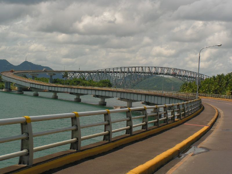
San Juanico Bridge
11.3028° N · 124.9719° E · Bridge
Photo: byron alcantara from Fredon, United States · Public domain · Wikimedia Commons
San Juanico Bridge is a long truss bridge in the Philippines. The bridge links the islands of Samar and Leyte. The free Lokali audio guide runs 7 minutes.
✓ Published October 2026 · how we write these guides
Visitor facts
| Lokali audio guide | 7 min · free |
|---|---|
| Type | Bridge |
| Location | Santa Rita, Philippines |
| Coordinates | 11.3028, 124.9719 |
| Languages | 50+, in the Lokali app |
The story
Feel the wind first. Out here, at the Santa Rita end, it comes straight off the water, warm and salty, and it carries the low hum of tyres on steel. Below you, the sea moves in slow green coils between small, wooded islands. Above you, a line of pale blue-grey trusses runs away toward the far shore, rising and falling like a row of shoulders. This is the San Juanico Bridge, and you are standing on the island of Samar.
Look across to the other side. That shore is Leyte, and the city you can see in the distance is Tacloban. Between the two islands runs the San Juanico Strait. It is a narrow, winding channel, and for most of human history people crossed it by boat. Fishermen, traders and families moved back and forth in small craft. The current here can be strong. The bridge you see today replaced all of that with a single road.
The numbers are simple, and they are worth holding in your head. The bridge is a little over two kilometres long, roughly 2,160 metres from end to end. That makes it the longest bridge in the Philippines that crosses a body of seawater. It was completed in the early 1970s, and it opened in 1973. For a country made of more than seven thousand islands, a fixed road link between two of them was a real event.
The bridge carries part of the Pan-Philippine Highway, the long road that links the main islands of the archipelago. Trucks, buses, jeepneys and motorbikes use it every day. So when you watch the traffic roll past, you are not only watching local commuters. You are watching a section of a national route that runs from the north of the country toward the south. Rice, fish, copra and passengers all move across this steel.
Now look at the shape. The bridge does not run straight. Near the Leyte side, the road bends in a long, smooth curve, almost like the letter S. Most visitors notice the steel arch over the main channel first. The curve is the detail many people miss. It lets the road meet the land at a gentle angle, and from the right viewpoint it gives the whole structure a soft, flowing outline against the hills.
The tallest section sits over the deepest part of the strait. Here the steel trusses form an arch that lifts the road high above the water. That height is not decoration. It leaves room for boats to pass underneath. Elsewhere, the road rests on a long series of concrete piers that step across the shallows. Count a few of them as your eye follows the line. The rhythm is steady, almost musical, pier after pier after pier.
There is a story that people tell about this bridge, and it is worth hearing as a story. The bridge was built during the presidency of Ferdinand Marcos. His wife, Imelda Marcos, came from Leyte. According to a popular tale, the bridge was a gift of love from the president to his wife's home province. Some locals still call it a bridge of love. Historians are more careful. They see it as part of a wider programme of large public works in that era.
That era is remembered in very different ways across the Philippines. For some people, projects like this one stand for ambition and progress. For others, they stand for a time of martial law, debt and political control. You do not need to settle that argument while you stand here. It is enough to know that the bridge carries both meanings. Ask a few people in Santa Rita or Tacloban what they think, and you may hear both.
In November 2013, this coast faced one of the strongest storms ever recorded. Super Typhoon Haiyan, known locally as Yolanda, struck the region with terrible force. Tacloban, just across the water, suffered enormous loss of life and property. The storm surge pushed the sea deep into the city. Yet the bridge remained standing. In the days that followed, it became a vital route for rescue teams, relief goods and families searching for each other.
Think about that as you look at the steel. A structure like this is built for the slow, everyday work of carrying traffic. In 2013 it also carried hope. Trucks loaded with water and food crossed here when many other roads were blocked. For people in Eastern Visayas, the bridge is not only an engineering record. It is part of the memory of that storm, and of the recovery that came after.
A bridge in salt air never rests. Wind, rain, heat and sea spray all work on steel and concrete year after year. In recent years, engineers have carried out repair and strengthening work, and at times heavy vehicles have faced limits on crossing. If you see crews, barriers or fresh paint, that is the quiet maintenance that keeps a bridge like this alive. Every bolt and every coat of paint has a job.
If you have time, walk a short way along the approach and simply watch the water. The strait is full of small islands, green with trees and edged with rock. Fishing boats move slowly between them. On calm days, the surface turns glassy and reflects the trusses. When the tide turns, you can sometimes see swirls and ripples where the current pulls through the narrow channel. Early morning and late afternoon bring softer light and fewer crowds.
Before you leave, turn around once more. Look at the long line of piers, the lifted arch, the gentle curve toward Leyte. Listen to the hum of the traffic and the slap of water on the rocks below. Two islands that were once joined only by boats are joined here by a road. As you walk away, notice how the bridge stays in view behind you... a thin grey line across the blue, still carrying people home.
Key facts
What to look for
Practical tips
Common questions
Is there a free audio guide to San Juanico Bridge?
Yes — the Lokali app narrates San Juanico Bridge free of charge in 50+ languages. The guide runs about 7 minutes, covers the history, what to look for on site and practical tips, and works offline once downloaded.
Where is San Juanico Bridge?
San Juanico Bridge is near Santa Rita, Philippines, at 11.3028, 124.9719. Tap the map link on this page for directions from where you are.
What is San Juanico Bridge known for?
The bridge links the islands of Samar and Leyte. Its length is a little over two kilometres.
What should you look for at San Juanico Bridge?
The S-shaped curve near the Leyte end. The raised steel arch over the main channel. Rows of concrete piers stepping across the shallows.
What should you know before visiting San Juanico Bridge?
Come early morning for soft light and calmer traffic. Stay on marked walkways; vehicles move fast here.
When is the best time to visit San Juanico Bridge?
Come early morning for soft light and calmer traffic.
On the map
Opens directions to San Juanico Bridge from your location.
Hear San Juanico Bridge in your language
The full story, narrated, in 50+ languages. Download it before you go and it plays offline, at your own pace, with no ticket and no tour group.