Photo: w:User:Zhang 2008 · Public domain · Wikimedia Commons
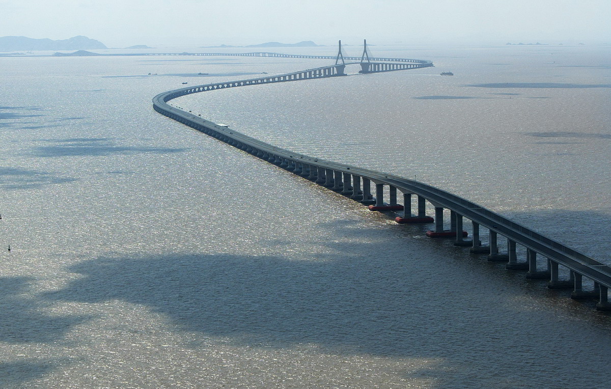
Donghai Bridge is a road bridge in Shanghai and Yangshan Port. Opened at the end of 2005 with Yangshan Port. The free Lokali audio guide runs 7 minutes.
✓ Published October 2026 · how we write these guides
Visitor facts
| Lokali audio guide | 7 min · free |
|---|---|
| Type | Bridge |
| Location | Shanghai, China |
| Coordinates | 30.7572, 121.9688 |
| Languages | 50+, in the Lokali app |
The story
Listen first. On a clear day at the southeastern edge of Shanghai, the wind comes off the sea with a steady push. It carries salt and the low, distant hum of heavy trucks. Ahead of you, a pale grey road lifts off the shore and runs straight out over the water. It keeps going until it thins into a line, and then the line simply disappears into haze. This is the Donghai Bridge, and most people who see it for the first time ask the same question. Where does it end?
The answer is an island port. The bridge links the Shanghai mainland, near the old fishing town of Luchaogang, to the Yangshan Deep-Water Port. That port sits on a cluster of small islands out in Hangzhou Bay. Here is the first surprise. Those islands are not in Shanghai at all. They belong to the neighbouring province of Zhejiang. Shanghai built one of its most important ports on land it does not govern, and it built this bridge to reach it.
Why go to all that trouble? Shanghai grew up as a river port. Its old docks lie along the Huangpu River and the mouth of the Yangtze, the longest river in China. But the Yangtze carries enormous amounts of silt. The water near the city is shallow, and the largest modern container ships need deep water to dock. By the end of the twentieth century, Shanghai faced a real problem. It was one of the busiest trading cities in the world, yet the biggest ships could not easily reach it.
The solution was bold. Engineers looked out to sea and found deep channels around the Yangshan islands, roughly thirty kilometres offshore. The plan was to build a new port there, and then build a road across open water to carry the cargo back to land. Construction on the bridge began in the early 2000s. It opened at the end of 2005, together with the first stage of the new port.
The numbers are hard to picture from the shore. The bridge runs for more than thirty kilometres across the sea. When it opened, it was one of the longest sea-crossing bridges in the world. Within a few years, other Chinese bridges overtook it, including the Hangzhou Bay Bridge just to the south. But the Donghai Bridge was among the first of this generation. In many ways, it showed that such long crossings over open sea were possible.
Now look at the shape of it. The bridge does not run in one perfect straight line. Out over the water, it bends in long, gentle curves. Engineers often design long bridges this way on purpose. A road that runs dead straight for half an hour can make drivers tired and inattentive. Soft curves keep their eyes moving and their minds alert. They also help the structure follow the best foundations on the seabed below.
That seabed was not an easy place to build. This part of the East China Sea is shallow, muddy and open to strong winds and typhoons. Workers had to drive thousands of piles deep into soft ground, often far from land. They had to protect the steel and concrete from salt water for decades of service. Much of the bridge is made from long, repeated concrete sections. If you look closely, you can see that rhythm of identical spans, one after another, marching out to sea.
Notice the colour of the water. It is not blue. Near the shore, it is a cloudy brown, the colour of milky tea. That is the Yangtze silt again, the same mud that pushed the port out to sea in the first place. Farther out, on brighter days, the water can turn grey-green. The bridge crosses the line where the great river slowly gives way to the ocean.
Here is the second surprise. Along one side of the bridge, you may see rows of tall white wind turbines standing in the sea. This is the Donghai Bridge offshore wind farm. It was China's first large offshore wind farm, and it began sending power to the grid around 2010, the year Shanghai hosted the World Expo. The bridge made construction easier, because workers and materials could reach the site by road. Today the turbines turn slowly beside the traffic, two kinds of infrastructure side by side.
In some places, the bridge rises higher above the water. These raised sections let ships pass underneath through navigation channels. At the main channel, tall towers hold the road with fans of steel cables. This design is called cable-stayed, which means the cables run straight from the towers down to the deck. From a distance, these towers are the easiest points to spot on the long grey line.
It is important to know that the Donghai Bridge is an expressway. It is not a promenade, and you cannot walk or cycle across it. Most of the vehicles are container trucks heading to and from Yangshan. If you want to cross, you will need to travel by car, coach or bus. Many visitors simply enjoy it from the shore near Luchaogang. There, a sea wall and waterfront area give you a wide view of the bridge leaving land.
The area around you is part of Lingang, a planned new district of Shanghai. Not long ago, much of this land was tidal flats and farmland. Now it has wide avenues, new apartment towers and a large, round artificial lake called Dishui Lake. The district grew partly because of the port and the bridge. In a sense, the bridge did more than carry cargo. It pulled a whole new part of the city toward the sea.
Spend a moment thinking about what crosses this bridge every day. Every container truck carries goods that may end up in shops across the world. Clothes, machines, electronics and parts all pass along this road. Yangshan has become one of the busiest container ports anywhere, and much of that trade travels over this single crossing. The quiet line on the horizon is, in fact, one of the busiest links in global trade.
Before you leave, look once more at the place where the road meets the sea. Watch a truck shrink as it drives away from the shore, smaller and smaller, until the haze takes it. Feel the wind again and listen to the low hum of traffic. Somewhere out there, beyond what you can see, the road reaches the islands and the cranes. And as you turn back toward the city, the bridge keeps running behind you, holding its long line over the water.
Key facts
What to look for
Practical tips
Common questions
Is there a free audio guide to Donghai Bridge?
Yes — the Lokali app narrates Donghai Bridge free of charge in 50+ languages. The guide runs about 7 minutes, covers the history, what to look for on site and practical tips, and works offline once downloaded.
Where is Donghai Bridge?
Donghai Bridge is in Shanghai, China, at 30.7572, 121.9688. Tap the map link on this page for directions from where you are.
What is Donghai Bridge known for?
Opened at the end of 2005 with Yangshan Port. Spans more than thirty kilometres across open sea.
What should you look for at Donghai Bridge?
Long gentle curves bending the road over water. Brown, silt-heavy water close to the shore. Rows of white wind turbines standing in the sea.
What should you know before visiting Donghai Bridge?
View the bridge from the Luchaogang shoreline sea wall. Choose a clear day, since sea haze often hides it.
On the map
Opens directions to Donghai Bridge from your location.
Hear Donghai Bridge in your language
The full story, narrated, in 50+ languages. Download it before you go and it plays offline, at your own pace, with no ticket and no tour group.