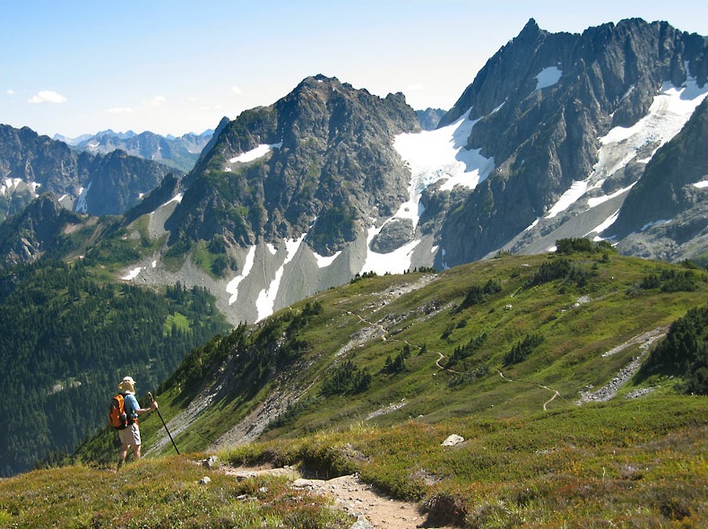
North Cascades National Park
48.4831° N · 120.9114° W · National Park
Photo: Daniel Hershman · CC BY 2.0 · Wikimedia Commons
North Cascades National Park is a U.S. National Park located in the state of Washington. Congress established the park in 1968. The free Lokali audio guide runs 6 minutes.
✓ Published October 2026 · how we write these guides
Visitor facts
| Lokali audio guide | 6 min · free |
|---|---|
| Type | National Park |
| Location | Skagit County, United States |
| Coordinates | 48.4831, -120.9114 |
| Official website | nps.gov |
| Languages | 50+, in the Lokali app |
The story
Listen first. Somewhere below you, water is moving fast over stone. The air smells of wet cedar and cold rock. Even on a warm afternoon, a chill drifts down from the high country, carried by meltwater that was snow and ice not long ago. Look up, and the peaks rise in jagged rows, sharp and grey and streaked with white. This is North Cascades National Park, a place people sometimes call the American Alps.
The name fits, but it hides something. These mountains are among the most rugged in the lower United States. They are steep and broken, cut by deep valleys. They are also heavily glaciated. The park holds several hundred glaciers. That is more than any other national park in the United States outside Alaska. Many sit high and out of sight. But their work is everywhere around you, in the shape of every valley and the colour of every lake.
Here is the first thing many visitors miss. The famous drive through this region, State Route 20, known as the North Cascades Highway, does not actually cross the national park itself. It runs through Ross Lake National Recreation Area, a corridor of land managed alongside the park. Together with Lake Chelan National Recreation Area to the south, these lands form one protected complex. The park proper lies on either side, almost entirely roadless wilderness.
That wilderness is the heart of the place. Most of the park is designated wilderness, and much of it carries the name of Stephen Mather, the first director of the National Park Service. There are no roads into the deep interior. You reach it on foot, by trail, or by boat across the lakes. As a result, this is one of the least visited national parks in the country. Its quiet is not an accident. The landscape itself keeps people at a distance.
People were here long before the park, of course. Indigenous peoples have lived in and travelled through these mountains for thousands of years. Archaeologists have found evidence of long human use, including stone tool sites in the high country. Routes such as Cascade Pass linked the wet western valleys with the drier lands to the east. Trade and travel moved across these ridges for generations before any surveyor arrived. When you walk a mountain trail here, you may be following a very old path.
The park itself is young by comparison. Congress established it in 1968, after years of debate over logging, mining, and how these mountains should be used. The highway came a few years later, opening in the early 1970s. Even now, that road closes each winter. Heavy snow and avalanches make the high passes impossible to keep open. For several months of the year, the mountains return almost completely to themselves.
Now, the colour of the water. If you have seen Diablo Lake, you have seen a shade of green that looks almost unreal. It is a milky turquoise, bright and opaque. The cause is glacial flour. As glaciers grind against bedrock, they crush stone into a powder finer than sand. Meltwater carries this powder into the lakes. The tiny particles stay suspended in the water and scatter sunlight. That is what gives the lake its glow.
Here is the second surprise. Diablo Lake is not entirely natural. Neither is Ross Lake, or Gorge Lake below them. All three are reservoirs, created by dams on the Skagit River. Seattle City Light built them during the twentieth century to send electricity to the city, more than a hundred kilometres away. So the turquoise water you photograph is glacial in colour, but it sits behind concrete. The wild and the engineered share this valley closely.
That history explains Newhalem, the small town along the highway. It began as a company town for the people who built and ran the dams. Its neat houses and quiet lawns feel unexpected in such steep country. Near the town, short trails lead through old forest. The Trail of the Cedars follows the river past tall western red cedars. Their bark is soft and fibrous, and their roots spread wide across the damp ground.
The forests here change dramatically from west to east. Storms from the Pacific Ocean drop huge amounts of rain and snow on the western slopes. That moisture feeds dense forests of cedar, hemlock, and fir, thick with moss and ferns. Cross the crest, and the air becomes drier. The trees thin out. Pine appears. In a single day's drive, you can move from something close to rainforest into open, sunlit country.
This variety of landscape supports a wide range of life. Black bears move through the valleys. Mountain goats climb the cliffs. In rock fields high up, you might hear a sharp squeak from a pika, a small round relative of the rabbit that gathers grass for winter. Along the Skagit River, bald eagles gather in winter to feed on salmon. Gray wolves have returned to parts of the North Cascades region in recent decades.
The glaciers that shaped all of this are changing. Scientists have tracked them here for many years, and most are shrinking as the climate warms. That matters well beyond the park. Glacial meltwater keeps rivers flowing in late summer, when rain is scarce. It supports salmon and feeds the reservoirs downstream. The ice you see on the far peaks is part of a system that reaches all the way to the sea.
So take a moment where you stand. Notice the colour of the water, the shape of the ridgeline, the cool air coming off the snow. Listen again for the river. That sound has carried stone and ice down this valley for a very long time. As you walk on, look at the moss on the rocks, the light on the far peaks, and the quiet that stays with this place long after the road behind you goes still.
Key facts
What to look for
Practical tips
Common questions
Is there a free audio guide to North Cascades National Park?
Yes — the Lokali app narrates North Cascades National Park free of charge in 50+ languages. The guide runs about 6 minutes, covers the history, what to look for on site and practical tips, and works offline once downloaded.
Where is North Cascades National Park?
North Cascades National Park is near Skagit County, United States, at 48.4831, -120.9114. Tap the map link on this page for directions from where you are.
What is North Cascades National Park known for?
Congress established the park in 1968. Holds the most glaciers outside Alaska.
What should you look for at North Cascades National Park?
Milky turquoise water colour caused by glacial flour. Soft, fibrous bark on old western red cedars. White glaciers clinging to the high northern faces.
What should you know before visiting North Cascades National Park?
Start at the visitor center near Newhalem for trail advice. Check road status before travelling; the highway closes in winter.
When is the best time to visit North Cascades National Park?
Check road status before travelling; the highway closes in winter.
On the map
Opens directions to North Cascades National Park from your location.
Hear North Cascades National Park in your language
The full story, narrated, in 50+ languages. Download it before you go and it plays offline, at your own pace, with no ticket and no tour group.