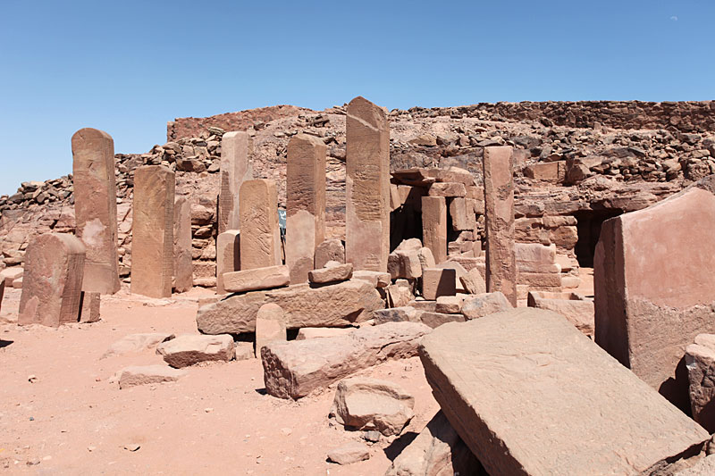
Serabit el-Khadim
29.0367° N · 33.4594° E · Archaeological Site
Photo: Roland Unger · CC BY-SA 3.0 · Wikimedia Commons
Serabit el-Khadim is an archaeological site in southwestern Sinai. It is near South Sinai, Egypt. Ancient Egyptians mined turquoise here for many centuries. The free Lokali audio guide runs 7 minutes.
✓ Published October 2026 · how we write these guides
Visitor facts
| Lokali audio guide | 7 min · free |
|---|---|
| Type | Archaeological Site |
| Location | South Sinai, Egypt |
| Coordinates | 29.0367, 33.4594 |
| Languages | 50+, in the Lokali app |
The story
The last stretch of the climb is loose stone, pale and sharp, and every step lands with a small dry crunch. The wind up here carries almost no smell at all, only dust and heat. Then the plateau opens out in front of you, and you see them: tall slabs of stone standing upright across the summit, like the masts of ships that sank into the rock. This is Serabit el-Khadim, high in the mountains of southwest Sinai.
The name comes from Arabic, and it is usually translated as something like 'the heights of the servant' or 'the heights of the slave'. The local Bedouin gave the place that name long after its builders had gone. But the builders themselves were Egyptians, and they came here for one reason. They came for a blue-green stone that they valued very highly. They came for turquoise, and the hills around you still carry the scars of their work.
To understand this place, picture the journey the ancient miners made. Egypt sits across the Gulf of Suez, to the west. Expeditions crossed the water, then travelled inland through dry valleys to reach these mountains. They brought officials, scribes, soldiers, stonecutters and labourers. They also brought donkeys, food and water, because the plateau gives very little of its own. Each expedition was an organised state project. Many of them left a written record of their visit carved in stone.
Those records are the standing slabs you passed on your way in. They are stelae, which means inscribed stone markers. Many of them name the ruling king, the leader of the expedition, and sometimes the number of workers. Some describe the hardship of the work or the heat of the season. The stelae stand along the approach to the temple, so the path itself works like a long archive. Each slab adds another voice to the record.
The temple at the centre of the plateau belonged to Hathor, one of the great goddesses of ancient Egypt. Hathor was linked with love, music, joy and the sky. She was also the protector of distant lands, and in Sinai she carried a special title: Lady of Turquoise. It makes a kind of sense. The miners were far from home, in a hard place, digging for a stone the colour of a clear sky. They wanted her on their side.
Work on the temple began in the Middle Kingdom, the period of Egyptian history that started roughly four thousand years ago. At first it was a sacred cave cut into the rock. Over the following centuries, later rulers extended it outward. New Kingdom pharaohs added halls, courts and shrines, so the building grew in a long line toward the east. Walking through it today is like walking forward through time, from the oldest rock-cut rooms to the later stone chambers.
There is a second god here too, and many visitors miss him. Sopdu was a god of the eastern borderlands, a guardian of the desert roads and the frontier. A shrine to him sits within the temple complex beside Hathor's. Together the two gods covered what the miners needed most: protection on the dangerous route, and blessing at the mine. The temple was a place of prayer, but it was also a kind of insurance for every expedition.
Now for the surprise that made this remote plateau famous among scholars. In the early twentieth century, the archaeologist Flinders Petrie excavated here. Among the finds were short inscriptions in a strange script. It looked a little like Egyptian hieroglyphs, but it used only a small set of signs. Experts now call it Proto-Sinaitic. Many of them believe it is one of the earliest known forms of alphabetic writing, written by people who spoke a Semitic language, not Egyptian.
A scholar named Alan Gardiner studied these signs a few years later. He suggested that each picture stood for the first sound of its own word. A sign shaped like an ox head, for example, could stand for a single sound. Using this idea, he read one repeated group of signs as a name for a goddess, Baalat, often understood as a local name for Hathor. If that idea is right, the letters you use every day may have distant roots in workers who prayed on this hilltop.
One of the best-known pieces from the site is a small stone sphinx. It carries both Egyptian hieroglyphs and the early alphabetic signs. That object is now held in the British Museum in London, not here. Other finds went to museums in Cairo and elsewhere. So what you see on the plateau today is mostly what was too heavy or too fixed to move: the stelae, the walls, the pillars, and the cave shrines cut into the rock.
As you walk through the ruins, look at the tops of some of the pillars. On certain fragments you can find the face of Hathor, a calm woman's face with the ears of a cow. That was one of her classic forms in Egyptian art. Nearby, the old mine entrances open into the slopes around the plateau. They are low, dark shafts, cut by hand with stone and copper tools. Inside, the rock still shows the marks of chisels.
The Bedouin communities of this part of Sinai know this land better than anyone. Most visitors come up with a local guide, and the guide often knows the safest path, the shaded spots and the way down before the heat rises. They may point out turquoise traces in the rock, or tell local stories about the mountain. Listen to those stories as part of the place, too. They are a living layer on top of the ancient one.
Before you leave, stand still for a moment near the temple and turn slowly in a full circle. Around you, ridge after ridge of brown and red mountains runs to the horizon. There are no towns, no roads in sight, and almost no sound except the wind. The stelae cast long thin shadows on the stone. On your way down, look again at those upright slabs, and remember that each one began as a message from someone who stood exactly here.
Key facts
What to look for
Practical tips
Common questions
Is there a free audio guide to Serabit el-Khadim?
Yes — the Lokali app narrates Serabit el-Khadim free of charge in 50+ languages. The guide runs about 7 minutes, covers the history, what to look for on site and practical tips, and works offline once downloaded.
Where is Serabit el-Khadim?
Serabit el-Khadim is near South Sinai, Egypt, at 29.0367, 33.4594. Tap the map link on this page for directions from where you are.
What is Serabit el-Khadim known for?
Ancient Egyptians mined turquoise here for many centuries. The temple honoured Hathor, called Lady of Turquoise.
What should you look for at Serabit el-Khadim?
Upright inscribed stelae lining the approach to the temple. Hathor's face with cow ears on pillar fragments. Rock-cut cave shrines at the temple's oldest end.
What should you know before visiting Serabit el-Khadim?
Start the climb early to avoid the midday heat. Hire a local Bedouin guide for the mountain route.
When is the best time to visit Serabit el-Khadim?
Start the climb early to avoid the midday heat.
On the map
Opens directions to Serabit el-Khadim from your location.
Hear Serabit el-Khadim in your language
The full story, narrated, in 50+ languages. Download it before you go and it plays offline, at your own pace, with no ticket and no tour group.