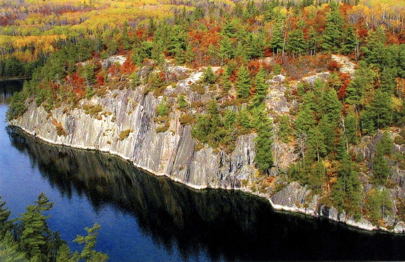
Voyageurs National Park
48.5000° N · 92.8833° W · National Park
Photo: Wikimedia Commons contributor · Public domain · Wikimedia Commons
Voyageurs National Park is a United States National Park near International Falls, Minnesota. Named for French-Canadian fur-trade canoe men called voyageurs. The free Lokali audio guide runs 7 minutes.
✓ Published October 2026 · how we write these guides
Visitor facts
| Lokali audio guide | 7 min · free |
|---|---|
| Type | National Park |
| Location | St. Louis County, United States |
| Coordinates | 48.5000, -92.8833 |
| Official website | nps.gov |
| Languages | 50+, in the Lokali app |
The story
Listen first. Water laps against pink and grey rock, smoothed by ice into gentle domes. A loon calls somewhere across the bay, a long wavering note that seems to hang over the lake. The air smells of pine resin, cold water, and wet stone. Welcome to Voyageurs National Park, in the far north of Minnesota, along the border with Canada. This is a park you do not simply drive through. Here, water is the main road.
That is the first surprise for many visitors. Most of this park cannot be reached by car at all. Four large lakes shape it: Rainy, Kabetogama, Namakan, and Sand Point. Between them lie hundreds of islands, narrow channels, and quiet bays. A large share of the park's area is water. To explore beyond the shoreline, people use canoes, kayaks, motorboats, and houseboats in summer. In winter, they travel on skis, snowshoes, and snowmobiles across the frozen surface.
The park takes its name from the voyageurs. They were French-Canadian canoe men who worked in the fur trade during the eighteenth and nineteenth centuries. They paddled large birchbark canoes loaded with trade goods and beaver pelts. They worked long days, often paddling from dawn to dusk. Stories say they sang to keep their strokes in rhythm. The waterways you see here formed part of a great trade route that ran across the continent. The international border still follows much of that old canoe path today.
Long before the voyageurs, this was Indigenous homeland. People have lived and travelled on these lakes for thousands of years. In more recent centuries, the Ojibwe people fished here, gathered wild rice in the shallow bays, and harvested berries and birch bark. Wild rice still grows in some quiet corners of the region. It is a tall water grass, and its grain remains an important food and a cultural tradition. The canoe itself, made of birch bark, came from Indigenous knowledge.
Now look down at the rock beneath your feet. This is part of the Canadian Shield, a vast area of very ancient bedrock. Some of the stone here is among the oldest exposed rock on Earth, billions of years old. Glaciers scraped across this land during the last Ice Age. They carried away soil, polished the surface, and gouged out the basins that became these lakes. You can sometimes see long scratches in the rock, left by stones dragged under the moving ice.
The forest grows right on top of this thin, rocky ground. You will see pine, spruce, birch, and aspen, with their roots gripping cracks in the stone. This is the southern edge of the great northern forest, known as the boreal forest, which stretches across Canada. In autumn, birch and aspen leaves turn bright yellow against the dark green of the conifers. In spring, the edges of the lakes slowly lose their ice. The whole landscape seems to wake up at once.
Wildlife lives close to the water here. Watch for bald eagles perched in tall pines along the shore. Common loons dive for fish and surface far from where they went down. Beavers build lodges of sticks and mud in sheltered bays, and their gnawed stumps line some shorelines. Gray wolves live in the park, though they are shy and rarely seen. Black bears, otters, and white-tailed deer also share these woods. Early morning and evening are the best times to watch quietly.
This region also had a brief taste of gold fever. In the 1890s, prospectors found gold near Rainy Lake. A small boomtown appeared, with miners, shops, and hopeful newcomers. The excitement did not last long. The gold proved difficult and costly to extract, and the town faded within a few years. Today, the remains of an old mine site sit on Little American Island. A short trail there leads past traces of that hopeful, short-lived rush.
One of the park's best-known places is Kettle Falls, far out on the water at the eastern end. A historic hotel stands there, built in the early twentieth century. It served loggers, fishermen, and travellers, and it has been restored. Locals like to point out an unusual quirk of geography here. Because of the way the border bends, you can stand in the United States and look south into Canada. You can reach this spot only by boat or floatplane.
Another quiet surprise waits on the north shore of Kabetogama Lake. These are the Ellsworth Rock Gardens. In the twentieth century, a man named Jack Ellsworth spent many summers stacking stones into terraces, flower beds, and abstract sculptures on a granite hillside. Some of his figures look like animals, others like simple shapes. The National Park Service has worked to restore the gardens. They feel strange and personal in the middle of the wilderness, a reminder of one person's patient work.
Voyageurs was established as a national park in the 1970s. It protects a landscape that once saw logging, commercial fishing, and summer cabins. Some old cabin sites and resorts remain, and parts of that human history are preserved. Visitor centres stand at Rainy Lake, Kabetogama Lake, and Ash River. They offer exhibits, maps, and advice from rangers. Many visitors start there, then join a ranger-guided boat tour or rent a boat to explore further.
When night falls, look up. Far from big cities, the sky over these lakes grows very dark. The park has been recognised as an International Dark Sky Park. On clear nights, you can see the Milky Way stretch across the sky. In this northern location, people sometimes see the northern lights, or aurora borealis. These are glowing curtains of green and sometimes pink light, caused by particles from the Sun striking the upper atmosphere. Their colours often reflect on the still water.
In winter, the park changes completely. The lakes freeze thick, and a marked ice road may open across part of the frozen surface when conditions are safe. People drive, ski, and snowshoe where boats travelled a few months earlier. Ice fishing shelters appear on the lakes. The silence becomes deep, broken only by the cracking and groaning of the ice as temperatures change. Locals describe this sound as eerie but beautiful, almost like the lake is breathing.
Before you leave, pause at the water's edge for a moment. Notice how the light moves across the surface. Notice the smooth rock, the tilted pines, the far line of islands. The voyageurs saw a very similar view from their canoes. As you walk away, listen once more for the loon. If it calls, you will hear the same sound that has carried across these lakes for thousands of years.
Key facts
What to look for
Practical tips
Common questions
Is there a free audio guide to Voyageurs National Park?
Yes — the Lokali app narrates Voyageurs National Park free of charge in 50+ languages. The guide runs about 7 minutes, covers the history, what to look for on site and practical tips, and works offline once downloaded.
Where is Voyageurs National Park?
Voyageurs National Park is near St. Louis County, United States, at 48.5000, -92.8833. Tap the map link on this page for directions from where you are.
What is Voyageurs National Park known for?
Named for French-Canadian fur-trade canoe men called voyageurs. Four large lakes: Rainy, Kabetogama, Namakan, Sand Point.
What should you look for at Voyageurs National Park?
Glacial scratches carved into smooth, rounded shoreline rock. Bald eagles perched high in shoreline pines. Beaver lodges built of sticks in sheltered bays.
What should you know before visiting Voyageurs National Park?
Start at a visitor centre for maps and ranger advice. Book a ranger-guided boat tour to reach remote sites.
When is the best time to visit Voyageurs National Park?
Pack insect repellent for summer evenings near the water.
On the map
Opens directions to Voyageurs National Park from your location.
Hear Voyageurs National Park in your language
The full story, narrated, in 50+ languages. Download it before you go and it plays offline, at your own pace, with no ticket and no tour group.