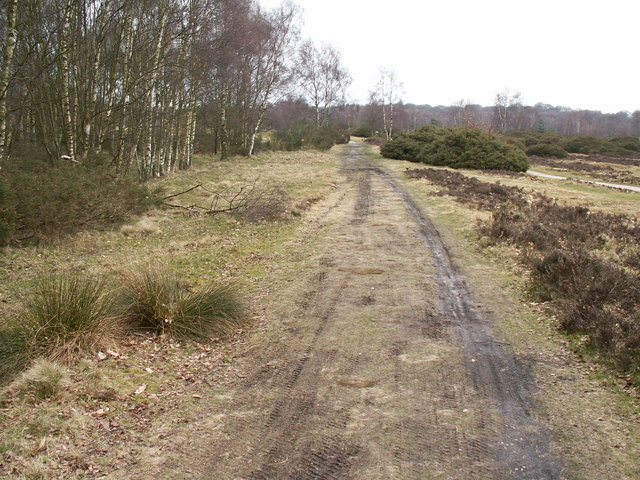
Icknield Street
52.5717° N · 1.8760° W · Archaeological Site
Photo: Phil Champion · CC BY-SA 2.0 · Wikimedia Commons
Icknield Street is a roman road that ran from Oxfordshire to Yorkshire. It is near Sutton Coldfield, United Kingdom. Local name for the Roman road known as Ryknild Street. The free Lokali audio guide runs 7 minutes.
✓ Published October 2026 · how we write these guides
Visitor facts
| Lokali audio guide | 7 min · free |
|---|---|
| Type | Archaeological Site |
| Location | Sutton Coldfield, United Kingdom |
| Coordinates | 52.5717, -1.8760 |
| Languages | 50+, in the Lokali app |
The story
Listen for a moment. Under the trees of Sutton Park the ground is soft with leaf litter and bracken. Then, under your boots, the line of the land changes. It rises into a long, low bank, firmer than the ground around it. It runs straight, far straighter than any path a deer or a dog walker would make. You are standing on a road that soldiers and traders used nearly two thousand years ago. It is grassed over now, and quiet, but it still holds its line.
This is Icknield Street, the local name for the Roman road that historians usually call Ryknild Street. It was one of the long military and trading routes the Romans laid across Britain after their invasion in the first century. The road ran roughly from the south west of England, near the Fosse Way in the Cotswolds, up through the Midlands and on towards Yorkshire. It linked forts, river crossings and settlements across a landscape the Romans were still working to control.
Here is the first surprise. The name is a kind of borrowed label. There is a much older route called the Icknield Way, an ancient track across southern England, and it has nothing to do with this road. In the medieval period, writers and mapmakers seem to have attached a similar name to this Roman line. So the road you are standing on carries a name that probably belongs to a different road entirely. Historians still discuss how the confusion began.
The second surprise is about survival. Across most of Britain, Roman roads were not lost. They were paved over. Modern traffic often runs along their lines, and the original surfaces lie buried under tarmac. Here in Sutton Park, a stretch of the road escaped that fate. Because this land stayed open heath and woodland for centuries, nobody built over the road. Stretches inside the park are often described as some of the best surviving examples of a Roman road anywhere in England.
Look at the shape of the ground ahead of you. The raised spine is called an agger, a Latin word for a built-up bank or embankment. Roman engineers dug material from the sides and piled it up to lift the road surface above wet ground. That way the rain ran off and the road stayed usable through the winter. On either side you may be able to trace shallow hollows. These are the remains of side ditches and pits where the builders dug their gravel and soil.
Take a few steps along the bank and notice how it behaves. It does not wander around obstacles in the way a country lane does. Roman surveyors worked in long straight sections, sighting from one high point to the next. When the land forced a change, they usually turned at an angle and then ran straight again. That habit is why so many Roman roads show up on modern maps as ruler-straight lines cutting across older, curving field boundaries.
It helps to picture who used this road. In its early years it served the army. Troops, supply carts and messengers moved between military posts. To the north, the road met Watling Street, another major Roman route, near the Roman settlement of Letocetum at Wall, close to Lichfield. To the south, it passed near the Roman fort at Metchley, in what is now Birmingham. Later, as the province settled, merchants, farmers and travellers would have used it too.
The surface you see today is not the surface those travellers saw. Centuries of falling leaves, grass and soil have softened every edge. The original road would have been a hard layer of packed gravel and stone, built up in layers over the bank. Imagine the sound of iron-rimmed wheels and hobnailed sandals on that gravel. Then compare it with what you can hear now, which is mostly birdsong, wind in the birches and perhaps a distant train.
The road survives because the park survived. Sutton Park has been common land for centuries. In the early sixteenth century, a royal charter from Henry the Eighth gave the park to the people of the town. That grant is usually credited to the efforts of Bishop John Vesey, a local man who rose high in the church. Because the land was held for common use, it was grazed and walked, but never ploughed flat or built over.
Today the park is a National Nature Reserve. It is one of the largest urban parks in Europe, with heathland, wetland, ancient woodland and a chain of pools. That matters for the road too. The same protection that keeps the heather and the wetlands also keeps this Roman bank intact. The road is a scheduled monument, which means it has legal protection as a site of national importance. Walking on it is fine, but digging or metal detecting is not.
The road also left a mark on the place names around here. The nearby district of Streetly, on the western edge of the park, is often said to take its name from this road. In Old English, the word street usually meant a paved Roman road, and the ending suggests a clearing or meadow. So the name may simply mean the clearing by the Roman street. Many English places with street in their names have a similar origin.
As you walk, keep in mind how little of the road is obvious at first glance. In summer, the bracken can grow tall enough to hide the bank. In winter, when the plants die back and the sun sits low, the long raised line becomes much easier to read. Low light throws shadows along the sides of the agger and makes the ditches stand out. Many visitors walk straight across the road without noticing it at all.
So, before you move on, stand still on the crest of the bank for a moment. Look along its line in one direction, then turn and look the other way. Feel the slight rise under your feet, and the gentle drop on each side. People walked this same line long before Sutton Coldfield existed as a town. As you leave, watch for the moment the ground flattens again. That small change in the land marks where the road ends and the park begins.
Key facts
What to look for
Practical tips
Common questions
Is there a free audio guide to Icknield Street?
Yes — the Lokali app narrates Icknield Street free of charge in 50+ languages. The guide runs about 7 minutes, covers the history, what to look for on site and practical tips, and works offline once downloaded.
Where is Icknield Street?
Icknield Street is near Sutton Coldfield, United Kingdom, at 52.5717, -1.8760. Tap the map link on this page for directions from where you are.
What is Icknield Street known for?
Local name for the Roman road known as Ryknild Street. Not connected to the prehistoric Icknield Way in southern England.
What should you look for at Icknield Street?
The raised grassy bank, or agger, running dead straight. Shallow hollows on each side marking old ditches. Pits beside the road where builders dug their gravel.
What should you know before visiting Icknield Street?
Visit in late autumn or winter when bracken dies back. Come early or late for low light along the bank.
When is the best time to visit Icknield Street?
Visit in late autumn or winter when bracken dies back.
On the map
Opens directions to Icknield Street from your location.
More to see near Icknield Street


Hear Icknield Street in your language
The full story, narrated, in 50+ languages. Download it before you go and it plays offline, at your own pace, with no ticket and no tour group.