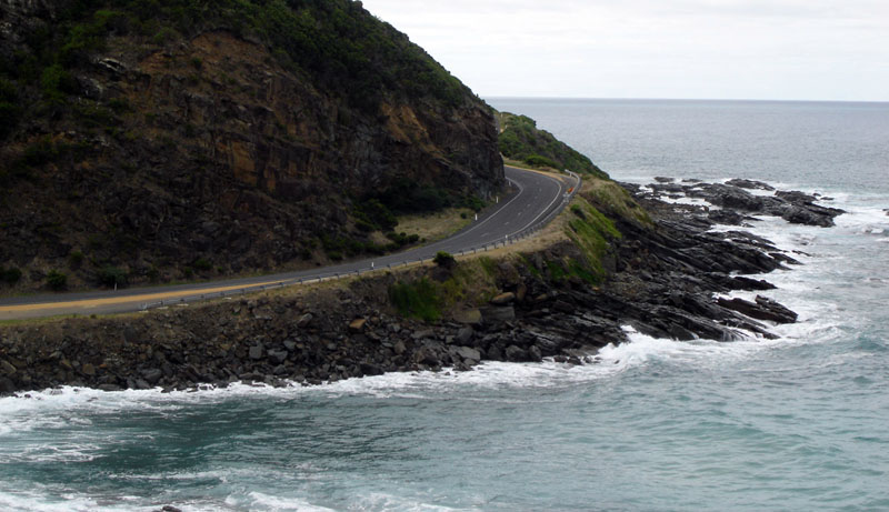
Great Ocean Road
38.7339° S · 143.6872° E · Tourist Attraction
Photo: User:Summi · CC BY-SA 3.0 · Wikimedia Commons
Great Ocean Road is a road in Victoria. Built by returned First World War soldiers as a memorial. The free Lokali audio guide runs 7 minutes.
✓ Published October 2026 · how we write these guides
Visitor facts
| Lokali audio guide | 7 min · free |
|---|---|
| Type | Tourist Attraction |
| Location | Victoria, Australia |
| Coordinates | -38.7339, 143.6872 |
| Official website | visitgreatoceanroad.org.au |
| Languages | 50+, in the Lokali app |
The story
Roll the window down. The first thing that reaches you is salt... then the sound. A low, steady roar from the Southern Ocean, breaking somewhere below the road. The tarmac curves hard to the left, and the cliff drops away beside you. There is no barrier of trees here, only air and water. On a clear day the sea shows three colours at once: pale green over sand, deep blue over rock, and white where the swell hits the shore.
This is the Great Ocean Road. It runs for roughly 240 kilometres along the southwest coast of Victoria, between Torquay and Allansford, near Warrnambool. On a map it looks like a simple coastal route. On the ground, it is something else. It climbs through rainforest, drops to surf beaches, and runs along limestone cliffs that the ocean is slowly cutting apart. And it has a story that most drivers never hear as they pass.
Here is the first surprise. This road is a war memorial. After the First World War, thousands of Australian soldiers came home to a country with few jobs for them. A plan took shape to put returned servicemen to work, building a road along this remote coast. The road was dedicated to the memory of those who did not come home. Many people describe it as the largest war memorial in the world. You are driving across it right now.
The work was brutal. Construction began in 1919, and the men worked with picks, shovels, wheelbarrows, and explosives. Machines were rare. They cut ledges into steep cliffs above the sea and cleared dense forest by hand. They lived in camps along the route, in heat, wind, and rain. Some men died during the work. The road was completed in 1932, after more than a decade of effort. Every curve you feel in the steering wheel was shaped by human hands.
If you come from the Torquay end, look for the Memorial Arch at Eastern View. It is a timber archway across the road, with a sculpture of two workers nearby. The arch has been rebuilt more than once over the years, after fire and after damage from vehicles. Many visitors stop here for a photograph. It is worth a few minutes. It marks the point where the story of this road becomes visible, and not just a line on a map.
Long before the soldiers arrived, this coast already had owners and names. The Wadawurrung people, the Eastern Maar people, and other Aboriginal groups have lived along these shores for thousands of years. Their knowledge of the land, the rivers, and the seasons runs much deeper than any road. As you travel, you may see signs and place names that carry their language. It is a quiet reminder that this landscape was home, and not wilderness, long before the first pick struck rock.
Near the start of the route sits Bells Beach, close to Torquay. For surfers, the name carries real weight. Long, powerful waves roll in here from the open ocean, and the beach hosts one of the oldest professional surfing contests in the world. Even if you never touch a board, stand at the lookout and watch. Count the seconds between the sets. Watch the surfers wait, paddle, and drop down the face of a wave. It is patient and dramatic at the same time.
Further west, the road bends inland into the Otways. The air changes. It turns cool and damp, and smells of wet earth and eucalyptus. Tall tree ferns crowd the gullies, and waterfalls drop through the forest. Around Kennett River, many travellers look up into the gum trees and find wild koalas. They are often asleep, curled into a fork of a branch. Look slowly. They are grey and still, and surprisingly hard to spot until suddenly you see one... and then another.
At the southern tip of the Otways stands the Cape Otway Lighthouse, one of the oldest surviving lighthouses on mainland Australia. It was built in the mid nineteenth century, when ships from Britain and Europe had to pass through a narrow, dangerous gap between this coast and King Island. Sailors called this stretch of sea the eye of the needle. For many of them, this light was the first sign of Australia after months at sea.
That danger gave the next section its name: the Shipwreck Coast. Fog, storms, hidden reefs, and strong currents wrecked many ships along these cliffs. The most famous wreck is the Loch Ard, which struck rocks near here in 1878. Out of everyone on board, only two people survived. One was a young crew member, Tom Pearce. The other was a young passenger, Eva Carmichael. Tom pulled Eva from the water into a narrow gorge. Today, that place is called Loch Ard Gorge.
And then come the Twelve Apostles, in Port Campbell National Park. These are tall limestone stacks, standing alone in the surf just off the cliffs. Here is the second surprise: there were never really twelve. The name was chosen partly for its sound. Fewer than a dozen stand today, and one stack collapsed in 2005. The ocean keeps working on them. Each stack began as part of the cliff, and the waves will one day bring each one down.
You can see that process nearby, at London Arch. This rock formation was once joined to the mainland by a double arch, and people called it London Bridge. In 1990, the arch closest to the shore suddenly collapsed. Two visitors were standing on the far section at the time. They were left stranded on a new island, and a helicopter had to lift them off. Nobody was hurt. But the story shows how quickly this coast can change its shape.
So take a moment where you are now. Listen to the sea against the rock. Feel the wind, which almost never stops here. Notice the layers in the cliff face, pale bands of stone laid down over vast stretches of time. This road joins two stories: soldiers who cut a path along the edge of the continent, and an ocean that is slowly taking that edge away. As you drive on, watch the next bend. The view is never quite the same twice.
Key facts
What to look for
Practical tips
Common questions
Is there a free audio guide to Great Ocean Road?
Yes — the Lokali app narrates Great Ocean Road free of charge in 50+ languages. The guide runs about 7 minutes, covers the history, what to look for on site and practical tips, and works offline once downloaded.
Where is Great Ocean Road?
Great Ocean Road is in Victoria, Australia, at -38.7339, 143.6872. Tap the map link on this page for directions from where you are.
What is Great Ocean Road known for?
Built by returned First World War soldiers as a memorial. Road runs roughly 240 kilometres from Torquay to Allansford.
What should you look for at Great Ocean Road?
Timber Memorial Arch with worker sculpture at Eastern View. Sleeping koalas in gum tree forks near Kennett River. Pale horizontal bands of limestone in the cliff faces.
What should you know before visiting Great Ocean Road?
Remember Australians drive on the left side of the road. Reach the Twelve Apostles at sunrise to avoid tour coaches.
When is the best time to visit Great Ocean Road?
Reach the Twelve Apostles at sunrise to avoid tour coaches.
On the map
Opens directions to Great Ocean Road from your location.
Hear Great Ocean Road in your language
The full story, narrated, in 50+ languages. Download it before you go and it plays offline, at your own pace, with no ticket and no tour group.