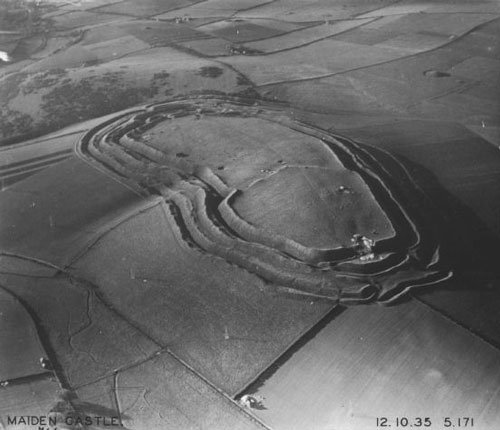
Maiden Castle
50.6950° N · 2.4700° W · Archaeological Site
Photo: Major George Allen (1891–1940) · Public domain · Wikimedia Commons
Maiden Castle is an Iron Age hill fort in Dorset, England, UK. Among the largest Iron Age hillforts in Europe. The free Lokali audio guide runs 7 minutes.
✓ Published October 2026 · how we write these guides
Visitor facts
| Lokali audio guide | 7 min · free |
|---|---|
| Type | Archaeological Site |
| Location | Weymouth, United Kingdom |
| Coordinates | 50.6950, -2.4700 |
| Official website | english-heritage.org.uk |
| Languages | 50+, in the Lokali app |
The story
Listen first. Wind moves across the grass, and somewhere below you a sheep calls out. The ground under your boots is soft turf over chalk, and it rises and falls in great green waves. Those waves are not natural. Every bank and every ditch around you was dug by human hands, with tools of antler, bone and iron. Welcome to Maiden Castle, on the high ground just outside Dorchester, a short drive inland from Weymouth.
This is one of the largest Iron Age hillforts in Britain, and among the largest in Europe. The area inside the ramparts is huge. People often compare it to around fifty football pitches. Walk the full circuit of the outer bank and you will understand the scale with your legs, not just your eyes. The banks climb steeply, and the ditches drop deep between them. Even today, after more than two thousand years of rain and grazing, they make a serious barrier.
But the story here starts long before the Iron Age. Around 3500 BCE, Neolithic farmers, the first farming communities in Britain, gathered on this hilltop. They dug a ring of interrupted ditches, a type of site archaeologists call a causewayed enclosure. Nobody lived inside it in the usual sense. It seems to have been a meeting place. People came for feasts, for trade, perhaps for ceremonies we can only guess at. So the first thing to know is this — the hill was important long before anyone thought of defending it.
Here is a detail most visitors miss. Later in the Neolithic, people built a long earthen mound across the hilltop. It is known as a bank barrow, and it stretched for more than five hundred metres. Its purpose is still debated. Part of it may have been linked to burial or ritual. Much of it has been worn down and is hard to trace now. Still, it means that even before the hillfort, this ground carried a monument longer than anything in the town below.
Then, for many centuries, the hill was quieter. The hillfort we see today began to take shape in the early Iron Age, roughly in the sixth century before Christ. At first it was a smaller enclosure on the eastern part of the hill. Over the following generations it was enlarged to cover the whole summit. The single rampart became several rings of banks and ditches. Each phase took enormous labour — thousands of baskets of chalk, carried and piled by hand.
Why build so much? Defence was part of it, but probably not all of it. Many archaeologists now think the ramparts were also a statement. They showed power, wealth and the strength of the community inside. From the valleys below, the white chalk banks would have shone in the sun when they were freshly cut. Imagine the hill not green, as it is now, but striped in bright white. People would have seen it from many kilometres away.
Inside, this was a busy settlement. Excavations found traces of round houses, storage pits for grain, and working areas. The people here belonged to a tribe known in Roman sources as the Durotriges, who held much of what is now Dorset. Now, a second surprise. Archaeologists found huge stores of sling stones here, tens of thousands of smooth pebbles. Many are thought to come from Chesil Beach, the long shingle bank near Weymouth. The coast you may have walked this morning supplied ammunition for this hill.
As you move around, look carefully at the eastern and western entrances. They are not simple gaps in the bank. The ramparts overlap and twist, creating winding passages. Anyone approaching the gate had to walk a long, exposed route under the eyes of defenders above. Try walking one of these entrances slowly. Notice how the banks rise around you and how little you can see ahead. The design still works on the nerves, even on a calm afternoon.
In the 1930s, the archaeologist Mortimer Wheeler and his wife Tessa Verney Wheeler led major excavations here. They worked with large teams of volunteers and made the site famous. Near the eastern entrance, they uncovered a group of burials. Some skeletons showed injuries from weapons. One had an iron bolt lodged in the spine, the kind fired by a Roman artillery machine. Wheeler told a dramatic story. He described a Roman legion storming the gates during the conquest of Britain in the first century.
It was a powerful story, and it spread widely. But later research has questioned it. When archaeologists looked again at the evidence, the burials seemed to span a longer period, not one bloody day. Some injuries may have come from different conflicts. The Romans certainly arrived in this region, and some violence is likely. But the single heroic last stand may be more Wheeler's storytelling than the full truth. It is a good reminder that archaeology is a conversation, not a final verdict.
After the Roman conquest, life on the hill faded. The population gradually moved to the new Roman town in the valley, called Durnovaria. That town is modern Dorchester, which you can see to the north. Yet the hill was not forgotten. Late in the Roman period, in the fourth century, a small temple was built on the summit. Its low stone foundations are still visible inside the ramparts. Look for them in the grass, a neat square outline among the soft curves of earth.
The place has also lived in literature. The novelist Thomas Hardy, who lived nearby, wrote about it under the name Mai-Dun, in a short story set on a stormy night among the earthworks. The origin of the name Maiden Castle is uncertain. One common theory links it to old words meaning a great hill. Another sees it as a name given by later people to an old, untaken fortress. Neither explanation is proven, so treat both as possibilities rather than facts.
Before you leave, stand on the highest rampart and turn slowly. To the north lies Dorchester. Southward, the land rolls toward the sea and Weymouth. The banks under your feet hold five thousand years of human effort — ritual, farming, building, fighting, and finally quiet. Listen again to the wind and the sheep. Notice the larks rising from the grass, and the chalk showing white where paths have worn through. Walk down slowly. The hill has been here longer than any story told about it.
Key facts
What to look for
Practical tips
Common questions
Is there a free audio guide to Maiden Castle?
Yes — the Lokali app narrates Maiden Castle free of charge in 50+ languages. The guide runs about 7 minutes, covers the history, what to look for on site and practical tips, and works offline once downloaded.
Where is Maiden Castle?
Maiden Castle is near Weymouth, United Kingdom, at 50.6950, -2.4700. Tap the map link on this page for directions from where you are.
What is Maiden Castle known for?
Among the largest Iron Age hillforts in Europe. First used as a Neolithic meeting place around 3500 BCE.
What should you look for at Maiden Castle?
Winding, overlapping banks at the western and eastern entrances. Square stone foundations of the Roman temple on the summit. White chalk showing through worn paths on the ramparts.
What should you know before visiting Maiden Castle?
Wear sturdy shoes; the ramparts are steep and slippery when wet. Allow at least an hour to walk the outer circuit.
On the map
Opens directions to Maiden Castle from your location.
More to see near Maiden Castle


Hear Maiden Castle in your language
The full story, narrated, in 50+ languages. Download it before you go and it plays offline, at your own pace, with no ticket and no tour group.