
Bab edh-Dhra
31.2539° N · 35.5342° E · Archaeological Site
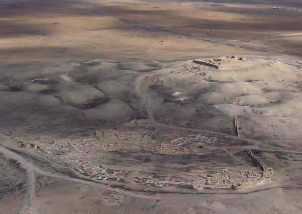
Photo: Ana al'ain · CC BY-SA 3.0 · Wikimedia Commons
Bab edh-Dhra is a human settlement. It is near Al-Karak, Jordan. Settlement and cemetery date to the Early Bronze Age. The free Lokali audio guide runs 8 minutes.
✓ Published October 2026 · how we write these guides
Visitor facts
| Lokali audio guide | 8 min · free |
|---|---|
| Type | Archaeological Site |
| Location | Al-Karak, Jordan |
| Coordinates | 31.2539, 35.5342 |
| Languages | 50+, in the Lokali app |
The story
Listen to the wind for a moment. It comes off the Dead Sea basin, dry and warm, and moves across a broad ridge of pale, crumbling earth. Underfoot, the ground is soft and powdery. Small fragments of pottery lie scattered in it, red and buff and grey. Around you, the hills of the Jordanian plateau rise in bare, folded layers of tan and rose. There are no columns here, no temple front, no grand gate. And yet this quiet ridge holds one of the largest ancient cemeteries ever found in the Near East.
You are standing at Bab edh-Dhra, on the southeastern side of the Dead Sea. The name is usually translated as "Gate of the Arm." The site sits where Wadi al-Karak, the valley that runs down from the town of Karak on the plateau above, opens onto the low plain. Below you, the Lisan peninsula reaches out into the sea like a tongue of land. People have used this spot for a very long time. Fresh water, a sheltered valley and a route between the highlands and the shore made it a natural place to settle.
The story here belongs to the Early Bronze Age. That is the period, roughly from the late fourth millennium to the late third millennium before Christ, when the first towns appeared across the southern Levant. The Levant is the old name for the lands along the eastern Mediterranean, including Jordan. This was centuries before the great kingdoms of the Bible. Writing had barely begun in Egypt and Mesopotamia. Here, the people who lived beside the Dead Sea left no texts at all. Everything we know comes from what they built and what they buried.
Archaeological work began seriously in the 1960s, when the American archaeologist Paul Lapp excavated the cemetery. From the 1970s, a long-running project led by Walter Rast and Thomas Schaub returned to the site and to the wider Dead Sea plain. Their teams studied the town, the tombs and nearby settlements over many seasons. Much of what you see around you today, the trenches and the exposed wall lines, comes from those decades of patient digging under a very hard sun.
Here is the first surprise. The cemetery is enormous. Researchers have estimated that it may contain many thousands of tombs, spread across the slopes around the town. Some estimates of the number of people buried here run into the hundreds of thousands, though those figures are debated. Either way, the dead far outnumber anyone who could have lived in the small town at one time. This was a burial ground used over many generations, and perhaps by people who lived well beyond these walls.
The earliest graves are shaft tombs. A burial party dug a vertical shaft down into the soft earth, then cut one or more small chambers off the bottom. In many of these chambers, archaeologists found bones that had been gathered and carefully arranged, often with skulls placed to one side. This suggests that people were buried elsewhere first, and their remains were brought here later. Pottery bowls, jars and other offerings lay beside them. Some of that pottery now sits in museum collections far from Jordan.
Later, the burial customs changed. People began to build charnel houses, which are above-ground mudbrick buildings used for many burials together. Some held the remains of large numbers of individuals, along with great quantities of pottery. A few of these structures were burned, and the fire preserved details that might otherwise have vanished. Walking the ridge, you are moving between these different traditions. Each one shows a community thinking carefully about family, memory and the dead.
Now turn toward the town itself. During the Early Bronze Age, the settlement here was enclosed by a substantial defensive wall of stone and mudbrick. Inside were houses, open spaces and, according to the excavators, buildings that may have had a religious purpose. The wall tells you something important. People here felt they needed protection, from neighbours, from raiders, or simply as a sign of status. A walled town in this harsh landscape was a serious investment of labour.
Think about how these people survived. The plain below the wadi could be farmed with water from the valley. Plant remains found at the site point to crops such as cereals and other food plants, and evidence suggests fruit trees were also grown. Animals grazed on the slopes. The Dead Sea itself offered salt and, in some periods, bitumen, a natural tar that people across the ancient world valued. This was not empty desert. It was a working landscape, managed with skill.
Near the end of the Early Bronze Age, the walled town was abandoned. The excavators found evidence of destruction, and the site was largely left empty for a long time afterwards. Similar changes happened across the region in this period, as many towns declined or disappeared. The causes are still discussed. Climate shifts, pressure on water and farmland, and conflict between communities have all been suggested. No single answer fully explains it.
Here is the second surprise, and it needs a careful note. Because Bab edh-Dhra lies near the Dead Sea and ended in destruction, some writers have linked it with Sodom, one of the cities of the plain in the Book of Genesis. A smaller site nearby called Numeira has sometimes been paired with Gomorrah. These ideas are popular, but they remain speculation. Many archaeologists point out that the dates and the evidence do not fit neatly. It is a story told about the site, not a proven fact.
What makes this place special is its honesty. There is no reconstruction, no dramatic restoration. What remains is low, eroded and easy to overlook. Look closely at the cut faces of the old trenches and you can see bands of darker and lighter soil. Each band marks a different moment of use, collapse or burning. In the afternoon, as the sun drops toward the Dead Sea, long shadows fall across the ridge and the wall lines become much easier to read.
Take your time as you walk. Stay on the clear paths, because the tomb shafts and old trenches can be unstable at the edges. Watch for the shine of broken pottery in the dust. Leave it where it lies. Every fragment belongs to the site and to the story that archaeologists are still piecing together. Notice, too, how quiet it is. Apart from the wind and the occasional passing truck on the Dead Sea road, there is very little sound.
Before you leave, stand still and look out toward the water. The pale shoreline, the flat peninsula and the steep hills behind you have changed very little in shape since the first shaft was dug here. Thousands of families once climbed this same slope carrying their dead and their offerings. Now the ridge is empty, warm and still. As you walk back to your car, look down once more at the dusty ground. Those small red fragments are the last voices of the town.
Key facts
What to look for
Practical tips
Common questions
Is there a free audio guide to Bab edh-Dhra?
Yes — the Lokali app narrates Bab edh-Dhra free of charge in 50+ languages. The guide runs about 8 minutes, covers the history, what to look for on site and practical tips, and works offline once downloaded.
Where is Bab edh-Dhra?
Bab edh-Dhra is near Al-Karak, Jordan, at 31.2539, 35.5342. Tap the map link on this page for directions from where you are.
What is Bab edh-Dhra known for?
Settlement and cemetery date to the Early Bronze Age. Paul Lapp excavated the cemetery in the 1960s.
What should you look for at Bab edh-Dhra?
Scattered red and buff pottery fragments in the dust. Exposed stone and mudbrick lines of the town wall. Dark burned layers visible in old trench walls.
What should you know before visiting Bab edh-Dhra?
Visit in early morning or late afternoon to avoid heat. Carry plenty of water; there are few facilities nearby.
When is the best time to visit Bab edh-Dhra?
Visit in early morning or late afternoon to avoid heat.
On the map
Opens directions to Bab edh-Dhra from your location.
More to see in Al-Karak


Hear Bab edh-Dhra in your language
The full story, narrated, in 50+ languages. Download it before you go and it plays offline, at your own pace, with no ticket and no tour group.