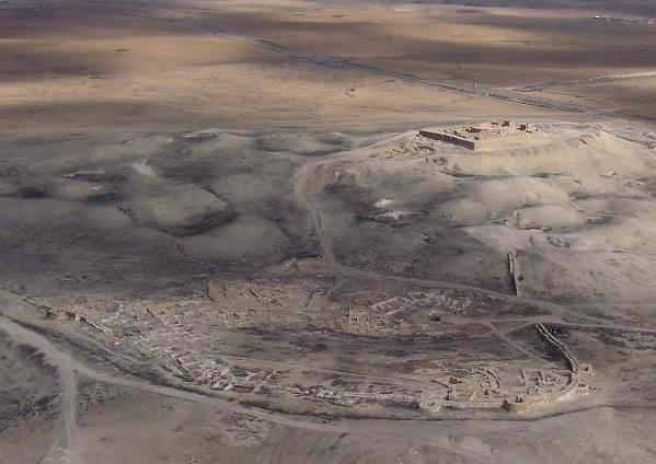
Photo: Wikimedia Commons contributor · Public domain · Wikimedia Commons
Tel Arad is an archaeological site west of the Dead Sea, Israel. Lower city dates to the Early Bronze Age. The free Lokali audio guide runs 7 minutes.
✓ Published October 2026 · how we write these guides
Visitor facts
| Lokali audio guide | 7 min · free |
|---|---|
| Type | Archaeological Site |
| Location | Arad, Israel |
| Coordinates | 31.2808, 35.1250 |
| Official website | parks.org.il |
| Languages | 50+, in the Lokali app |
The story
Listen for a moment. Out here, the loudest sound is often the wind moving across bare limestone. The ground underfoot is pale and dusty, scattered with small stones that crunch with every step. To the east, the land falls away toward the Judean Desert. On a clear day, the light here is hard and white, and it turns gold only near sunset. You are standing on one of the oldest planned towns in this part of the world.
Tel Arad sits in the northeastern Negev, a few kilometres west of the modern town of Arad. A tel is an artificial hill. It grows slowly, as people build new homes on the ruins of old ones, layer after layer, over centuries. This site actually holds two stories. Down below is a Canaanite city from the Early Bronze Age. Up on the hilltop is a later Israelite fortress. Between them lies a gap of well over a thousand years.
Start with the lower city, because it came first. Around five thousand years ago, in the early third millennium before the common era, people built a walled town here. Look at the long stone wall that curves around the slope. It was once punctuated by semicircular towers. Inside, archaeologists uncovered streets, houses, public buildings, and what appears to be a palace and temple area. For its time, this was a serious, organised settlement.
Now here is the first surprise. Water was the whole reason this city worked. This region gets very little rain. So the builders placed the town around a natural low point in the terrain. When winter rains came, runoff from the surrounding slopes flowed down into a large central reservoir. The town was shaped like a bowl, built to catch every drop. Stand near the lowest point and look up at the houses on the slopes. You can see the logic of the design.
The homes here have a style of their own. Archaeologists call it the Arad house. It is a broad, rectangular room, entered through a doorway on the long side. Often you step down slightly to enter. Low stone benches ran along the inside walls, where people could sit, sleep, or store goods. One of these houses has been reconstructed on site. Step inside it, if you can. Notice how cool and dim it feels compared with the open ground outside.
Then, for reasons that are still debated, the lower city was abandoned. Some scholars point to climate, others to changes in trade or politics. The truth is that we do not know for certain. What we do know is that the hill stood largely empty for a very long time. The houses collapsed. The wind and dust covered them. And that long silence is part of why the lower city survived so well for excavators to find.
Now turn your eyes to the top of the hill. That compact, square fortress belongs to the Iron Age, the time of the Kingdom of Judah. It guarded the southern edge of the kingdom and the desert routes that passed nearby. Over the following centuries, the fortress was destroyed and rebuilt several times. Later builders from the Persian, Hellenistic, and Roman periods also used this commanding spot. Each one added a layer to the hill.
Inside the fortress is the detail that makes Tel Arad famous among scholars. In one corner stands a small sanctuary. It has a courtyard, a hall, and a tiny raised niche at the back, often described as a holy of holies. In that niche stood a standing stone, called a massebah in Hebrew, a stone set upright as a symbol of the divine presence. On the steps in front were two small stone altars, believed to have been used for burning incense.
This is the second surprise. Many visitors assume worship in ancient Judah happened only in Jerusalem. Yet here, at a frontier fort, was a working shrine. Its plan echoes descriptions of the temple in the Hebrew Bible. Scholars still argue about when it was used and why it went out of use. Some link its end to religious reforms that centralised worship in Jerusalem. That theory is widely discussed, but it is not settled.
A quick note on what you are seeing. The original standing stone and altars were taken to the Israel Museum in Jerusalem for safekeeping. What stands here now are faithful replicas, placed where the originals were found. That means the setting is accurate, even if the stone itself is a copy. It is still worth pausing at the niche. Think about how small and intimate this space is, compared with the vast desert around it.
The fortress also gave historians something rare: written words. Excavators found many ostraca here. An ostracon is a piece of broken pottery used as a cheap writing surface, with ink letters on it. Many of these Hebrew notes are military and administrative. Several are addressed to a man named Eliashib, who seems to have managed supplies. They mention rations of wine, flour, and oil, and some refer to the Kittim, probably foreign mercenaries.
The main excavations took place in the 1960s and later. Ruth Amiran led the work on the Canaanite lower city, and Yohanan Aharoni led the work on the fortress. The site is now an Israeli national park, with paths connecting the two parts. The name Arad also appears in the Hebrew Bible, where a king of Arad fights the Israelites in the wilderness. How that story connects to these ruins is, again, a matter of scholarly debate.
Before you go, find a quiet spot on the fortress wall and look down at the lower city. From here, you can see both chapters at once. The broad, open ruins of the Canaanite town spread out below. The tight, defensive walls of the Judahite fort surround you. Five thousand years of people chose this same hill, for the same reasons: water, height, and a view of who was coming.
As you walk back, notice the stones again. Some were placed by hands in the Bronze Age. Others by soldiers who read letters about wine and flour. The wind still moves across the hill, the way it did for them. And the low bowl of the old reservoir still waits, as it always has, for the winter rain.
Key facts
What to look for
Practical tips
Common questions
Is there a free audio guide to Tel Arad?
Yes — the Lokali app narrates Tel Arad free of charge in 50+ languages. The guide runs about 7 minutes, covers the history, what to look for on site and practical tips, and works offline once downloaded.
Where is Tel Arad?
Tel Arad is in Arad, Israel, at 31.2808, 35.1250. Tap the map link on this page for directions from where you are.
What is Tel Arad known for?
Lower city dates to the Early Bronze Age. Upper fortress belongs to the Iron Age Kingdom of Judah.
What should you look for at Tel Arad?
Semicircular towers along the Canaanite city wall. The reconstructed Arad house with interior stone benches. The central low basin that once collected rainwater.
What should you know before visiting Tel Arad?
Visit early morning to avoid the strongest desert heat. Carry plenty of water and wear a sun hat.
When is the best time to visit Tel Arad?
Visit early morning to avoid the strongest desert heat.
On the map
Opens directions to Tel Arad from your location.
More to see near Tel Arad


Hear Tel Arad in your language
The full story, narrated, in 50+ languages. Download it before you go and it plays offline, at your own pace, with no ticket and no tour group.