
Tel Be'er Sheva
31.2447° N · 34.8408° E · Archaeological Site
Photo: gugganij · CC BY-SA 3.0 · Wikimedia Commons
Tel Be'er Sheva is an archaeological site in Israel. UNESCO listed the site in 2005 as a Biblical Tel. The free Lokali audio guide runs 7 minutes.
✓ Published October 2026 · how we write these guides
Visitor facts
| Lokali audio guide | 7 min · free |
|---|---|
| Type | Archaeological Site |
| Location | Beersheba, Israel |
| Coordinates | 31.2447, 34.8408 |
| Languages | 50+, in the Lokali app |
The story
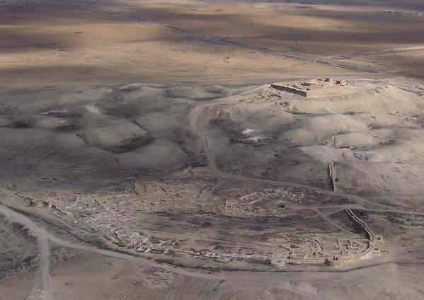
The ground here is pale and dry, and it crunches softly under your shoes. Out across the plain, the wind carries dust and the faint smell of warm stone. Below you, low walls of stone and mudbrick trace the outline of streets and rooms. This mound is Tel Be'er Sheva, the ancient heart of a city that modern Beersheba took its name from. Take a moment before the history. Just look at the shape of the hill, and notice how it rises gently above the flat land of the northern Negev.
First, a word about what a tel is. A tel is an artificial hill. It forms when people build a settlement, it is destroyed or abandoned, and later people build again on top of the ruins. Layer by layer, over centuries, the ground rises. So the mound under your feet is not natural rock. It is made largely of the remains of human life — walls, floors, ash, and broken pottery, stacked one generation upon another.
This tel sits a few kilometres east of the modern city centre, close to the Bedouin town of Tel Sheva. In 2005, UNESCO added it to the World Heritage List together with two other ancient mounds in Israel, Megiddo and Hazor. The three were listed as the Biblical Tels. They were chosen because they show how cities were planned and built in this land during the Iron Age, roughly three thousand years ago. Today the site is protected as a national park.
The name carries a story. In the Book of Genesis, Abraham digs a well here and makes an oath with a local king named Abimelech. The Hebrew word for well is be'er. Sheva can mean seven, or it can mean oath. So the name may mean the well of seven, recalling the seven lambs Abraham gave as a sign of the agreement. Or it may mean the well of the oath. The biblical text plays on both meanings at once.
Now, a gentle caution. The stories of Abraham belong to tradition and scripture. Archaeologists have not found evidence that ties the city you see to the patriarchs themselves. What the excavations do show is a carefully planned town from the Iron Age, the period of the kingdoms of Israel and Judah. Beersheba also appears in a well-known biblical phrase, from Dan to Beersheba. It marked the southern edge of the land, just as Dan marked the north.
Systematic excavation began here in 1969, led by the Israeli archaeologist Yohanan Aharoni. After his death, his colleague Ze'ev Herzog continued the work and published much of it. Their teams uncovered the town's plan in remarkable completeness. Many of the walls you see were rebuilt on their original stone foundations, using mudbrick much like the ancient builders used. That is why the streets feel so readable as you walk.
And here is the first surprise. For such a famous name, the ancient town was small. You can walk across it in only a few minutes. Yet it was planned with real care. A road ran in a ring just inside the city wall. Houses along the edge were built into the wall itself, so their back rooms helped form the defences. Other streets led inward from the ring. Few places let you see the full layout of an Iron Age town this clearly.
Walk toward the gate. The main entrance was designed to slow down anyone who arrived. Gates in this period often had chambers on each side, where guards could stand and where, according to biblical descriptions, elders sat to judge disputes and do business. Just outside the gate, the excavators found a large, deep well. It is tempting to connect it with Abraham, and some visitors do. But the well you see belongs to the life of the later city.
Near the gate stand long, narrow buildings divided by rows of pillars. These are usually interpreted as storehouses. Excavators found large numbers of clay storage jars inside them. Grain, oil, and wine may have been kept here, perhaps for the royal administration or for soldiers stationed in the town. Look at the stone pillars and imagine roofs above them, the rooms dim and cool, and pack animals waiting outside in the sun.
Now the second surprise. Inside the walls of one storehouse, the excavators found large dressed stones that did not belong there. When they put them together, they formed a horned altar — an altar with a raised stone horn at each of its four corners. Someone had taken the altar apart and reused its stones as building material. The original stones are now in the Israel Museum in Jerusalem, and the altar on this site is a replica.
Why was the altar dismantled? Scholars do not fully agree. One popular interpretation links it to a religious reform described in the Bible, when King Hezekiah of Judah is said to have removed local places of worship. Others read the evidence differently. It is a good example of how archaeology works. The stones are real and the facts of their reuse are clear. The reason behind it remains a question that experts still debate.
One more feature deserves your time — the water system. In a dry land, a town under siege could not survive without water. The builders cut a deep shaft into the rock with steps winding down, leading to underground cisterns. Rainwater and floodwater from the nearby riverbed could be channelled into them and stored. Going down feels like entering another climate. The air turns cooler, and sounds from above fade quickly.
After centuries of use, the town was destroyed. Many scholars link the destruction to the late eighth century before the common era, possibly during the Assyrian campaigns in Judah. Later peoples came and went, and the mound slowly fell quiet. Modern Beersheba grew up nearby, in the late Ottoman period, and later became the city you drove through to reach this place.
Before you leave, climb to a high point and turn slowly in a full circle. To one side lies the ring road you just walked. Beyond it, the plain stretches away, broken by the riverbed and the edges of the modern city. Listen to the wind moving across the stones. People have stood on this rise, looking across this same dry land, for thousands of years. Now it is your turn.
Key facts
What to look for
Practical tips
Common questions
Is there a free audio guide to Tel Be'er Sheva?
Yes — the Lokali app narrates Tel Be'er Sheva free of charge in 50+ languages. The guide runs about 7 minutes, covers the history, what to look for on site and practical tips, and works offline once downloaded.
Where is Tel Be'er Sheva?
Tel Be'er Sheva is near Beersheba, Israel, at 31.2447, 34.8408. Tap the map link on this page for directions from where you are.
What is Tel Be'er Sheva known for?
UNESCO listed the site in 2005 as a Biblical Tel. Shares World Heritage status with Megiddo and Hazor.
What should you look for at Tel Be'er Sheva?
The large well just outside the city gate. Rows of stone pillars inside the long storehouses. The replica horned altar with four corner horns.
What should you know before visiting Tel Be'er Sheva?
Visit early in the day to avoid the Negev heat. Carry plenty of water and wear a wide-brimmed hat.
When is the best time to visit Tel Be'er Sheva?
Visit early in the day to avoid the Negev heat.
On the map
Opens directions to Tel Be'er Sheva from your location.
More to see in Beersheba


Hear Tel Be'er Sheva in your language
The full story, narrated, in 50+ languages. Download it before you go and it plays offline, at your own pace, with no ticket and no tour group.