
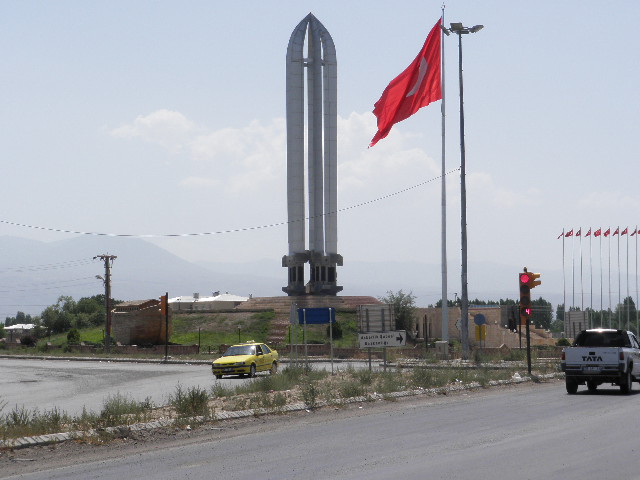
Photo: Hovo2004 · CC BY-SA 4.0 · Wikimedia Commons
Armavir is a historical capital. It is in Armavir, Armenia. The town was called Hoktemberyan during most of Soviet rule. The free Lokali audio guide runs 6 minutes.
✓ Published October 2026 · how we write these guides
Visitor facts
| Lokali audio guide | 6 min · free |
|---|---|
| Type | Archaeological Site |
| Location | Armavir, Armenia |
| Coordinates | 40.0819, 44.0333 |
| Languages | 50+, in the Lokali app |
The story
Feel the ground first. Out here on the Ararat plain, the earth is flat, dry and warm underfoot, and the air often carries dust from the surrounding fields. On a clear morning, look south. A great white mountain rises above the haze. That is Ararat, the mountain at the heart of Armenian identity. Today it stands across the border, in Turkey. Welcome to Armavir, a town whose name is far older than any street around you.
The modern town is young. It grew up in the twentieth century as a Soviet planned settlement, and for much of that time it carried a different name: Hoktemberyan, which means October, after the Russian Revolution of October 1917. After Armenia regained its independence in the early 1990s, the town took the name Armavir. That name was a deliberate choice. It reaches back more than two thousand years, to one of the oldest royal cities of the Armenian highlands.
This is the first surprise for many visitors. The ancient city of Armavir did not stand on these streets. Its remains lie a short distance away, on a low hill above the plain, near the village that also carries the name today. So the town you see now borrows its name from a place nearby. It is a bit like a family naming a new child after a great-grandparent.
The story of that hill begins with Urartu, an Iron Age kingdom that ruled these highlands before the Armenians appear clearly in written records. In the eighth century before Christ, an Urartian king named Argishti the First founded a fortified city in this area called Argishtikhinili. Its name means, simply, the city of Argishti. Urartian kings liked to record their building works in carved cuneiform, a script of wedge-shaped signs, and this region has yielded several such inscriptions.
Later, the site became known as Armavir. According to the medieval Armenian historian Movses Khorenatsi, it was the first capital of Armenia, founded by a legendary ancestor of the nation. That part is tradition rather than proven history. What historians do accept is that Armavir served as an important royal centre under the Orontid dynasty, an early line of Armenian kings, in the centuries after Alexander the Great.
Here is the second surprise. Archaeologists working at the old hill found inscriptions written in Greek. They date from the Hellenistic period, the era when Greek language and culture spread across much of the Near East after Alexander's conquests. Finding Greek texts on an Armenian hill shows how connected this plain once was. Merchants, envoys and ideas moved through here, between Persia, the Mediterranean and the Caucasus.
The glory did not last. Over time, Armenian kings moved their capital to other cities on the plain, and Armavir slowly faded into a quiet hill of ruins. Today, if you visit the site, you will mostly see low foundations, scattered stones and wide views. It takes some imagination. But stand on top, turn slowly in a circle, and you will understand why kings chose this place. The whole plain lies open below you.
Now come back to the modern town. Its layout follows the Soviet idea of order. Look for broad, straight streets, rows of trees for shade, and apartment blocks built of local stone in shades of pink, grey and honey. Armenia is famous for tuff, a light volcanic stone that is easy to carve. It gives many Armenian towns their warm colour, especially late in the afternoon.
Armavir is also a farming town at heart. The Ararat plain is one of the most fertile parts of the country, fed by rivers and irrigation channels. In summer, the markets fill with apricots, peaches, grapes, melons and tomatoes. The apricot is a proud symbol here. In fact, its Latin botanical name points to Armenia. If you pass a fruit stall, it is worth stopping. Vendors often offer a taste before you buy.
A short drive from the town stands one of the most important memorials in Armenia: Sardarapat. In May 1918, Armenian soldiers and volunteers fought a decisive battle here against the advancing Ottoman army. Many Armenians believe this victory saved the nation from destruction and opened the way to the first Armenian republic, declared that same month. The battle is remembered every year, and people still travel here to lay flowers.
The memorial complex was built in the late 1960s, for the fiftieth anniversary of the battle, and designed by the architect Rafael Israyelyan. It is built of red tuff. Look for the tall bell tower, the rows of winged bulls that guard the approach, and a long wall of eagles. Next to the memorial, a museum of Armenian ethnography displays carpets, tools, jewellery and everyday objects from village life. Allow time for it, because many visitors rush past.
Armavir Province holds even more. The holy city of Etchmiadzin, the centre of the Armenian Apostolic Church, lies within the same province. So this region links three great layers of Armenian memory. There is the ancient royal past on the hill, the faith of Etchmiadzin, and the modern struggle for survival at Sardarapat. Few small regions carry so many layers so close together.
Before you move on, pause for a moment. Listen to the traffic, the voices from a nearby courtyard, perhaps a rooster from a garden behind a wall. Look south again, if the haze allows. The mountain will still be there, pale and distant. Kings, farmers and soldiers have all looked at that same view from this plain... and now, for a few minutes, so do you.
Key facts
What to look for
Practical tips
Common questions
Is there a free audio guide to Armavir?
Yes — the Lokali app narrates Armavir free of charge in 50+ languages. The guide runs about 6 minutes, covers the history, what to look for on site and practical tips, and works offline once downloaded.
Where is Armavir?
Armavir is in Armavir, Armenia, at 40.0819, 44.0333. Tap the map link on this page for directions from where you are.
What is Armavir known for?
The town was called Hoktemberyan during most of Soviet rule. Urartian king Argishti the First founded a city here.
What should you look for at Armavir?
Pink and honey-coloured tuff stone on apartment facades. Mount Ararat rising white above the southern horizon. Winged bull statues guarding the Sardarapat memorial approach.
What should you know before visiting Armavir?
Come early on a clear morning for the best Ararat views. Bring water and a hat for the hot, open plain.
When is the best time to visit Armavir?
Visit the market in summer for apricots and melons.
On the map
Opens directions to Armavir from your location.
More to see near Armavir



Hear Armavir in your language
The full story, narrated, in 50+ languages. Download it before you go and it plays offline, at your own pace, with no ticket and no tour group.