
Wild Nephin National Park
54.0167° N · 9.7000° W · National Park
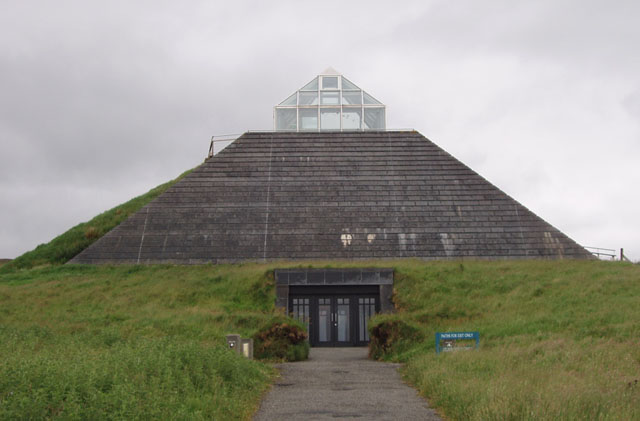
Photo: Youngbillyhappy · CC BY-SA 3.0 · Wikimedia Commons
Wild Nephin National Park is a national park in Ireland. The park was formerly called Ballycroy National Park. The free Lokali audio guide runs 7 minutes.
✓ Published October 2026 · how we write these guides
Visitor facts
| Lokali audio guide | 7 min · free |
|---|---|
| Type | National Park |
| Location | County Mayo, Ireland |
| Coordinates | 54.0167, -9.7000 |
| Official website | wildnephinnationalpark.ie |
| Languages | 50+, in the Lokali app |
The story
Listen for a moment. There is wind moving across open ground, and very little else. Underfoot, the earth gives slightly, soft and springy, like a mattress soaked in rain. The air smells of wet heather and peat. Welcome to Wild Nephin National Park, in the far west of County Mayo. Here the Atlantic weather meets one of the largest stretches of open bog and mountain left in Ireland.
For many years this place carried a different name. It was known as Ballycroy National Park, after the small village on its western edge, where the visitor centre stands today. The park was later renamed Wild Nephin. The new name better described the scale of the landscape. Today it covers a huge tract of bog, river valley and mountain, and it is one of the most remote national parks in the country.
The ground beneath your feet is the main character here. It is Atlantic blanket bog — a layer of peat that covers the land like a thick, wet blanket. It is a rare habitat. Blanket bog needs constant rain, cool summers and mild winters, so it only forms in a few places on Earth. The west of Ireland is one of them. The Owenduff bog, inside this park, is often described as one of the last intact active blanket bog systems in Western Europe.
Here is something most visitors miss. The bog is not dead ground — it is still growing. The key plant is sphagnum moss, a soft moss that holds many times its own weight in water. Because the bog is so wet, dead plants do not rot away completely. Instead they build up, very slowly, into peat. Scientists usually describe this growth as roughly a millimetre a year. A metre of peat, then, can hold many centuries of compressed plant life.
Look up from the bog and you will see the Nephin Beg mountains. They form a long, bare range, with rounded summits and steep, rocky sides. There are no roads across their heart. There are no villages there, and almost no buildings. On a grey day, the cloud often sits low on the ridges. The colours shift constantly — brown and gold in the heather, deep green in the grass, black where the peat is cut open by streams.
People did once cross this emptiness on foot. The Bangor Trail is an old route that runs through the mountains. It links the village of Bangor Erris, to the north, with the town of Newport, to the south. For generations, drovers used paths like this to walk cattle and sheep to market. Today the trail is a long and serious walk. In many places it is wet, rough and far from any help.
That sense of distance is deliberate. Part of this landscape was once managed as forestry, with planted conifers in neat rows. Over time, the aim changed. The idea was to let nature take back control — to reduce human management and allow a wilder land to return. You may still see some old plantation edges, but the long-term direction is toward wilderness. That idea of rewilding is part of why the name Wild Nephin was chosen.
Now for the second surprise. This park is one of the best places in Europe to see the night sky. Together with the surrounding area, it is recognised as a dark sky park, which means the night here has very little artificial light. On a clear, moonless night, the Milky Way stretches clearly from one horizon to the other. Many visitors from cities have never seen so many stars with their own eyes.
Wildlife here is quiet and easy to miss. In winter, flocks of Greenland white-fronted geese arrive from the far north to feed on the bogs. Golden plover and red grouse live among the heather. Otters hunt along the rivers, though they are shy and rarely seen. The Owenduff River runs through the park, and it is known for its wild salmon and sea trout. Watch the water for dark shapes beneath the surface.
If you want an easier taste of the park, start at the visitor centre in Ballycroy. From there, the Claggan Mountain Coastal Trail follows a raised boardwalk across the bog. It lets you walk over this delicate ground without damaging it. The path leads toward the shore, with views across the water toward Achill Island. On a clear day, the light over the sea can change in minutes, from silver to blue to dark slate.
The weather sets the rules here. Rain can arrive suddenly from the Atlantic, and fog can close in on the mountains with little warning. Away from the boardwalks, the ground is often soft, with hidden pools and channels. Phone signal can be weak or absent in the remote interior. For longer walks, local guidance is simple — tell someone your route, carry a map, and turn back if the cloud comes down.
The bog also matters far beyond this valley. Healthy peat holds huge amounts of carbon, locked away in the wet ground. When bogs are drained or cut, that carbon is released into the air. Across Ireland, peat was cut for fuel for centuries, and much of the country's bog has been damaged. Protected places like this one help keep carbon in the ground. They also give rare plants and birds space to survive.
As you walk, try to notice the small things. Tiny sundews grow in the wet moss — these are plants that catch insects with sticky red hairs. Bog cotton shows white tufts in early summer, moving in the wind. Pools of dark water reflect the sky perfectly on a still day. The colours are subtle, but the closer you look, the more variety you find.
Before you leave, stand still for one more minute. Feel the soft ground under your boots, and the wind on your face. Look out at the long brown slopes and the low mountains under a changing sky. This land has been forming slowly for thousands of years, mostly without us. As you walk back, listen again — for a bird call, running water, or simply the wind, crossing all that open space.
Key facts
What to look for
Practical tips
Common questions
Is there a free audio guide to Wild Nephin National Park?
Yes — the Lokali app narrates Wild Nephin National Park free of charge in 50+ languages. The guide runs about 7 minutes, covers the history, what to look for on site and practical tips, and works offline once downloaded.
Where is Wild Nephin National Park?
Wild Nephin National Park is near County Mayo, Ireland, at 54.0167, -9.7000. Tap the map link on this page for directions from where you are.
What is Wild Nephin National Park known for?
The park was formerly called Ballycroy National Park. Owenduff bog is a rare intact Atlantic blanket bog.
What should you look for at Wild Nephin National Park?
Red sticky sundews hiding in the wet moss. White tufts of bog cotton moving in the wind. Dark peat exposed where streams cut the ground.
What should you know before visiting Wild Nephin National Park?
Start at the Ballycroy visitor centre for an easy introduction. Bring waterproof boots and a full rain jacket.
On the map
Opens directions to Wild Nephin National Park from your location.
More to see near Wild Nephin National Park
Hear Wild Nephin National Park in your language
The full story, narrated, in 50+ languages. Download it before you go and it plays offline, at your own pace, with no ticket and no tour group.