Photo: Valacir · CC BY 2.0 · Wikimedia Commons
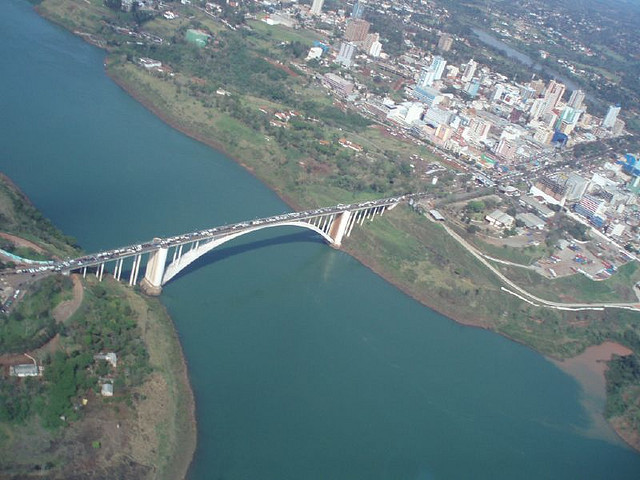
Friendship Bridge is a deck arch bridge between Brazil and Paraguay in South America. The bridge opened to traffic in 1965. The free Lokali audio guide runs 6 minutes.
✓ Published October 2026 · how we write these guides
Visitor facts
| Lokali audio guide | 6 min · free |
|---|---|
| Type | Bridge |
| Location | Foz do Iguaçu, Brazil |
| Coordinates | -25.5096, -54.6011 |
| Languages | 50+, in the Lokali app |
The story
Stand still for a moment and feel the concrete under your feet. It hums. Engines idle in long lines, motorbikes weave between them, and somewhere below, far below, a wide brown river moves without a sound. The air smells of exhaust, warm asphalt, and the damp green of the riverbanks. This is the Friendship Bridge, and it is never quiet.
In Portuguese it is called the Ponte da Amizade. On the Paraguayan side people say Puente de la Amistad. Both names mean the same thing. The bridge crosses the Paraná River and joins two countries. Behind you lies Foz do Iguaçu in Brazil. Ahead lies Ciudad del Este in Paraguay. In the middle of the span, the border runs through the air above the water.
Look down over the railing, if you can do so safely. The river here runs through a deep gorge, with steep walls of rock and thick forest. The Paraná is one of the great rivers of South America. It drains a huge part of the continent before it reaches the Atlantic far to the south. From this height the water looks calm. That calm is misleading. It is a powerful river, and its depth is the reason this bridge has the shape it does.
The bridge does not rest on piers standing in the water. Instead, it leaps the gorge on one great concrete arch. The arch springs from the rock on each bank and carries the roadway above it. For its time, this was an ambitious piece of engineering. Building supports in the middle of a deep, fast river would have been very difficult. An arch solved the problem by using the solid rock of the gorge itself.
The bridge opened in 1965, after years of planning and construction. It was a political project as much as an engineering one. Brazil and Paraguay were both looking for closer ties. For landlocked Paraguay, a road link to Brazil meant a route toward Brazilian ports on the Atlantic. That was important. A country without a coastline depends on its neighbours to reach the sea, and this bridge gave Paraguay a new door.
Here is a detail many visitors miss. The city on the far bank did not always carry its present name. It was founded in the late 1950s as Puerto Presidente Stroessner, named after Alfredo Stroessner, the military ruler of Paraguay at the time. After his government fell in 1989, the city was renamed Ciudad del Este, which simply means City of the East. The bridge, in other words, is older than the city's current name.
Now watch the people around you. Many of them carry large bags, boxes, and bundles wrapped in plastic. Ciudad del Este grew into one of the largest trading centres in South America. Lower taxes in Paraguay made electronics, perfume, clothing, and household goods cheaper than in Brazil. For decades, Brazilians have crossed this bridge to shop. Some come for one new phone. Others come to buy goods in bulk and resell them at home.
Those traders have their own name in Brazil. They are called sacoleiros, which comes from the Portuguese word for bag. You will see why. Some walk across with bags on both shoulders. Others ride on the back of motorbike taxis, holding their purchases in their laps. This daily movement of people and goods is the real life of the bridge. It is less a monument and more a working street that happens to cross a border.
That busy trade brings customs checks. On the Brazilian side, officials inspect vehicles and bags coming in from Paraguay. There are limits on how much shopping a person can bring back without paying duty. So the bridge is also a place of waiting, checking, and sometimes delay. Queues of cars and trucks can stretch a long way back into each city, especially at busy times of day.
Look upriver, and remember what lies beyond the bend. Not far from here, the Paraná is held back by the Itaipu Dam, one of the largest hydroelectric dams in the world. It is also a joint project of Brazil and Paraguay. And a short distance downriver, the Iguaçu River joins the Paraná. At that meeting point, three countries touch: Brazil, Paraguay, and Argentina. Locals call this region the Triple Frontier.
That makes this corner of the continent unusual. In one afternoon a person can stand in three countries, hear Portuguese, Spanish, and Guaraní, and pay in three currencies. Guaraní is an Indigenous language that is still widely spoken in Paraguay, alongside Spanish. You may hear it from vendors and drivers on the far side. The bridge is one of the threads that ties this mixed border world together.
The Friendship Bridge is not beautiful in the way a cathedral or a waterfall is beautiful. Its paint is often stained, its edges are crowded, and its traffic is loud. But it carries a story that is easy to see from here. Two countries chose to connect. Families, workers, and traders built their lives around that connection. Every bag that crosses in the afternoon heat is part of that story.
Before you move on, take one more look. Notice the curve of the arch below the road, the red earth on the banks, and the green wall of forest along the gorge. Listen to the engines, the horns, the voices in two or three languages. Then feel the river below, slow and silent, as it has run long before any bridge. When you walk away, the noise will follow you for a while. The river will not.
Key facts
What to look for
Practical tips
Common questions
Is there a free audio guide to Friendship Bridge?
Yes — the Lokali app narrates Friendship Bridge free of charge in 50+ languages. The guide runs about 6 minutes, covers the history, what to look for on site and practical tips, and works offline once downloaded.
Where is Friendship Bridge?
Friendship Bridge is near Foz do Iguaçu, Brazil, at -25.5096, -54.6011. Tap the map link on this page for directions from where you are.
What is Friendship Bridge known for?
The bridge opened to traffic in 1965. It links Foz do Iguaçu with Ciudad del Este.
What should you look for at Friendship Bridge?
The concrete arch curving beneath the roadway. Steep rock walls and forest lining the river gorge. Sacoleiros carrying large wrapped bundles across the span.
What should you know before visiting Friendship Bridge?
Carry your passport or national ID when crossing. Cross early in the day to avoid long traffic queues.
When is the best time to visit Friendship Bridge?
Cross early in the day to avoid long traffic queues.
On the map
Opens directions to Friendship Bridge from your location.
More to see near Friendship Bridge

Hear Friendship Bridge in your language
The full story, narrated, in 50+ languages. Download it before you go and it plays offline, at your own pace, with no ticket and no tour group.