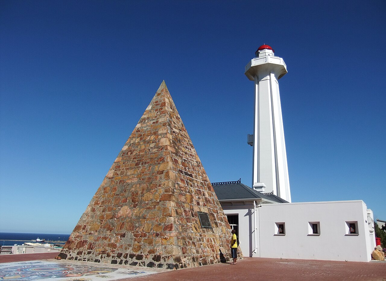
Donkin Reserve is a hilltop memorial park featuring the 52-metre Donkin Lighthouse and a pyramid monument erected in 1820 to commemorate the founding of Port Elizabeth. It is in Gqeberha, South Africa. Most visitors spend 45–60 min here. The free Lokali audio guide runs 5 minutes.
✓ Verified August 2026 · how we write these guides
Visitor facts
| Time needed | 45–60 min |
|---|---|
| Lokali audio guide | 5 min · free |
| Type | Monument |
| Best for | History |
| Location | Gqeberha, South Africa |
| Coordinates | -33.9583, 25.6009 |
| Languages | 45, in the Lokali app |
The story
The wind off the bay reaches you before anything else. It carries salt, and the high cry of gulls, and the low rumble of the harbor below. You are standing on an open hill above the city. The grass leans flat in the breeze. In front of you the land drops away toward the water. Above you stand two strange neighbors: a tall white lighthouse, and a pyramid built of stone. This is the Donkin Reserve.
The story of this place begins with grief. In 1820, a British soldier and official named Sir Rufane Donkin served as the acting governor of the Cape Colony. He was a man in mourning. His young wife, Elizabeth, had died far away in India after a short illness. She was only in her twenties. Donkin carried her memory with him across the ocean to this rough new coast.
He chose this hill for her. He ordered a stone pyramid built on its highest point. The pyramid rises about ten meters into the air. Each side of its square base runs about eight meters along the ground. There is no decoration on it. The stone is bare and gray. The shape is plain and serious, like the grief that raised it.
Walk close to the pyramid and look for the inscription. Donkin had words carved into it for his wife. He described her as one of the most perfect of human beings. And he did one more thing on this hill. He gave her name to the whole settlement below. He called it Port Elizabeth.
So her name spread out across the streets and the harbor and the bay. Every letter, every map, every ship record carried it. In 1938, more than a hundred years later, the pyramid was declared a national monument. It still stands exactly where he placed it, facing the sea.
Now turn a few steps to the lighthouse beside it. It was built in 1861. It rises about twenty-two meters from its base. Its walls are white and smooth. For generations, its light swung out over the dark water of the bay. Sailors watched for that beam as they steered toward the harbor at night.
The lighthouse no longer guides ships. Its old work is done. Today it holds the city tourism office on the ground floor. You can step inside, out of the wind. You can climb the stairs toward the top. From the upper windows, the whole sweep of the bay opens in front of you, gray and wide.
But the reserve is more than these two old monuments. In recent years, this hill became a place for public art and public memory. A walking path crosses the grass. Along it stand sculptures, cut-out figures, and panels of text. Together they tell the long story of the struggle for democracy in South Africa.
One sculpture rises higher than the rest. A tall metal figure stands with one arm lifted toward the sky. Close beside it, the national flag flies from a very tall flagpole, one of the tallest in the country. The cloth cracks and snaps in the wind. You can hear it from across the open ground, like a sail under strain.
Find a bench and sit for a while. Watch the city work below you. Cargo ships rest at anchor offshore, waiting their turn at the docks. Cars move along the streets in slow lines. The old houses of the central hill press close around the reserve, with their iron balconies and their steep, narrow roofs.
Think about how many meanings this small hill has held. It began as a private act of love and loss, raised by one grieving man. It became a practical tool, a light to bring sailors home. Then it grew into a public monument, a place where a nation remembers its hardest years. Few patches of grass carry so many layers at once.
Notice, too, how quiet it stays up here, even with the city so near. The wind covers the sound of the traffic. The long grass moves in waves. The pyramid lays a hard-edged shadow across the ground, and that shadow turns slowly as the sun crosses the sky.
Stand for one last moment between the pyramid and the sea. A man built this to hold the name of the woman he loved. Two centuries later, you are still speaking her name every time you say the name of this city. The people are long gone. The hill, the stone, and the name remain.
Key facts
What to look for
Practical tips
Common questions
How long do you need at Donkin Reserve?
Plan 45–60 min. That is the time most visitors spend at Donkin Reserve. The free Lokali audio guide adds about 5 minutes of narration you can listen to as you walk, so it fits inside your visit rather than adding to it.
Is there a free audio guide to Donkin Reserve?
Yes — the Lokali app narrates Donkin Reserve free of charge in 50+ languages. It covers the history, what to look for on site and practical tips, and it works offline once downloaded.
Where is Donkin Reserve?
Donkin Reserve is in Gqeberha, South Africa, at -33.9583, 25.6009. Tap the map link on this page for directions from where you are.
What should you know before visiting Donkin Reserve?
Visit late afternoon for soft light over the bay.
What is Donkin Reserve known for?
Stone pyramid built in 1820 by Sir Rufane Donkin.
What is the best time to visit Donkin Reserve?
Climb the lighthouse stairs for a 360-degree perspective of the coastline and industrial harbour.
On the map
Opens directions to Donkin Reserve from your location.
Reference
More to see in Gqeberha

Hear Donkin Reserve in your language
The full story, narrated, in 50+ languages. Download it before you go and it plays offline, at your own pace, with no ticket and no tour group.