Saklıkent National Park
36.4688° N · 29.4034° E · National Park
Photo: Cobija · CC0 · Wikimedia Commons
Saklıkent National Park is a national park in Turkey. It is in Kas, Türkiye. Saklıkent means "hidden city" in Turkish. The free Lokali audio guide runs 6 minutes.
✓ Published October 2026 · how we write these guides
Visitor facts
| Lokali audio guide | 6 min · free |
|---|---|
| Type | National Park |
| Location | Kas, Türkiye |
| Coordinates | 36.4688, 29.4034 |
| Official website | saklikent.tabiat.gov.tr |
| Languages | 50+, in the Lokali app |
The story
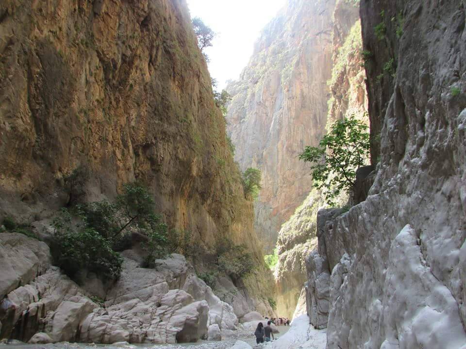
The first thing you notice is the cold. You step off the wooden walkway, the water closes around your ankles, and the chill arrives fast. It feels nothing like the warm Mediterranean air you left in the car park. Above you, two grey walls of rock rise so close together that the sky becomes a thin, bright ribbon. The river rushes over pebbles, and the sound bounces from wall to wall. Welcome to Saklıkent.
The name is Turkish, and it means "hidden city." Once you stand inside the gorge, the name makes sense. From the road, there is very little to see. A river leaves the mountains, a few restaurants sit beside it, and a dark gap opens in the hillside. Only when you walk inside does the full scale appear. The canyon feels like a secret the landscape has kept for itself.
A quick note on geography, because many visitors are surprised by it. Saklıkent is not in Kaş itself. It lies inland, in the hills of the Fethiye district, and most people come here from Kaş as a day trip. The drive takes you away from the coast and up into farmland. The air changes as you go. Sea salt gives way to dust, pine and the smell of the river. That contrast is part of the experience.
The gorge is often described as one of the longest and deepest in Turkey. It runs for about eighteen kilometres, and in places its walls climb roughly three hundred metres above the riverbed. Visitors can only walk a small part of it. The rest stays the territory of experienced canyoners with ropes and guides. In 1996, the area was protected as a national park. That protection helps keep these cliffs and this river in their wild state.
Now look at the walls themselves. This is limestone, a soft rock that water slowly dissolves and carves. Over an enormous span of time, the river cut down through the mountain, grain by grain. The result is smooth, curved stone, polished in some places and rough in others. Run your hand along a low section if you can reach it. You will feel ridges and hollows shaped entirely by moving water. No tool made these lines.
Here is the first surprise for most visitors. The water does not come only from rain. Much of it rises from springs at the base of the mountains, fed by snowmelt from the high ranges to the north. That is why it stays so cold, even in the middle of a hot summer. Many people walk in confidently and then gasp after a few steps. You are not imagining it. This water has travelled a long way underground before it reached your feet.
The walk usually begins on a wooden platform fixed to the rock face. It carries you safely above the fast water at the entrance. Then the platform ends, and the real gorge begins. You cross the stream, holding a rope or a helping hand, and continue on foot. The ground turns into a mix of gravel, smooth boulders and soft grey mud. Every few minutes the path shifts, and the river decides where you can go.
That grey mud brings the second surprise. Further inside, you will often see visitors with their arms, legs and faces covered in it. Locals and guides say the mud is good for the skin, and many people treat it as a free spa treatment. Whether it truly works is your own decision. But the sight of strangers laughing, painted grey from head to toe, is one of the warmest moments in the canyon.
As you walk deeper, pay attention to the light. Near the entrance, sunlight falls freely onto the water. Further in, the walls lean closer, and the light arrives indirectly, reflected off pale stone. Colours change from bright gold to cool blue and green. At midday, a narrow beam can drop straight down and land on the river like a spotlight. A few steps later, you are back in deep, quiet shade.
Listen, too. In the open sections, the river is loud and busy. In the narrow passages, the sound becomes deeper, almost like an echo inside a large hall. Voices carry strangely here. A child laughing far ahead may sound as if they stand right beside you. Pause for a moment, stay still, and let the noise of other visitors fade. Under it, you will hear only water and the occasional falling stone.
Back at the entrance, the human side of Saklıkent takes over. Restaurants have built wooden platforms directly above the river. Guests sit on cushions and low tables, with the cold stream running just underneath. Fresh trout is a common dish here, often from nearby farms. You will also see women rolling out thin dough for gözleme, a folded flatbread cooked on a wide metal griddle. The smell of butter and warm bread follows you to the car.
The area offers more than the walk. Downstream, operators run river tubing and rafting trips on calmer water. A short drive away lies Tlos, an ancient city of the Lycians, a people who lived along this coast long before the Romans arrived. Their rock-cut tombs look out over the same valley. Combining the gorge with Tlos gives you a single day of deep geology and deep human history together.
Before you leave, stand at the mouth of the gorge one more time. Look up at that thin line of sky between the walls. Feel the cool air flowing out of the canyon, even when the valley around you is hot. Notice the mud drying on your shoes, the sound of the water and the voices of families coming back out. The river will keep carving this rock long after today. For now, you have walked a small part of its long journey.
Key facts
What to look for
Practical tips
Common questions
Is there a free audio guide to Saklıkent National Park?
Yes — the Lokali app narrates Saklıkent National Park free of charge in 50+ languages. The guide runs about 6 minutes, covers the history, what to look for on site and practical tips, and works offline once downloaded.
Where is Saklıkent National Park?
Saklıkent National Park is in Kas, Türkiye, at 36.4688, 29.4034. Tap the map link on this page for directions from where you are.
What is Saklıkent National Park known for?
Saklıkent means "hidden city" in Turkish. The gorge runs for roughly eighteen kilometres.
What should you look for at Saklıkent National Park?
Smooth, water-carved curves in the limestone walls. Visitors painted head to toe in grey mud. Narrow ribbon of sky high between the walls.
What should you know before visiting Saklıkent National Park?
Wear water shoes with grip for slippery stones. Bring a waterproof bag for your phone.
When is the best time to visit Saklıkent National Park?
Visit in summer, when water levels are lowest.
On the map
Opens directions to Saklıkent National Park from your location.
More to see in Kas


Hear Saklıkent National Park in your language
The full story, narrated, in 50+ languages. Download it before you go and it plays offline, at your own pace, with no ticket and no tour group.