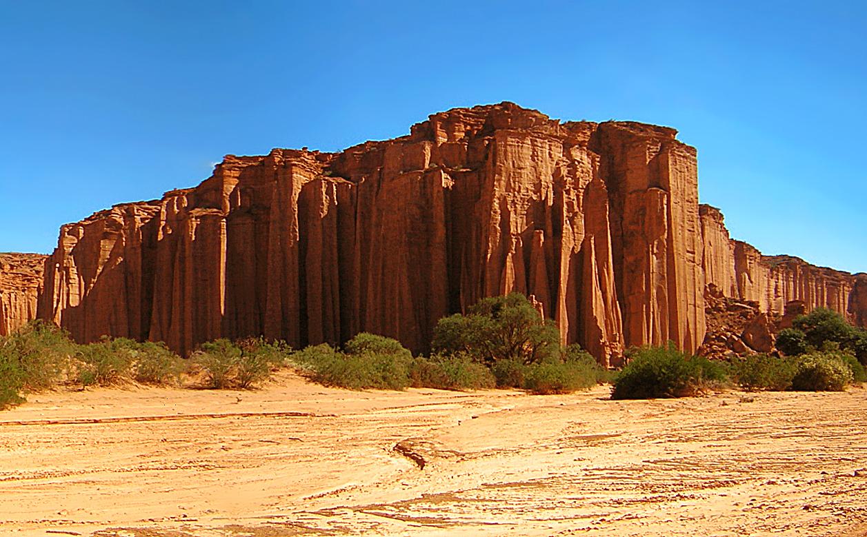
Talampaya National Park
29.7958° S · 67.8112° W · National Park
Photo: Gino Lucas T. · CC BY-SA 2.5 · Wikimedia Commons
Talampaya National Park is a national park of Argentina. Red sandstone cliffs formed in the Triassic period. The free Lokali audio guide runs 7 minutes.
✓ Published October 2026 · how we write these guides
Visitor facts
| Lokali audio guide | 7 min · free |
|---|---|
| Type | National Park |
| Location | La Rioja, Argentina |
| Coordinates | -29.7958, -67.8112 |
| Official website | parquesnacionales.gov.ar |
| Languages | 50+, in the Lokali app |
The story
Listen for a moment. Almost nothing moves here, except the wind. It slides along the canyon floor and carries fine red dust that settles on your shoes and your sleeves. Above you, the cliffs rise in sheer walls the colour of rust and brick. In the morning light they glow orange. By late afternoon they turn a deep, burnt red. This is Talampaya National Park, in the dry heart of La Rioja Province in northwestern Argentina... and it is one of the quietest places you may ever stand.
The first thing most visitors notice is scale. The canyon walls climb well over a hundred metres, and they are almost perfectly vertical in places. Your eye looks for something familiar to measure them against — a tree, a building — and finds nothing. The vehicles parked at the base look like toys. Even the sounds behave strangely. A voice carries further than you expect, then comes back to you from the rock.
That rock tells a very long story. The red sandstone around you formed during the Triassic period, more than two hundred million years ago. At that time this land looked nothing like a desert. Rivers, lakes and floodplains covered the region, and early reptiles moved through the vegetation. Layer by layer, sand and mud settled and hardened into stone. Then, over millions of years, the land lifted, and water and wind began cutting it open.
The canyon itself was carved by the Talampaya River. For most of the year, the riverbed is dry — a wide strip of sand and gravel between the cliffs. But when summer storms break over the surrounding mountains, water can rush through with real force. Those floods, together with the constant wind, keep shaping the walls. Look at the cliff faces and you will see long vertical grooves and smooth, rounded hollows. Each one is a record of water and wind working on soft stone.
Here is something many visitors miss. This region is one of the most important places on Earth for understanding the rise of the dinosaurs. The rock layers of Talampaya, and of Ischigualasto Provincial Park just across the border in San Juan Province, hold an unusually complete fossil record from the Triassic. Scientists have found early dinosaur relatives and other reptiles here. One small animal, Lagosuchus, carries the name of this place in its scientific name: Lagosuchus talampayensis.
Because of that fossil record, and because of the landscape itself, the two parks were added together to the UNESCO World Heritage List in 2000. Talampaya had already been protected for decades. It began as a provincial park in the 1970s and became a national park in the late 1990s. So the place you are standing in is protected both for its beauty and for what it can teach us about very early life on land.
People have also left their mark here, and much more recently. Near the entrance to the canyon, the dark surfaces of certain rocks carry petroglyphs — images cut into the stone by Indigenous people who lived and travelled through this region long before Europeans arrived. You can make out spirals, animal shapes, human figures and patterns whose meaning is still debated. Nearby, you may also see round hollows ground into flat rock. These are mortars, where people crushed seeds and pods, probably from the carob trees that still grow here.
The name Talampaya is itself something of a puzzle. It is often said to come from an Indigenous language of the Andes, and several translations circulate among guides and locals. You may hear different versions on different tours. The honest answer is that no single meaning is certain. What is certain is that this canyon was a known landmark for people crossing this dry country, long before it appeared on any modern map.
As you move deeper into the canyon, the walls begin to take on shapes. Erosion has left towers, spires and columns standing apart from the main cliffs. Guides have given many of them names. One tall rock is called The Monk, for its hooded outline. A group of pillars is known as The Three Wise Men. A wide section of fluted wall is called The Cathedral, because its vertical ridges look like the pipes of an organ or the columns of a great church.
One of the best-loved stops is a curved hollow in the cliff often called The Chimney. Stand inside it, call out, and your voice returns to you several times. Children love it. Adults usually try it too, after a little hesitation. It is a simple experience, but it makes the size of the walls feel personal. You are not only looking at the canyon — you are hearing its shape.
Life here is sparse, but it is not absent. Look along the canyon floor for low, tough shrubs and twisted carob trees, which survive on very little water. In one sheltered section, a small natural garden of native plants grows in the shade of the walls. Watch the ground and the slopes for guanacos, the wild relatives of the llama, and for the mara, a long-legged rodent that runs a little like a hare. And keep looking up. Andean condors sometimes ride the warm air above the cliffs.
A few practical words. Inside the canyon, visits run with authorised guides, usually by vehicle, on foot, or by bicycle, depending on the route. This protects both the fossils and the fragile rock. The climate is harsh. Days can be very hot, the sun reflects off the red stone, and the air is dry. Nights and early mornings can be surprisingly cold. Bring water, a hat, sun protection and a warm layer, even if the day begins bright and calm.
Before you leave, take one more slow look around. Notice how the light changes the colour of the walls even as you watch — red becoming orange, shadow becoming purple. Run your hand along the dust on a nearby rock, and remember that this stone was once the muddy edge of a river where early reptiles walked. As you head back toward the entrance, listen again for the wind. It is still at work here... shaping the canyon one grain of sand at a time.
Key facts
What to look for
Practical tips
Common questions
Is there a free audio guide to Talampaya National Park?
Yes — the Lokali app narrates Talampaya National Park free of charge in 50+ languages. The guide runs about 7 minutes, covers the history, what to look for on site and practical tips, and works offline once downloaded.
Where is Talampaya National Park?
Talampaya National Park is near La Rioja, Argentina, at -29.7958, -67.8112. Tap the map link on this page for directions from where you are.
What is Talampaya National Park known for?
Red sandstone cliffs formed in the Triassic period. Listed by UNESCO in 2000 alongside Ischigualasto.
What should you look for at Talampaya National Park?
Petroglyphs of spirals and animals near the canyon entrance. Round grinding mortars hollowed into flat rock surfaces. Organ-like fluted columns on the wall called The Cathedral.
What should you know before visiting Talampaya National Park?
Join an authorised guided tour to enter the canyon. Carry plenty of water and wear a wide-brimmed hat.
When is the best time to visit Talampaya National Park?
Visit in late afternoon for the deepest red tones.
On the map
Opens directions to Talampaya National Park from your location.
More to see near Talampaya National Park

Hear Talampaya National Park in your language
The full story, narrated, in 50+ languages. Download it before you go and it plays offline, at your own pace, with no ticket and no tour group.