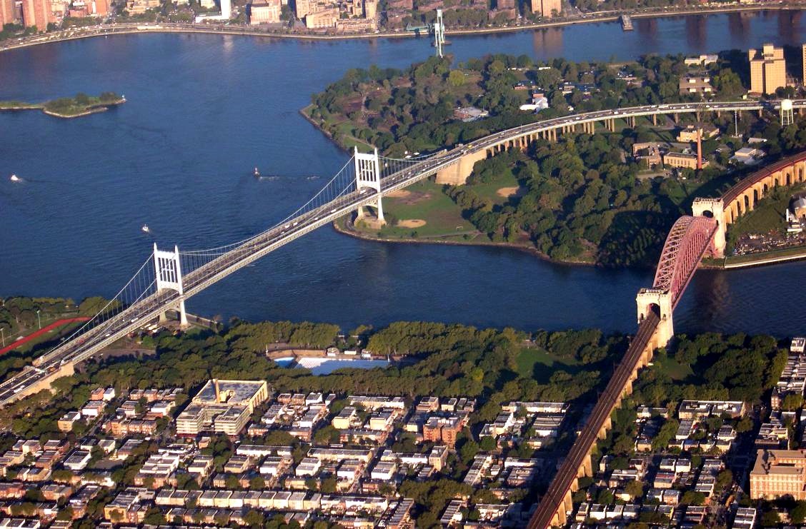
Robert F. Kennedy Bridge
40.7800° N · 73.9267° W · Bridge
Photo: Wikimedia Commons contributor · CC BY-SA 3.0 · Wikimedia Commons
Robert F. Kennedy Bridge is a bridge in New York City. Opened in 1936 after Depression-era construction delays. The free Lokali audio guide runs 7 minutes.
✓ Published October 2026 · how we write these guides
Visitor facts
| Lokali audio guide | 7 min · free |
|---|---|
| Type | Bridge |
| Location | New York, United States |
| Coordinates | 40.7800, -73.9267 |
| Official website | web.mta.info |
| Languages | 50+, in the Lokali app |
The story
Listen first. Beneath the steady roar of traffic there is a lower sound. Tyres hum across steel joints, and the deck gives a faint, rhythmic thump with every passing truck. Below, the water of the East River moves fast and grey, folding over itself in small whirlpools. The air smells of salt, exhaust and, on a warm day, cut grass from the island parks below. You are standing on one of the hardest-working pieces of infrastructure in New York City.
This is the Robert F. Kennedy Bridge. Most New Yorkers still call it by its older name, the Triborough Bridge. That name tells you exactly what it does. It ties together three of the city's five boroughs, Manhattan, Queens and the Bronx. It does this without a single landing in any of their busy neighbourhoods at its centre. Instead, the roads meet in the middle of the river, on an island most visitors have never heard of.
Here is the first surprise. The RFK Bridge is not really one bridge. It is a complex of three separate bridges, plus long viaducts, ramps and roads, all joined together. Each crossing uses a different kind of engineering, chosen for the water it spans. If you travel the whole system, you pass over a suspension bridge, a vertical lift bridge and a truss bridge. It is almost a short course in how bridges work.
The heart of the system is Randalls Island, which today includes the former Wards Island. Once these were two separate islands, divided by a narrow channel. That channel was later filled in, and the land became one. The three bridges radiate out from here like spokes. Below the ramps, the island holds sports fields, running tracks, waterfront paths and quiet stretches of marsh. It is a strange contrast — heavy traffic overhead, birdsong underneath.
The largest span is the suspension bridge to Queens. It crosses a stretch of water called Hell Gate. The name comes from early Dutch settlers, and it was well earned. Here, currents from Long Island Sound and the harbour collide in a narrow, rocky strait. For centuries the water wrecked ships. In the nineteenth century, engineers blasted away underwater rocks with huge explosions to make the passage safer. The current is still strong today.
Look along the river and you will see a second great structure nearby — a heavy steel arch. That is the Hell Gate Bridge, which carries trains, not cars. It is older than the RFK Bridge, and the two together form one of the most striking river views in the city. Photographers often frame them side by side. The arch is dense and solid. The suspension span is light, with its cables drawn in long, gentle curves.
The second crossing links the island to Manhattan, over the Harlem River. This one is a vertical lift bridge. Its whole roadway deck can rise straight up between tall steel towers, so that ships can pass underneath. Watch the towers and you can picture the machinery inside them. Today the deck is raised only rarely. Still, it was built to let river traffic move freely, which mattered greatly when the bridge was designed.
The third crossing reaches the Bronx over a narrow waterway called the Bronx Kill. Kill is an old Dutch word for a creek or channel. You still find it in place names all around New York. This span is a truss bridge, built from a rigid web of steel triangles. It is the smallest of the three, and easy to miss. But without it, the promise of three boroughs in a single name would not hold.
The story of the bridge is also a story about one man, Robert Moses. He was an unelected official who shaped the roads, parks and bridges of New York for decades. Construction on the bridge began around 1929, just as the Great Depression arrived. Work soon stalled for lack of money. Moses took control of the project, and federal funds from the New Deal helped bring it back to life. The bridge opened in 1936.
This is the second surprise. The tolls collected on this bridge did far more than pay for its own construction. Through a public authority, Moses used the steady flow of toll money to fund new projects across the city. That money gave him a source of power that did not depend on voters or the city budget. For many years his offices sat right here on the island, close to the toll plaza. The bridge was, in a real sense, his headquarters.
In 2008 the bridge was officially renamed for Robert F. Kennedy. He was a senator for New York and a former Attorney General of the United States. He was assassinated in 1968 while running for president. The new name honours his public life in the state he represented. Yet on traffic reports and in everyday talk, you will still hear Triborough. In New York, old names tend to stay.
Today the bridge carries a huge daily flow of cars, buses and trucks. Many are heading to or from the airports in Queens, or travelling between upstate New York and Long Island. The old toll booths are gone. Cameras and electronic readers now record each vehicle as it passes, so traffic keeps moving. If you are on foot or on a bicycle, parts of the system have walkways. They give you a view drivers never have the time to enjoy.
From up here, the city opens out in every direction. To the south, the towers of Midtown Manhattan rise in a long line. To the east lie the low rooftops of Astoria in Queens. To the north, you can see the Bronx and its rail yards. On a clear evening, the light turns the river copper, and the bridge cables catch the last of the sun.
Before you move on, take one more look at the steel around you. Notice the rivets, the layers of paint, and the bolts that hold everything together. Feel the small vibration under your feet as the traffic crosses. This structure has carried the city's daily life for nearly a century. As you walk away, listen again for that rhythmic thump of tyres on steel. It is the sound of three boroughs, still connected.
Key facts
What to look for
Practical tips
Common questions
Is there a free audio guide to Robert F. Kennedy Bridge?
Yes — the Lokali app narrates Robert F. Kennedy Bridge free of charge in 50+ languages. The guide runs about 7 minutes, covers the history, what to look for on site and practical tips, and works offline once downloaded.
Where is Robert F. Kennedy Bridge?
Robert F. Kennedy Bridge is in New York, United States, at 40.7800, -73.9267. Tap the map link on this page for directions from where you are.
What is Robert F. Kennedy Bridge known for?
Opened in 1936 after Depression-era construction delays. Links Manhattan, Queens and the Bronx via Randalls Island.
What should you look for at Robert F. Kennedy Bridge?
The steel arch of Hell Gate Bridge beside you. Whirlpools in the fast water of Hell Gate. Tall lift towers on the Harlem River span.
What should you know before visiting Robert F. Kennedy Bridge?
Use the walkways to see the river views on foot. Come near sunset for warm light on the cables.
When is the best time to visit Robert F. Kennedy Bridge?
Come near sunset for warm light on the cables.
On the map
Opens directions to Robert F. Kennedy Bridge from your location.
More to see in New York


Hear Robert F. Kennedy Bridge in your language
The full story, narrated, in 50+ languages. Download it before you go and it plays offline, at your own pace, with no ticket and no tour group.