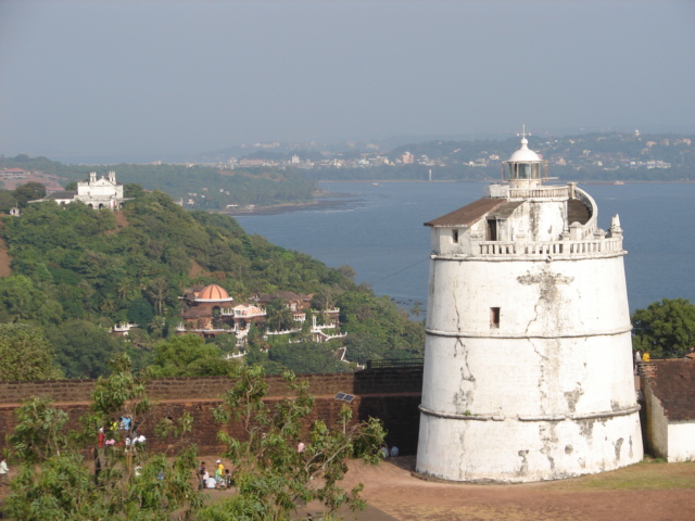
Photo: Drmarathe · CC BY-SA 3.0 · Wikimedia Commons
Fort Aguada is a seventeenth-century Portuguese fort in Goa. Portuguese completed the fort around 1612. The free Lokali audio guide runs 7 minutes.
✓ Published October 2026 · how we write these guides
Visitor facts
| Lokali audio guide | 7 min · free |
|---|---|
| Type | Fortification |
| Location | Panaji, India |
| Coordinates | 15.4923, 73.7737 |
| Languages | 50+, in the Lokali app |
The story
Start with the ground under your feet. It is rough, porous and rust-red, and it holds the heat of the sun long after noon. A steady wind comes off the Arabian Sea and carries salt and the faint smell of drying fish. Below the walls, waves break against black rocks. Crows call from the trees. Before any history, this is simply a high, open headland, with the whole coast of Goa spread out at its feet.
You are standing at Fort Aguada, on the Sinquerim headland, where the Mandovi River meets the sea. Panaji, the state capital, lies just across the river mouth to the south. The Portuguese built this fortress in the early seventeenth century and completed it around 1612. By then they had held Goa for about a century. Their capital, now called Old Goa, sat upriver. Every ship that wanted to reach it had to pass beneath these walls.
That was the point. In the early sixteen hundreds, Portugal no longer had these waters to itself. Dutch fleets were pushing into the Indian Ocean and attacking Portuguese ports and trade routes. On land, regional powers such as the Marathas, a rising Indian empire, were also a threat. A fort at the river mouth could watch for enemy sails, fire on hostile ships, and protect the trade that made Goa rich. This headland was the natural guard post for the whole estuary.
Now for the name. Aguada comes from the Portuguese word for water. This fort was a fortress, but it was also a watering station. A freshwater spring on the headland gave sailors something precious after weeks at sea — clean water to drink. Ships anchored nearby and refilled their barrels before long voyages to Lisbon or onward to other ports. Inside the upper fort, the Portuguese built a large cistern to store this water. It is one of the features visitors most often overlook.
Look closely at the stone itself. This is laterite, the red rock that underlies much of coastal Goa. When builders cut it from the ground, it is soft enough to shape. Once exposed to air, it hardens. That made it ideal for walls. You will see the same red blocks in old Goan houses, churches and garden walls. Here, the stone shows centuries of monsoon rain, with pitted surfaces and patches of dark moss in the cracks.
Notice also the shape of the walls. They are low, thick and often sloping, not tall and thin like a medieval castle. This design belongs to the age of cannon. Thick, angled walls could absorb or deflect cannon fire better than vertical towers. A dry moat once added another barrier around the upper fort. As you walk the ramparts, you can still see the openings where guns once pointed out to sea.
Now look up at the white tower. This is the old lighthouse, added in 1864, during the later years of Portuguese rule. It stands on the highest part of the fort and is often described as one of the oldest lighthouses of its kind in Asia. Its light guided ships safely into the river for over a century. It was retired in 1976, when a newer lighthouse was built nearby. The old tower now stands as a landmark in its own right.
Here is something many visitors miss. Fort Aguada is really two forts. The upper fort sits on the hilltop, with the lighthouse and cistern. The lower fort reaches down to the water, where it once protected a small landing for ships. In the twentieth century, part of the lower fort became a prison. Under Portuguese rule, it held people who campaigned for Goa's freedom. Today, the former Aguada Jail has been turned into a museum about that struggle.
Another surprise is a brief British chapter. Around the turn of the nineteenth century, during the wars against Napoleon, British troops were stationed in Goa. Britain and Portugal were allies, and the British feared a French attack on this coast. For a number of years, soldiers in red coats lived and drilled in the fort. Then they left, and Portuguese control continued until 1961, when Goa became part of India. The fort has seen several flags, but very little real fighting.
Like many old forts, Aguada has its share of stories. Locals say secret tunnels once ran from the fort to other points along the coast, perhaps for escape or for moving supplies unseen. These tales are popular, and guides sometimes repeat them. Treat them as legend rather than proven history. Still, standing here, it is easy to see why people imagine hidden passages beneath such heavy walls.
Now turn toward the view. To the north, the long sandy curve of Sinquerim and Candolim beaches stretches away, lined with palm trees and small fishing boats. To the south, across the river mouth, you can see the wooded Cabo headland, home to the residence of Goa's governor. On a clear day, the sea changes colour from green near the shore to deep blue further out. Watch for ships moving slowly into the river, following the same route sailors took centuries ago.
The fort is open to the sky, and the sun here is strong. There is little shade on the ramparts, so the cooler hours of morning or late afternoon are the most comfortable. Late in the day, the laterite glows a deeper red, and the light turns gold across the water. Many people come to watch the sun set over the sea. In the monsoon months, clouds roll in low and the whole headland turns intensely green.
Before you leave, stand still for a moment on the wall. Feel the rough stone under your hand, warm from the sun. Listen to the waves below, the same sound the soldiers and sailors heard here four centuries ago. Look out at the horizon where the fleets once appeared. As you walk back down, notice the red earth on your shoes. It is the same stone that built these walls, and it will travel with you a little way.
Key facts
What to look for
Practical tips
Common questions
Is there a free audio guide to Fort Aguada?
Yes — the Lokali app narrates Fort Aguada free of charge in 50+ languages. The guide runs about 7 minutes, covers the history, what to look for on site and practical tips, and works offline once downloaded.
Where is Fort Aguada?
Fort Aguada is near Panaji, India, at 15.4923, 73.7737. Tap the map link on this page for directions from where you are.
What is Fort Aguada known for?
Portuguese completed the fort around 1612. Aguada means water in Portuguese.
What should you look for at Fort Aguada?
Porous red laterite blocks with moss in the cracks. The white tower of the old lighthouse. Gun openings facing out toward the sea.
What should you know before visiting Fort Aguada?
Visit in early morning or late afternoon to avoid heat. Bring water, a hat and sunscreen for exposed ramparts.
When is the best time to visit Fort Aguada?
Stay for sunset over the Arabian Sea.
On the map
Opens directions to Fort Aguada from your location.
More to see near Fort Aguada


Hear Fort Aguada in your language
The full story, narrated, in 50+ languages. Download it before you go and it plays offline, at your own pace, with no ticket and no tour group.