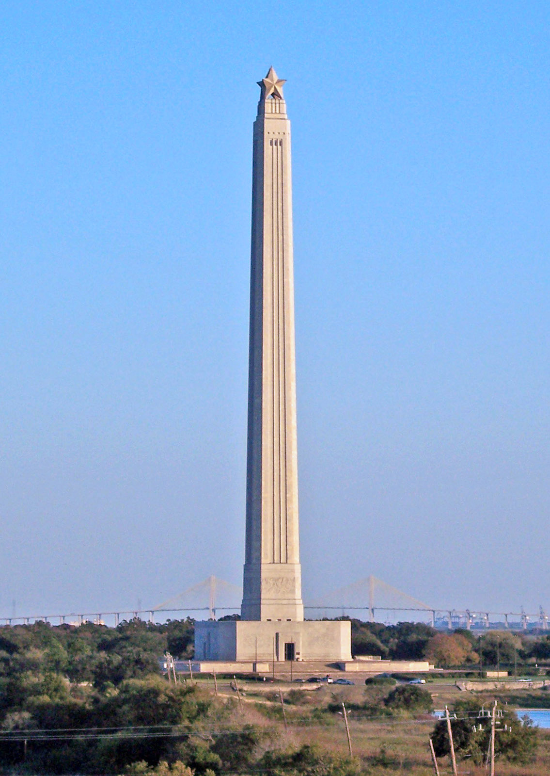
San Jacinto Monument
29.7489° N · 95.0803° W · Monument
Photo: Tijuana Brass at English Wikipedia · Public domain · Wikimedia Commons
San Jacinto Monument is a masonry column in Harris County, Texas, U.S. The Battle of San Jacinto was fought on April 21, 1836. The free Lokali audio guide runs 8 minutes.
✓ Published October 2026 · how we write these guides
Visitor facts
| Lokali audio guide | 8 min · free |
|---|---|
| Type | Monument |
| Location | Pasadena, United States |
| Coordinates | 29.7489, -95.0803 |
| Languages | 50+, in the Lokali app |
The story
Feel the wind first. It comes in off the water, warm and damp, carrying a faint smell of salt and marsh grass. The ground here is almost perfectly flat, so nothing blocks it. Then lift your eyes. A pale stone shaft rises out of that flat land, climbing higher and higher, until a great star sits against the sky. On a Texas coastal plain with no hills at all, this tower is the tallest thing for miles.
You are standing at the San Jacinto Battleground State Historic Site. It sits on the eastern edge of Pasadena, Texas, a short drive east of downtown Houston. This is not Pasadena in California. This is the Gulf Coast, where Buffalo Bayou meets the San Jacinto River. The meeting of those waters matters to the story. It is a big part of why two armies ended up facing each other on this ground.
To understand the monument, start in early 1836. Texas was then part of Mexico. Many settlers, together with some Tejanos, the Mexican-born Texans, had risen against the central government of President Antonio López de Santa Anna. That spring went very badly for the rebels. In March, the Alamo in San Antonio fell, and its defenders were killed. Soon after, hundreds of captured Texian soldiers were executed at Goliad. Fear spread across the region, and families fled east.
General Sam Houston commanded the small Texian army. For weeks he retreated, again and again, while Santa Anna's forces pursued him. Many of his own men were furious. They wanted to fight, and some openly questioned his courage. Houston kept moving. Historians still debate whether he followed a careful plan or simply waited for a chance. Either way, by mid-April both armies had come to this marshy corner of land between the bayou and the river.
On the afternoon of April 21, 1836, the chance came. The Mexican camp was resting, and many soldiers were not ready for an attack. The Texians advanced across the open ground. As they charged, they shouted a battle cry that Texans still know today — "Remember the Alamo! Remember Goliad!" Here is the surprising part. By most accounts, the main fighting lasted only about eighteen minutes. A war that had seemed lost was decided in less time than a coffee break.
Santa Anna escaped the field, but not for long. The next day, Texian scouts found him dressed in plain clothes, like an ordinary soldier. According to the usual account, he was recognized only when Mexican prisoners called out to him as their president. He was brought to the wounded Houston. Soon after, he signed agreements that ended the fighting. Texas became an independent republic. About a decade later it joined the United States, and that change helped set off a larger war that redrew the map of North America.
Almost exactly a century later, Texas prepared to celebrate the 100th anniversary of its independence. The monument was part of that celebration. Construction began in 1936 and was completed in 1939, in the middle of the Great Depression, with the help of public funding. The Houston architect Alfred C. Finn is credited with the design. For the workers who built it, this was steady work in very hard years. For the state, it was a statement in stone about how Texans saw their own origin story.
Now look at the height again. The monument rises just over 567 feet, roughly 173 metres. Here is a fact that surprises many visitors — it is taller than the Washington Monument in the American capital. Texans are proud of that detail, and it is often described as the tallest monumental column in the world. At the very top sits the Lone Star, the symbol of Texas. The star alone is several storeys tall and weighs many tons, though from the ground it looks almost delicate.
Next, walk up close to the stone and touch it. The core of the tower is reinforced concrete, but the outside is faced with a cream-coloured Texas limestone known as Cordova shellstone. Look carefully at the surface. In many blocks you can see small shapes pressed into the rock. These are fossil shells, the remains of sea creatures from an ancient ocean. So this monument to a short battle is wrapped in stone that took unimaginable ages to form.
Around the base, large carved panels tell the story of Texas in words cut into the stone. They begin with early exploration and settlement, then move through the growing conflict and the revolution itself. Take your time and walk the full circle. The language is formal, written in the confident style of the 1930s. Reading it, you learn about the battle, and also about how Texans of the Centennial years wanted that battle to be remembered.
Inside the base, you will find the San Jacinto Museum of History. It holds documents, objects, and artwork connected to Texas and the wider region across several centuries. An elevator also carries visitors up to an observation level near the top of the shaft. These experiences may need a separate ticket, so check at the entrance. If the weather is clear, the view from above is worth it. You can see the whole battleground spread out below, along with the river and the channel beyond.
That view brings a striking contrast. Just beyond the battlefield runs the Houston Ship Channel, one of the busiest industrial waterways in the United States. Refineries, storage tanks, and tall cranes line its banks. Large ships move slowly past. On one side, you have quiet marsh grass and a field where a nation was born in an afternoon. On the other side, you have the steel and smoke of modern Texas. Both belong to the same story of this coast.
Out on the grounds, markers show where the two armies camped and moved during the battle. Follow them if you have time. Listen as you walk. You may hear wading birds in the marsh, the hum of distant traffic, and perhaps a ship's horn from the channel. In spring, the air grows heavy and warm, much as it would have been on that April day in 1836. The land has changed, but the flatness and the wind are much the same.
Before you leave, stand once more at the foot of the monument and look straight up. Follow the line of the cream stone all the way to the star. Then turn and look out across the open field. Somewhere on that flat ground, in a few loud minutes, the future of this region shifted. As you walk back to your car, notice the wind again, still coming in off the water, still moving the grass.
Key facts
What to look for
Practical tips
Common questions
Is there a free audio guide to San Jacinto Monument?
Yes — the Lokali app narrates San Jacinto Monument free of charge in 50+ languages. The guide runs about 8 minutes, covers the history, what to look for on site and practical tips, and works offline once downloaded.
Where is San Jacinto Monument?
San Jacinto Monument is near Pasadena, United States, at 29.7489, -95.0803. Tap the map link on this page for directions from where you are.
What is San Jacinto Monument known for?
The Battle of San Jacinto was fought on April 21, 1836. The main fighting lasted roughly eighteen minutes by most accounts.
What should you look for at San Jacinto Monument?
Fossil shells pressed into the cream Cordova shellstone facing. The Lone Star crowning the very top of the shaft. Carved panels around the base telling the story of Texas.
What should you know before visiting San Jacinto Monument?
Come early on summer days to avoid the strongest heat. Check at the entrance whether the elevator needs a separate ticket.
When is the best time to visit San Jacinto Monument?
Come early on summer days to avoid the strongest heat.
On the map
Opens directions to San Jacinto Monument from your location.
More to see near San Jacinto Monument
Hear San Jacinto Monument in your language
The full story, narrated, in 50+ languages. Download it before you go and it plays offline, at your own pace, with no ticket and no tour group.