Georgetown Waterfront
38.9048° N · 77.0754° W · Neighborhood
Georgetown Waterfront is a neighborhood in Washington, United States. Historic riverfront district along the Potomac with 18th-century rowhouses, cobblestone streets, and waterside parks. Most visitors spend 1–2 hours here. The free Lokali audio guide runs 5 minutes.
✓ Verified August 2026 · how we write these guides
Visitor facts
| Time needed | 1–2 hours |
|---|---|
| Lokali audio guide | 5 min · free |
| Type | Neighborhood |
| Best for | Local life |
| Location | Washington, United States |
| Coordinates | 38.9048, -77.0754 |
| Languages | 45, in the Lokali app |
The story
Feel the river wind. Gulls wheel over the Potomac. Rowing shells cut the water like long knives, eight oars moving as one. Cyclists ring their bells along the path. Fountains splash behind you, and the smell of the tide mixes with coffee from the cafes. Georgetown's waterfront is the place where a working port learned to relax.
You are standing where Georgetown began. The town was founded in 1751 on the Maryland shore of the Potomac, decades before Washington itself existed. Ships anchored here to load tobacco from inland farms. Wagons rolled downhill carrying hogsheads, the great barrels of cured leaf. The port made the town wealthy, and Georgetown kept its own city government until 1871.
For two centuries this shoreline worked hard. Tobacco gave way to flour, coal, and stone. Mills, lime kilns, and warehouses crowded the bank, and barges from the canal unloaded coal beside the wharves. A power plant rose above the river. The waterfront was loud, smoky, and useful, and almost nobody came here for pleasure.
The twentieth century changed the river's job. Shipping moved to deeper ports. The factories and rail yards closed one by one. For years, much of this shore was simply parking lots and rubble, a blank space between the city and the water. Old photographs show cars parked where you now see lawns and elm trees.
Then Georgetown turned around to face its river again. In 1986, the Washington Harbour complex opened just east of here, with restaurants, terraces, and a large fountain circled by sculptures. Boats tie up beside the diners on summer evenings. In winter, the fountain becomes an ice rink, one of the largest outdoor rinks in the region.
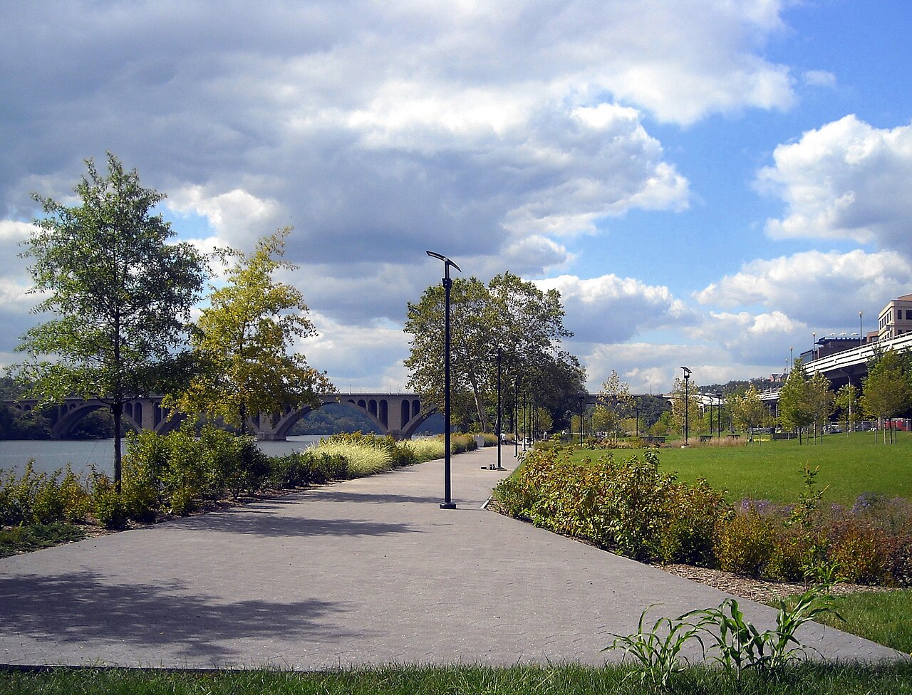
The green heart of the shoreline came later. Georgetown Waterfront Park opened in stages and was completed in 2011. It covers about ten acres between Key Bridge and the harbor, built where the parking lots used to be. It is a national park, run by the National Park Service. Neighbors campaigned for decades to turn this shore into parkland, and its lawns now slope gently to the water's edge.
The park rewards slow walking. Wide steps descend to the river like seats in a theater. A pergola frames the view. Near the foot of Wisconsin Avenue, a fountain sprays straight from the pavement, and children run through it on hot days. A stone labyrinth invites you to walk in circles on purpose. Benches face the water every few steps.
Look upstream at the arches of Key Bridge, finished in 1923. It is named for Francis Scott Key, the lawyer who wrote the words of the national anthem. His house once stood near the bridge's Georgetown end. At night, lamps trace the bridge's arches across the dark water. Beyond it, the river turns wild quickly, and herons hunt along the rocks.
Rowing is the waterfront's oldest surviving sport. Boathouses have lined this bank since the nineteenth century. University crews and club rowers train here in every season. If you come at dawn, you will hear the coxswains calling the rhythm across the water before you see the boats. Race days fill the river with color and shouting.
Look across the river. The wooded island in midstream is Theodore Roosevelt Island, a memorial forest for the conservation president. The towers behind it belong to Rosslyn, Virginia. Downstream, on a clear day, you can pick out the white roof of the Kennedy Center. Airliners climb the river corridor from the airport, following the water's curve.
The waterfront also connects walks in every direction. The Capital Crescent Trail begins near here and follows an old rail line upstream toward Maryland. Runners use it as a green highway out of the city. One block inland, the old C and O Canal runs parallel to the shore, so you can loop between river and canal in minutes.
Watch one rowing shell pass, from first sight to last. The oars swing, the boat glides, the wake fades. Ships full of tobacco once anchored in that same channel, and kayakers now chase the sunset where the barges tied up. The port is gone, but the river still sets the pace here. Sit on the river steps for a moment before you go, and let it set yours too.
Key facts
What to look for
Practical tips
Common questions
How long do you need at Georgetown Waterfront?
Plan 1–2 hours. That is the time most visitors spend at Georgetown Waterfront. The free Lokali audio guide adds about 5 minutes of narration you can listen to as you walk, so it fits inside your visit rather than adding to it.
Is there a free audio guide to Georgetown Waterfront?
Yes — the Lokali app narrates Georgetown Waterfront free of charge in 50+ languages. It covers the history, what to look for on site and practical tips, and it works offline once downloaded.
Where is Georgetown Waterfront?
Georgetown Waterfront is in Washington, United States, at 38.9048, -77.0754. Tap the map link on this page for directions from where you are.
What should you know before visiting Georgetown Waterfront?
Come at dawn to watch rowing crews train.
What is Georgetown Waterfront known for?
Georgetown founded in 1751 as a tobacco port.
What is the best time to visit Georgetown Waterfront?
Walk the C&O Canal towpath at dawn before crowds arrive.
On the map
Opens directions to Georgetown Waterfront from your location.
Reference
More to see in Washington



Hear Georgetown Waterfront in your language
The full story, narrated, in 50+ languages. Download it before you go and it plays offline, at your own pace, with no ticket and no tour group.