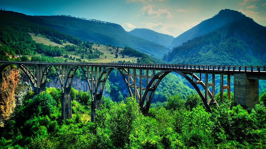
Đurđevića Tara Bridge
43.1504° N · 19.2952° E · Bridge
Photo: Daniel Borsos · CC BY-SA 3.0 · Wikimedia Commons
Đurđevića Tara Bridge is a bridge in close to Žabljak, Montenegro. Reinforced concrete bridge carried on five arches. The free Lokali audio guide runs 7 minutes.
✓ Published October 2026 · how we write these guides
Visitor facts
| Lokali audio guide | 7 min · free |
|---|---|
| Type | Bridge |
| Location | Žabljak, Montenegro |
| Coordinates | 43.1504, 19.2952 |
| Languages | 50+, in the Lokali app |
The story
Stand still for a moment and listen. Far below your feet, the Tara River runs over stone, and the sound comes up to you thin and distant, like wind in a narrow street. The concrete rail is cool under your palm. Pine and limestone scent the air. Look over the edge, carefully, and the drop keeps going. Green water, white rock, and then the dark shapes of trees clinging to the canyon walls. This is Đurđevića Tara Bridge, and the ground falls away beneath it.
You are in the far north of Montenegro, on the road between Žabljak and Pljevlja. Žabljak sits up on the Durmitor plateau, a mountain town of wooden roofs and cold mornings. The road from there winds down through forest until the land splits open. That split is the Tara Canyon. It is often described as the deepest river canyon in Europe, with walls that reach well over a kilometre in places. The bridge crosses it at one of the few points where a road could be carried over.
Now look at the shape of the bridge itself. It is not a suspension bridge, and it is not steel. It is made of reinforced concrete, carried on a series of five arches. The largest arch sits in the middle and spans more than one hundred metres. The smaller arches step down on either side, toward the canyon walls. From the road deck, the whole structure stretches for roughly 365 metres, and the river lies around 170 metres below.
The bridge was built in the late 1930s and finished in 1940. The design is credited to the engineer Mijat Trojanović, and the construction work was led by Isaac Russo. When it opened, it was one of the largest concrete arch bridges for road traffic anywhere in Europe. For the villages on either side of the canyon, the change was enormous. A crossing that once meant a long, steep journey down and back up could now be made in a few minutes.
Here is the first thing most visitors do not know. Only two years after it opened, part of this bridge was deliberately destroyed. During the Second World War, Italian forces occupied this region, and Yugoslav Partisan fighters were trying to slow their advance. In 1942, the Partisans blew up one of the bridge's arches. The road was cut, and the canyon became a barrier again. The bridge had been built to connect people, and in wartime it was broken to keep them apart.
The most painful part of the story belongs to one man. Lazar Jauković was an engineer who had worked on building this bridge. He knew exactly where its weak points were. He helped the Partisans plan the demolition, choosing how to bring down an arch he had helped to raise. Later in 1942, he was captured and executed, and his death took place here, at the bridge. Today a memorial to him stands near the crossing. Look for it as you walk.
After the war, the damaged arch was rebuilt, and the bridge reopened to traffic in 1946. If you look closely at the structure, you are looking at both moments together. Most of it is the original work of the late 1930s. One part is the postwar repair. To most eyes, the joins are hard to find. That is part of the achievement. The rebuilt section was made to match the original design, so the five arches still read as one continuous line.
Walk to the middle of the deck and look down the canyon, then up it. Notice how the arches are not decoration. Each one pushes its load outward and down, into the solid rock of the canyon walls. Concrete is very strong when it is squeezed, and an arch keeps it squeezed. That is why engineers chose this form here. The rock walls act like two great hands holding the bridge in place. The design is old in principle, but the scale was new.
The colour of the river below changes with the light and the season. On clear days it can look bright green or almost blue. After rain, it turns cloudier. The Tara is known across the Balkans for rafting, and in warmer months you may see small boats far below, bright dots moving with the current. The whole canyon lies within Durmitor National Park, which is listed by UNESCO as a World Heritage Site for its mountains, lakes, forests, and rivers.
Here is a second surprise. The quiet here is never complete. Every few minutes, you may hear a long, rising whir, and then a shout. That is the zipline. Several lines run across the canyon beside the bridge, and visitors fly over the river on a cable, hanging in a harness. From the bridge you can watch them leave one side and cross the gorge in under a minute. It gives you a sense of scale that photographs never quite manage.
Around the ends of the bridge, the scene is simple and practical. There are small cafés, places to park, souvenir stalls, and wooden huts where rafting and zipline trips are arranged. Families stop for coffee and grilled meat. Drivers pull over just long enough to take a picture. This is a working road, not only a viewpoint, so cars and trucks continue to cross. Keep to the footpath and watch for traffic when you stop to look over the rail.
For the best view of the whole structure, move away from the deck. A short walk along the road on either side gives you an angle where all five arches appear together, curving across the canyon. Early morning light falls softly on the concrete, and mist sometimes rises from the river. In the late afternoon, the canyon walls turn warm and golden, and the shadows of the arches stretch across the rock. Both times are quieter than the middle of the day.
Before you leave, come back to the rail one more time. Rest your hand on the concrete and feel how solid it is. Below you, the Tara is still cutting into the rock, as it has for a very long time. Above you, the arches still carry their load into the canyon walls. Somewhere nearby, the memorial to Lazar Jauković stands in the quiet. As you walk away, listen once more for the river, faint and steady, far below.
Key facts
What to look for
Practical tips
Common questions
Is there a free audio guide to Đurđevića Tara Bridge?
Yes — the Lokali app narrates Đurđevića Tara Bridge free of charge in 50+ languages. The guide runs about 7 minutes, covers the history, what to look for on site and practical tips, and works offline once downloaded.
Where is Đurđevića Tara Bridge?
Đurđevića Tara Bridge is in Žabljak, Montenegro, at 43.1504, 19.2952. Tap the map link on this page for directions from where you are.
What is Đurđevića Tara Bridge known for?
Reinforced concrete bridge carried on five arches. Completed in 1940 after construction in the late 1930s.
What should you look for at Đurđevića Tara Bridge?
The memorial to engineer Lazar Jauković near the crossing. Ziplines running across the canyon beside the bridge. Rafting boats moving on the green river far below.
What should you know before visiting Đurđevića Tara Bridge?
Walk along the road for a view of all five arches. Come early morning for soft light and fewer crowds.
When is the best time to visit Đurđevića Tara Bridge?
Come early morning for soft light and fewer crowds.
On the map
Opens directions to Đurđevića Tara Bridge from your location.
More to see near Đurđevića Tara Bridge

Hear Đurđevića Tara Bridge in your language
The full story, narrated, in 50+ languages. Download it before you go and it plays offline, at your own pace, with no ticket and no tour group.