Zoara is a biblical location. It is near Al-Karak, Jordan. Biblical Zoar is traditionally placed at this southern plain. The free Lokali audio guide runs 6 minutes.
✓ Published October 2026 · how we write these guides
Visitor facts
| Lokali audio guide | 6 min · free |
|---|---|
| Type | Archaeological Site |
| Location | Al-Karak, Jordan |
| Coordinates | 31.0469, 35.5025 |
| Languages | 50+, in the Lokali app |
The story
Feel the air first. Down here, at the southern end of the Dead Sea, it is thick and warm, and it presses gently on your skin. The light is hazy and silver over the water. Around you, fields of tomatoes and banana plants run in green lines toward the salt flats. This is the Ghor al-Safi, a strip of farmland far below sea level, and somewhere beneath these fields and low mounds lies Zoara, one of the oldest remembered towns in this valley.
The name has changed many times. In the Hebrew Bible it is Zoar, a small town at the edge of the plain. Greek and Roman writers called it Zoara. Arabic geographers knew it as Zughar. Each version points to the same idea: a settlement that survived where water came down from the mountains and met the hot, flat ground beside the sea.
The oldest story here is a famous one. According to the Book of Genesis, when fire fell on Sodom and Gomorrah, Lot asked to flee to a little town nearby, and that town was spared. Tradition says it was this Zoar. Treat that as scripture and legend, not as an archaeological report. No one has found a ruin with Lot's name on it. But the story gave this place a fame that lasted for thousands of years.
Look up toward the eastern hills. On the slope above the plain stands a monastery site linked with Lot, known as Lot's Cave or Deir Ain Abata. Byzantine Christians built a church there around a natural cave, because they believed Lot and his daughters sheltered in it. Pilgrims climbed to it for centuries. If you have the energy and the heat allows it, the climb gives you a wide view over the whole basin.
Now to firmer ground. In the Roman and Byzantine centuries, Zoara was a real and busy town. It appears on the Madaba Map, a sixth century mosaic map of the Holy Land preserved in a church floor in Madaba, north of here. On that mosaic, Zoara sits at the southern tip of the Dead Sea, drawn with palm trees around it. Even then, people saw it as a green place in a dry land.
Those palm trees were not decoration. Ancient writers praised the dates of this region, and the town grew rich on farming. Water from the Wadi al-Hasa, the large valley that cuts down from the highlands to the east, was spread across the plain in channels. The same principle still feeds the farms you see today. When you watch a modern irrigation pipe run along a field, you are watching a very old pattern continue.
Here is something many visitors miss. Zoara is famous among historians for its gravestones. Hundreds of carved funerary stones have come from its cemeteries, most of them from the late Roman and Byzantine periods. They are inscribed mainly in Greek, and a smaller number in Aramaic. Many carry crosses. Some belong to a Jewish community. Together they form one of the largest collections of dated tombstones from the ancient Near East.
The stones are short and personal. They often give a name, an age, and the date of death, counted in the era of the Roman province of Arabia. A child of a few years. An old man. A woman remembered by her family. Reading them, you begin to see the town as a community of real people, with Christians and Jews living and burying their dead in the same valley.
There is another surprise. Early in the second century, a woman named Babatha lived in a village in the district of Zoara. Her family papers, including marriage and property documents, were later found hidden in a cave on the western side of the Dead Sea. They are among the most detailed private records to survive from the Roman world, and they describe date groves and land disputes in this very district.
Zoara did not end with the Byzantine age. Under Islamic rule, Zughar remained a stop on the road along the valley. Medieval writers described its heat and its crops, including dates and indigo. Later, sugar cane was grown in parts of this valley, and the remains of old sugar mills have been studied nearby. The plain kept working, even as the town itself slowly faded.
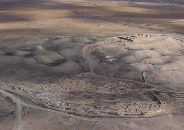
Be honest with yourself about what you can see. Zoara is not a grand ruin with standing columns. Much of the ancient town lies under fields, low mounds, and modern settlement. Many of its finest objects, including tombstones, are kept in museums. The Museum at the Lowest Place on Earth, here in Ghor al-Safi, is the best place to see objects from this area up close.
So much of the experience is the landscape itself. To the west, the Dead Sea shimmers, with white salt crusting its southern edge. To the east, the red and brown mountains climb toward the plateau where Karak Castle stands. Between them lies this narrow, fertile strip. Stand still for a moment and you will hear tractors, birds in the palms, and wind moving across the flat ground.
As you leave, look again at the green fields against the bare hills. That contrast is the whole story of Zoara. People came, and stayed, and returned, because water reached this ground. Pilgrims, farmers, merchants, and families all passed through here. Their names survive on small stones. And the palms are still here, in the same low, warm air.
Key facts
What to look for
Practical tips
Common questions
Is there a free audio guide to Zoara?
Yes — the Lokali app narrates Zoara free of charge in 50+ languages. The guide runs about 6 minutes, covers the history, what to look for on site and practical tips, and works offline once downloaded.
Where is Zoara?
Zoara is near Al-Karak, Jordan, at 31.0469, 35.5025. Tap the map link on this page for directions from where you are.
What is Zoara known for?
Biblical Zoar is traditionally placed at this southern plain. Zoara appears on the sixth century Madaba mosaic map.
What should you look for at Zoara?
Salt crust along the southern edge of the Dead Sea. Irrigation channels carrying water across the flat fields. Date palms echoing those drawn on the Madaba Map.
What should you know before visiting Zoara?
Visit the Museum at the Lowest Place on Earth nearby. Come early morning to avoid the valley's intense heat.
When is the best time to visit Zoara?
Come early morning to avoid the valley's intense heat.
On the map
Opens directions to Zoara from your location.
More to see in Al-Karak


Hear Zoara in your language
The full story, narrated, in 50+ languages. Download it before you go and it plays offline, at your own pace, with no ticket and no tour group.