
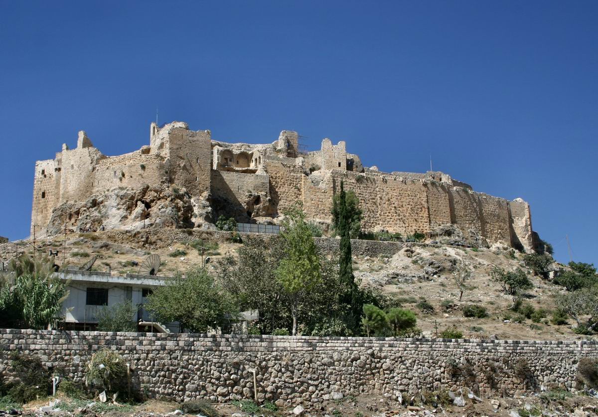
Photo: Shayno · CC BY-SA 3.0 · Wikimedia Commons
Margat is a castle in Syria. A Muslim fortress first stood here in the eleventh century. The free Lokali audio guide runs 6 minutes.
✓ Published October 2026 · how we write these guides
Visitor facts
| Lokali audio guide | 6 min · free |
|---|---|
| Type | Archaeological Site |
| Location | Baniyas, Syria |
| Coordinates | 35.1511, 35.9492 |
| Languages | 50+, in the Lokali app |
The story
Put your hand flat against the wall. The stone is dark and rough, and it holds the heat of the sun long after the air has cooled. This is basalt, a volcanic rock. It gives the whole fortress the colour of old charcoal. Around you, the wind comes up the slope from the sea. It carries dust, wild thyme, and sometimes a faint taste of salt. You are standing on Margat, one of the great castles of the medieval Levant.
Look west first. On a clear day, the Mediterranean is a pale band beyond the coastal plain. The town of Baniyas lies below, near the shore. This is why the castle stands here. From this ridge, a garrison could watch the coast road that ran between north and south. Any army, merchant caravan, or pilgrim band on that road passed under these walls. Control of the hill meant control of the coast.
Local people call the castle Qalaat al-Marqab. In Arabic, that name means something like the castle of the watchtower. It is an honest name. Historical sources say a Muslim fortress first stood here in the eleventh century. That earlier castle was smaller than what you see today. Over the next two centuries, the site changed hands several times. Byzantine forces and then Crusader lords from the Principality of Antioch held it in turn.
The Crusaders called it Margat. For a time, a local noble family called the Mazoir held the castle. Keeping a fortress of this size was very expensive, however. In 1186, the family gave Margat to the Knights Hospitaller. The Hospitallers were a military religious order. They began by caring for sick pilgrims in Jerusalem, and later they became one of the strongest fighting forces in the region. Under their control, Margat grew into the fortress around you.
Here is the first thing most visitors miss. Margat was not only a military base. It was almost a small town. The outer walls once enclosed a large area with houses, storerooms, and cisterns for water. Sources describe a garrison big enough to hold out for years. The knights were only a small part of the people here. Soldiers, servants, craftsmen, and farmers from the surrounding villages lived and worked inside these walls.
Now walk toward the inner citadel at the southern end. The plan of the castle is roughly triangular, because it follows the shape of the hilltop. The strongest defences face south. That is the side where the ground is level enough for an attacking army. Here the builders placed their most powerful structure — a massive round tower, the keep. Round towers were harder to undermine and they turned away stones from siege engines better than square corners.
Notice the stone as you move. Most of it is the local black basalt. In some places, you will see paler stone around doors, windows, and arches. That contrast is not decoration alone. Basalt is very hard and difficult to cut into fine shapes. Masons often used softer, lighter stone where they needed clean edges. The result is a castle with a dark body and light details.
Inside the citadel is the chapel. It is a simple, strong building with pointed arches. That style comes from European Gothic architecture of the period, the style of the great cathedrals of France. Traces of painted plaster survive on some walls. These are the remains of medieval wall paintings of saints and religious scenes. They are faint now. Stand quietly for a moment and let your eyes adjust to the shade. Shapes and colours appear slowly.
Here is a second surprise. In 1188, the Muslim leader Saladin marched along this coast. He captured many Crusader towns and castles that year. Margat was not one of them. The chronicles suggest that he looked at the fortress and judged it too strong to take quickly, so he moved on. For nearly another century, the Hospitallers held this hilltop while the lands around them changed hands.
That ended in 1285. The Mamluk Sultan Qalawun brought an army to the hill. The Mamluks were a powerful dynasty based in Egypt and Syria. His engineers dug tunnels under the southern defences, and part of a tower came down. The defenders understood that the castle was now open to attack. They agreed to surrender. Historical accounts say the knights were allowed to leave with their lives and go to the coast.
The Mamluks did not destroy Margat. They repaired the damaged walls and kept the castle as an important base. If you look closely at the southern defences, you may see places where the masonry changes. These areas are thought to show the Mamluk rebuilding after the siege. One castle, two builders, two different traditions of stonework, standing side by side in the same wall.
As you explore, take care. The ground is uneven, and some passages are dark. Many walls have lost their upper parts over the centuries. Earthquakes, weather, and later stone-robbing have all left marks. Grass and small plants grow from the cracks, and lizards move fast across the warm basalt. In spring, wildflowers fill the open ground between the ruins. In summer, the stone gives off heat like an oven.
Before you leave, go back to a place where you can see the sea. Think of a guard on this wall eight hundred years ago. He watched the same coast and the same light on the water. He heard the same wind. The road below is busier now, and the villages are larger. But the hill is the same hill. As you walk out through the gate, touch the dark stone one more time. It is still warm.
Key facts
What to look for
Practical tips
Common questions
Is there a free audio guide to Margat?
Yes — the Lokali app narrates Margat free of charge in 50+ languages. The guide runs about 6 minutes, covers the history, what to look for on site and practical tips, and works offline once downloaded.
Where is Margat?
Margat is near Baniyas, Syria, at 35.1511, 35.9492. Tap the map link on this page for directions from where you are.
What is Margat known for?
A Muslim fortress first stood here in the eleventh century. The Knights Hospitaller took control of Margat in 1186.
What should you look for at Margat?
Pale stone framing doors against the dark basalt walls. The massive round keep guarding the southern side. Faint traces of medieval wall paintings in the chapel.
What should you know before visiting Margat?
Wear sturdy shoes for uneven ground and dark passages. Bring water and sun protection, as shade is limited.
When is the best time to visit Margat?
Visit in late afternoon for softer light on the basalt.
On the map
Opens directions to Margat from your location.
More to see near Margat

Hear Margat in your language
The full story, narrated, in 50+ languages. Download it before you go and it plays offline, at your own pace, with no ticket and no tour group.