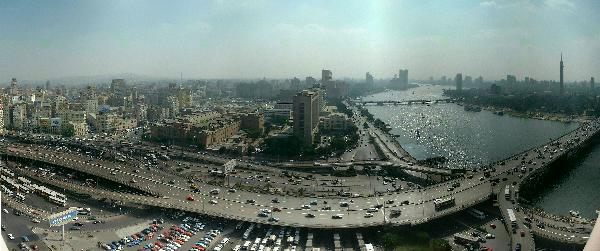
Photo: Wikimedia Commons contributor · CC BY-SA 3.0 · Wikimedia Commons
6th October Bridge is a road bridge. It is near Cairo, Egypt. Named after 6 October 1973, start of October War. The free Lokali audio guide runs 6 minutes.
✓ Published October 2026 · how we write these guides
Visitor facts
| Lokali audio guide | 6 min · free |
|---|---|
| Type | Bridge |
| Location | Cairo, Egypt |
| Coordinates | 30.0492, 31.2286 |
| Languages | 50+, in the Lokali app |
The story
Listen first. Under the hum of engines there is a lower sound, a steady rumble passing through concrete and steel. Horns rise and fall in short bursts. Somewhere below, water moves slowly past the pillars. This is the 6th October Bridge, and for most of the people crossing it right now, it is not a monument at all. It is simply the way home, the way to work, the way across the Nile.
The bridge is an elevated highway that carries traffic from the eastern side of Cairo, over the river, and into the western districts. It does not make one simple leap across the water. Instead it runs above streets and rooftops for a long stretch, rises over the Nile, touches down on Gezira island, and then crosses a second arm of the river. Think of it less as a bridge and more as a raised road through the heart of the city.
The name carries a specific memory. On 6 October 1973, Egyptian forces crossed the Suez Canal at the start of the war that Egyptians call the October War. For Egypt, that crossing became a moment of national pride. The date now appears across the country, on streets, on a whole satellite city west of Cairo, and here, on one of the busiest roads in the capital. Every driver who says the bridge's name is also saying that date.
Here is something many visitors do not expect. This road was not built in one push. Work began before the war that gave it its name, and the structure grew in stages over roughly a quarter of a century. Sections opened one after another as the city around them kept growing. The full route was finished in the 1990s. So the bridge is, in a way, a record of Cairo changing while it was being built.
Why did Cairo need it so badly? Picture a city that grew enormously during the twentieth century. Millions of people live on both sides of a wide river, and the river can only be crossed at certain points. Ground-level streets in the old centre were never designed for that much traffic. The answer was to lift the cars into the air, above the junctions and markets, and send them straight across.
Look at the structure itself. It is mostly reinforced concrete, grey and heavy, set on rows of thick pillars. Near the river, the spans grow longer to leave room for boats underneath. The design is practical, not decorative. There are no towers, no carved lions, no grand arches. Its character comes from scale and repetition, the same shape of pillar marching on, again and again, into the haze.
Now turn toward the water. From the bridge, or from the riverbanks beside it, you can watch feluccas, the traditional wooden sailing boats of the Nile, with their tall, angled sails. Many now carry visitors and families on short evening trips. Larger tour boats glide past too, sometimes strung with coloured lights after dark. The contrast is part of the scene here: an ancient way of moving on the river, under a modern road built for the car.
When the bridge reaches Gezira island, it passes over Zamalek, one of Cairo's leafier neighbourhoods. From above, you may notice trees, sports clubs, embassies, and older apartment buildings with balconies. Not far from the bridge stands the Cairo Tower, a slim lattice-covered tower that rises over the island. The Cairo Opera House complex is also close by. Then the road lifts again over the western channel of the Nile and continues toward the districts of Agouza and Mohandessin.
On the eastern side, the bridge runs close to the downtown area around Tahrir Square and the Egyptian Museum, the older museum with its famous rose-coloured façade. Further along, the road continues in the direction of Ramses, home to the city's main railway station. In just a few minutes of driving, without heavy traffic, you pass from the old colonial-era centre, over an island, and into newer neighbourhoods built for a growing middle class.
That phrase, without heavy traffic, matters. Cairenes have a complicated relationship with this road. At quiet hours it moves fast, and the view of the river opens up beautifully. At rush hour it can slow to a crawl, a long line of taxis, microbuses, private cars, and delivery bikes, all edging forward together. Locals often judge the mood of the whole city by how the bridge is moving.
There is a quieter human side as well. Look for small moments in the traffic: a driver passing a cup of tea through a window, a passenger leaning out for a better view of the water, a microbus conductor calling out destinations. The bridge is not a place for walking, but it is full of people. It is one of the shared spaces where much of Cairo spends part of every day, waiting, talking, and watching the river pass below.
If you want to really see the structure, the best views often come from beside it rather than on top of it. The riverside walkways in Zamalek and along the eastern bank let you look up at the long spans. A felucca trip near sunset shows the bridge from water level, with the concrete turning warm gold and then darkening against the sky. After dark, headlights form two moving rivers of light above the real one.
So take a moment where you are. Feel the vibration, or watch it from the bank. Notice the grey pillars standing in the brown-green water, the sails moving past them, the steady stream of light overhead. This road carries the name of a single day in 1973, but its real story is ordinary and constant: a city of millions, crossing its river, again and again. As you move on, listen for the rumble. It will follow you for a while.
Key facts
What to look for
Practical tips
Common questions
Is there a free audio guide to 6th October Bridge?
Yes — the Lokali app narrates 6th October Bridge free of charge in 50+ languages. The guide runs about 6 minutes, covers the history, what to look for on site and practical tips, and works offline once downloaded.
Where is 6th October Bridge?
6th October Bridge is near Cairo, Egypt, at 30.0492, 31.2286. Tap the map link on this page for directions from where you are.
What is 6th October Bridge known for?
Named after 6 October 1973, start of October War. Built in stages over roughly a quarter century.
What should you look for at 6th October Bridge?
Rows of thick grey concrete pillars standing in the Nile. Longer spans over the river leaving room for boats. Feluccas with tall angled sails passing beneath.
What should you know before visiting 6th October Bridge?
Do not walk on it; it is a highway. Take a felucca at sunset to see it from below.
When is the best time to visit 6th October Bridge?
Avoid crossing by car during weekday rush hours.
On the map
Opens directions to 6th October Bridge from your location.
More to see in Cairo


Hear 6th October Bridge in your language
The full story, narrated, in 50+ languages. Download it before you go and it plays offline, at your own pace, with no ticket and no tour group.