
Doi Inthanon National Park
18.5000° N · 98.6000° E · National Park
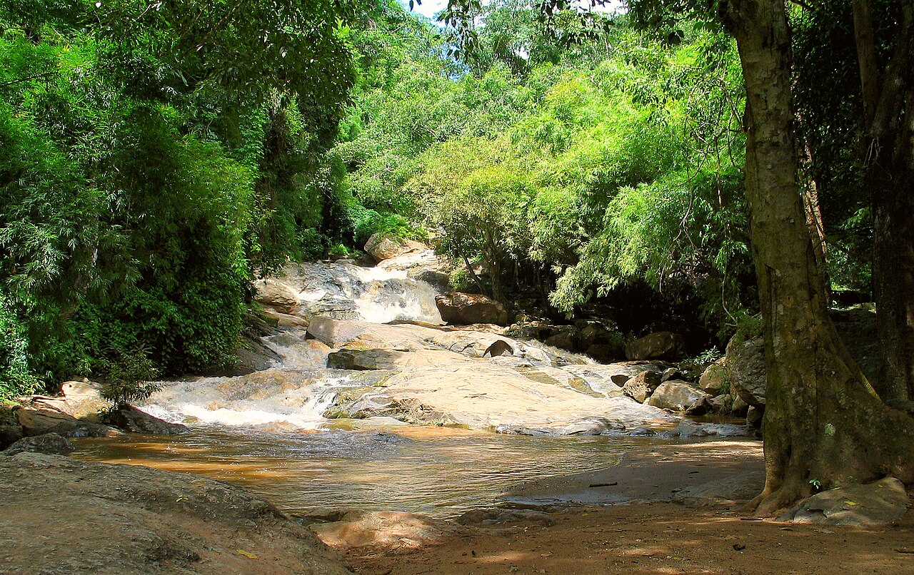
Photo: Vyacheslav Argenberg · CC BY 4.0 · Wikimedia Commons
Doi Inthanon National Park is a national park in Thailand. It is in Chiang Mai, Thailand. Highest mountain in Thailand, about 2,565 metres tall. The free Lokali audio guide runs 7 minutes.
✓ Published October 2026 · how we write these guides
Visitor facts
| Lokali audio guide | 7 min · free |
|---|---|
| Type | National Park |
| Location | Chiang Mai, Thailand |
| Coordinates | 18.5000, 98.6000 |
| Official website | nps.dnp.go.th |
| Languages | 50+, in the Lokali app |
The story
Feel the air first. Down in Chiang Mai, the morning was warm and heavy. Up here, it is cool and damp, and it smells of wet moss and pine. Mist moves between the trees in slow grey sheets. Your breath may even show in front of you. Welcome to Doi Inthanon, the highest mountain in Thailand.
The summit stands at about 2,565 metres above sea level. That number is easy to forget, so think of it this way. You have just driven from a tropical city into a forest that feels closer to the hills of northern Europe. Geographers often describe these ridges as the far southern end of the long mountain chains that run down from the Himalayas. You are standing on their last high step.
The mountain did not always carry this name. Locals once called it Doi Luang, which simply means the big mountain. Another old name was Doi Ang Ka, often translated as the crow's pond, after a small pool near the top. The current name honours King Inthawichayanon, one of the last kings of Chiang Mai. In the nineteenth century, Chiang Mai was the heart of Lanna, an independent northern kingdom with its own script and its own customs.
Here is the first surprise. The king cared so deeply for these forests that he asked for part of his remains to rest on the mountain. After his death, his wish was honoured. Near the summit, a small white chedi, a Thai reliquary monument, holds those remains. Many visitors walk straight past it on the way to the summit sign. Pause there for a moment. It is the reason the whole mountain carries his name.
The summit itself is a quiet moment, not a dramatic one. There is no bare rocky peak with a sweeping view. Instead, the highest point sits inside thick forest, marked by a sign that people queue to photograph. Just beside it starts the Ang Ka Nature Trail, a short wooden boardwalk. It is easy to walk, and it leads you into one of the strangest landscapes in the country.
On the boardwalk, look down. Beneath your feet lies a sphagnum bog, a soft, spongy carpet of moss that holds water like a sponge. Look up, and the tree trunks wear coats of moss, ferns and small orchids. This is cloud forest. It survives because the mountain wraps itself in mist for much of the year. The moisture drips from every branch. Even on a dry day, the wood under your shoes is often wet, so walk carefully.
Now listen. The trees are full of small, quick movements and high calls. Doi Inthanon is one of the most important places for birdwatching in all of Southeast Asia. Hundreds of species have been recorded across the park. Some birds live at these heights and almost nowhere else in Thailand. Early in the morning, birdwatchers stand silently along this trail with long lenses, waiting. If you see them, slow down and lower your voice.
A little below the summit, two tall pagodas rise from the ridge. They were built by the Royal Thai Air Force to honour the sixtieth birthdays of King Bhumibol and Queen Sirikit, in the late 1980s and early 1990s. The king's pagoda is a softer brown and purple tone. The queen's pagoda has a lilac colour. Around them, terraced gardens hold flowers that enjoy the cool climate. On a clear day, the terraces open onto wide views of folded green hills.
Those clear days are not guaranteed, and that is the second surprise. In the cool season, roughly from December into February, temperatures near the top can drop close to freezing. On some nights, a thin frost forms on the grass. Thai people travel from across the country just to feel this cold. Locals have a special name for this rare frost. Seeing a tropical nation pull on woolly hats is part of the charm.
Water is the other great story here. The mountain feeds many streams, and on the drive up you pass several waterfalls. Wachirathan is one of the most powerful, a heavy white curtain that throws spray across the viewing area. Siriphum falls in long, thin ribbons down a dark cliff. In the rainy season the falls roar. In the dry months they grow gentler. Either way, the cool spray on your face is worth the stop.
The mountain is not empty wilderness. People live on its slopes, including Hmong and Karen communities, two of the hill peoples of northern Thailand. In past decades, opium poppies were grown in parts of these highlands. Royal agricultural projects later encouraged farmers to grow other crops instead. Today you may see terraced rice fields, strawberries, coffee, and cool-climate vegetables and flowers. At roadside stalls, families sell fruit, coffee and woven goods.
If you have more time, ask about the Kew Mae Pan Nature Trail. It follows an open ridge with grassland, red rhododendrons in the cool season, and wide views over the valleys. A local guide usually leads walkers here, which supports the nearby communities. The trail closes for part of the year, during the rainy season, so it may not be open on your visit. When it is open, it gives you the mountain views that the summit itself hides.
As you move around the park, notice how the plants change with height. Lower down, the forest is warmer and drier, with broad leaves and bamboo. Higher up, you see pines, then the dripping moss of the cloud forest. In a single morning, you pass through several climate zones. Few places let you feel that change so quickly, simply by following one winding road toward the sky.
Before you leave, stand still for one more minute. Feel the cool air on your skin and listen to the drip of water from the leaves. Somewhere nearby, a bird is calling, and the mist is moving again. Far below, Chiang Mai is warm and loud and busy. Up here, the mountain keeps its own slow time. Take a little of that quiet with you as you head back down.
Key facts
What to look for
Practical tips
Common questions
Is there a free audio guide to Doi Inthanon National Park?
Yes — the Lokali app narrates Doi Inthanon National Park free of charge in 50+ languages. The guide runs about 7 minutes, covers the history, what to look for on site and practical tips, and works offline once downloaded.
Where is Doi Inthanon National Park?
Doi Inthanon National Park is in Chiang Mai, Thailand, at 18.5000, 98.6000. Tap the map link on this page for directions from where you are.
What is Doi Inthanon National Park known for?
Highest mountain in Thailand, about 2,565 metres tall. Named after King Inthawichayanon, a ruler of Chiang Mai.
What should you look for at Doi Inthanon National Park?
Small white chedi holding the king's remains near summit. Spongy sphagnum moss bog beside the Ang Ka boardwalk. Orchids and ferns growing on mossy tree trunks.
What should you know before visiting Doi Inthanon National Park?
Bring a warm jacket even when Chiang Mai feels hot. Arrive early morning for birdsong and clearer summit air.
When is the best time to visit Doi Inthanon National Park?
Check road and trail conditions during the rainy season.
On the map
Opens directions to Doi Inthanon National Park from your location.
More to see in Chiang Mai


Hear Doi Inthanon National Park in your language
The full story, narrated, in 50+ languages. Download it before you go and it plays offline, at your own pace, with no ticket and no tour group.