Doi Suthep-Pui National Park
18.8013° N · 98.8913° E · Park
Doi Suthep-Pui National Park is a park in Chiang Mai, Thailand. Mountain park covering over 260 square kilometres, encompassing Doi Suthep and Doi Pui peaks. Most visitors spend 2–4 hours here. The free Lokali audio guide runs 5 minutes.
✓ Verified August 2026 · how we write these guides
Visitor facts
| Time needed | 2–4 hours |
|---|---|
| Lokali audio guide | 5 min · free |
| Type | Park |
| Best for | Photography |
| Location | Chiang Mai, Thailand |
| Coordinates | 18.8013, 98.8913 |
| Languages | 45, in the Lokali app |
The story
The road climbs. With every turn the air grows cooler and cleaner. Pines and broadleaf trees crowd the slopes. Mist drifts between the trunks even in daytime. Roll down the window and breathe. You have left the warm plain behind and entered the green mountains above Chiang Mai. This is Doi Suthep-Pui National Park.
The park covers two mountains, Doi Suthep and Doi Pui, that rise to the west of the city. Their forests stretch across many ridges and valleys. The highest point reaches about 1,685 meters, high enough that the air stays cool and the light feels soft. Thailand set this land aside as a national park in 1981, to protect the forest and the waters that flow from it.
The mountain takes its name from a hermit. Old accounts tell of a holy man named Sudeva who lived alone on these slopes long ago, in prayer and study. The name Doi Suthep remembers him. Whether the stories are exact, they carry a truth that still fits the place. People have come here to seek quiet and meaning for a very long time.
Near the top of Doi Suthep stands the most visited place in the park, the temple of Wat Phra That Doi Suthep. By tradition it was founded in 1383, in the time of the Lanna kingdom. A long stairway, lined with the curving bodies of serpent guardians, leads up to a golden shrine that catches the sun. From the terrace, on a clear day, the whole city spreads out far below.
A well-loved legend explains why the temple stands here. The story tells that a sacred relic was placed on the back of a white elephant, which was then set free to roam. The elephant climbed this mountain, trumpeted three times, and lay down at this spot. There it died. The people took this as a sign, and built the shrine where it had stopped. It is a legend, told and retold, and part of what draws visitors up the slope.
Higher along the road lies Bhubing Palace, the winter home of the royal family. When the royals are away, its gardens open to visitors. Roses and cool-climate flowers grow here that cannot survive on the hot plain below. Neat paths wind among the beds. The mountain air makes the gardens possible.
Beyond the palace, near the peak of Doi Pui, sits a village of the Hmong people, one of the hill communities of northern Thailand. Here you can learn a little of their way of life, see their handmade cloth and silver work, and walk among gardens cut in steps into the slope. Treat the village as a home, not a display, and it will feel warmer for it.
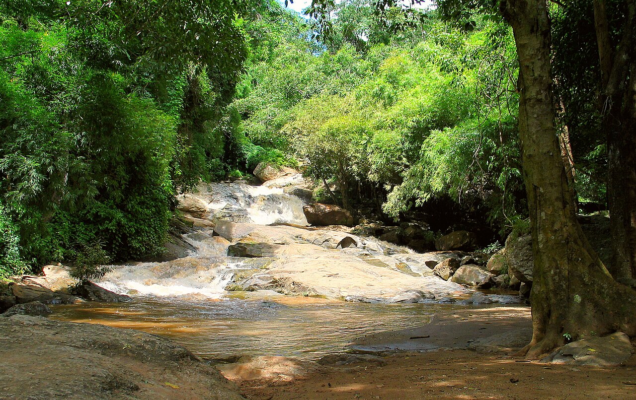
The park holds several waterfalls, fed by the rains that the forest catches. Huay Kaew falls lie near the foot of the mountain, an easy stop close to the city. Others, like Montha Than, ask for a short walk through the trees. The sound of falling water carries before you see it. The pools below are cool and clear.
These forests are alive. Birdsong fills the canopy, and the park is known among those who watch birds for its great variety. Butterflies cross the paths. Ferns and orchids cling to the trees. Walking trails of different lengths let you go as deep into the green as your legs allow. Even a short walk rewards you.
Weather on the mountain changes fast. Sun gives way to cloud, and cloud to a fine drifting mist. The cool is a relief after the heat below, but it can turn damp and chilly. This shifting sky is part of the mountain's character. One moment the city shines below you; the next, the cloud closes in and the world shrinks to the trees nearby.
Many places in the park lie along a single winding road, so it is easy to join several in one trip. Songthaews, the red shared trucks, run up from the city, and many drivers will wait while you visit. Go early if you can. The light is best, and the steps and gardens are calmer before the day fills up.
Mountains have a way of putting a city in its place. From up here, Chiang Mai looks small and gentle, ringed by green. The air is clean. The temple bells ring faint and far. Whatever brought you up the slope, you come down a little lighter, with the cool of the forest still on your skin. The mountain was here long before the city, and it will keep watch over it still.
Key facts
What to look for
Practical tips
Common questions
How long do you need at Doi Suthep-Pui National Park?
Plan 2–4 hours. That is the time most visitors spend at Doi Suthep-Pui National Park. The free Lokali audio guide adds about 5 minutes of narration you can listen to as you walk, so it fits inside your visit rather than adding to it.
Is there a free audio guide to Doi Suthep-Pui National Park?
Yes — the Lokali app narrates Doi Suthep-Pui National Park free of charge in 50+ languages. It covers the history, what to look for on site and practical tips, and it works offline once downloaded.
Where is Doi Suthep-Pui National Park?
Doi Suthep-Pui National Park is in Chiang Mai, Thailand, at 18.8013, 98.8913. Tap the map link on this page for directions from where you are.
What should you know before visiting Doi Suthep-Pui National Park?
Take a red songthaew truck up from the city.
What is Doi Suthep-Pui National Park known for?
The park was established in 1981.
What is the best time to visit Doi Suthep-Pui National Park?
The Monk's Trail descends steeply from Doi Suthep temple to the city—a 3-hour hike that locals favour.
On the map
Opens directions to Doi Suthep-Pui National Park from your location.
Reference
More to see in Chiang Mai




Hear Doi Suthep-Pui National Park in your language
The full story, narrated, in 50+ languages. Download it before you go and it plays offline, at your own pace, with no ticket and no tour group.