
Pythagoreion
37.6900° N · 26.9426° E · Archaeological Site
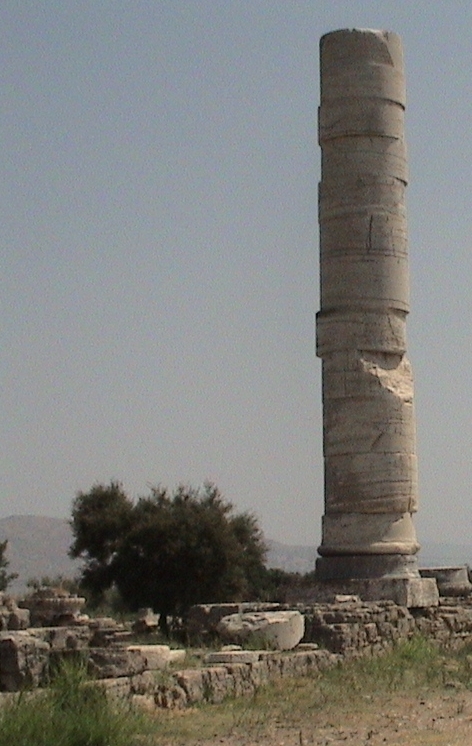
Photo: Christopher Eckert (de:User:Wikipedia ce) · CC BY-SA 3.0 · Wikimedia Commons
Pythagoreion is an ancient fortified port in Samos, Greece. Tunnel of Eupalinos dates to the sixth century BCE. The free Lokali audio guide runs 7 minutes.
✓ Published October 2026 · how we write these guides
Visitor facts
| Lokali audio guide | 7 min · free |
|---|---|
| Type | Archaeological Site |
| Location | East Samos, Greece |
| Coordinates | 37.6900, 26.9426 |
| Languages | 50+, in the Lokali app |
The story
Listen first. Rigging taps against masts in the harbour. Coffee cups clink on marble tables along the quay. Under your feet the paving stones are smooth and warm, and the air smells of salt, grilled fish and pine resin from the hills behind. Across the water, on a clear day, the coast of Turkey shows as a low blue line. This is Pythagoreion, a small harbour town on the south-east coast of Samos. Below its cafés lies one of the most ambitious cities of the ancient Greek world.
Start with the harbour itself, because it is older than it looks. The long stone breakwater that shelters the fishing boats follows the line of an ancient harbour mole. A mole is a man-made sea wall built out into deep water. The Greek historian Herodotus wrote about the works of Samos in the fifth century before the common era. He singled out this harbour wall as one of the greatest engineering feats of the Greeks. The modern breakwater sits on top of that ancient foundation.
The man behind much of this ambition was Polycrates. He ruled Samos as a tyrant in the sixth century before the common era. In ancient Greece, a tyrant simply meant a ruler who took power outside the usual rules, not necessarily a cruel one. Under Polycrates, Samos built a powerful fleet and controlled trade across this part of the Aegean. Wealth flowed in, and it paid for walls, temples, a harbour and something even stranger, hidden inside the mountain above you.
That strange project is the Tunnel of Eupalinos. Look up at the hill to the north-west of town. The ancient city needed fresh water, but the best spring lay on the far side of the mountain. Polycrates did not want an exposed aqueduct that an enemy could cut. So an engineer named Eupalinos, from the city of Megara, cut a channel straight through the rock. The tunnel runs for roughly a kilometre under the mountain.
Here is the detail that still surprises engineers today. The workers did not dig from one end. Two teams started on opposite sides of the mountain and dug towards each other. With no compass and no modern survey tools, they still met in the middle with only a small error. Near the meeting point, the tunnel bends slightly. Scholars believe the teams adjusted their course on purpose, so they would not miss each other in the dark.
If you visit the tunnel, the experience is tight and cool. The passage is narrow, and in places you must stoop. The rock walls still carry the marks of hand tools. Alongside the walkway, a deeper trench held the clay pipes that carried the water to the city. It is a good place to imagine the sound of hammers and the light of oil lamps. Some sections may be closed, so check what is open before you go.
Now turn your attention to the town's name. For centuries, this place was known as Tigani, a Greek word for a frying pan. Locals say the name came from the round shape of the harbour. In 1955, the town was renamed Pythagoreion. The new name honours Pythagoras, the mathematician and philosopher who was born on Samos in the sixth century before the common era. Most people remember him from school, through the theorem about right-angled triangles.
Pythagoras did not stay on Samos for his whole life. Ancient writers say he left the island, and one popular account links his departure to the rule of Polycrates. He later founded a community of followers in southern Italy. That story is told in ancient sources, but many details of his life are uncertain. Even so, the town has claimed him with pride. On the harbour mole you will find a modern statue of Pythagoras, designed around the shape of a triangle.
Walk to the western edge of the harbour and you reach a stone tower and a white church. The tower is known as the Castle of Lykourgos Logothetis. Logothetis was a local leader during the Greek War of Independence in the 1820s, when Greeks rose against Ottoman rule. The fortified tower was built using stones from older ruins. Beside it stands the Church of the Transfiguration, which locals connect with a victory during that war.
Around the castle, the ground opens into an archaeological site. Here you can see foundations, column pieces and the outlines of ancient buildings. Layers of history sit on top of each other — Greek, Roman, early Christian. On the edge of town are the remains of Roman baths, built when Samos was part of the Roman Empire. The town's archaeological museum holds statues, inscriptions and objects found in the area. It is worth an hour if you want faces to put with the ruins.
The ancient city walls are another layer that many visitors miss. Sections of the old defensive wall climb up the slopes above town. They once ran for several kilometres and protected the city from attack. You can still follow parts of them on foot, past gates and tower bases. Higher on the hill sit the scattered remains of an ancient theatre. From up there, the whole harbour spreads out below like a map.
Also on that hillside is the Monastery of Panagia Spiliani. Panagia is a Greek name for the Virgin Mary, and Spiliani means of the cave. The small chapel sits inside a cave in the rock, and the air inside is cool and damp. A few kilometres west of town lies the Heraion, the great sanctuary of the goddess Hera. Together with Pythagoreion, it is listed by UNESCO as a World Heritage Site.
So look around you once more. The boats rock gently on the water. A waiter carries plates along the quay. And somewhere under these streets, under the breakwater and inside the mountain, the work of the ancient Samians is still in place. As you walk away, notice the stones in old walls and doorways. Some of them were cut more than two thousand years ago, and they are still doing a job.
Key facts
What to look for
Practical tips
Common questions
Is there a free audio guide to Pythagoreion?
Yes — the Lokali app narrates Pythagoreion free of charge in 50+ languages. The guide runs about 7 minutes, covers the history, what to look for on site and practical tips, and works offline once downloaded.
Where is Pythagoreion?
Pythagoreion is near East Samos, Greece, at 37.6900, 26.9426. Tap the map link on this page for directions from where you are.
What is Pythagoreion known for?
Tunnel of Eupalinos dates to the sixth century BCE. Two teams dug the tunnel from opposite ends.
What should you look for at Pythagoreion?
Tool marks on the rock walls inside the tunnel. The triangle-shaped Pythagoras statue on the harbour mole. Reused ancient stones in the Logothetis castle tower.
What should you know before visiting Pythagoreion?
Check which tunnel sections are open before you go. Avoid the tunnel if you dislike tight spaces.
When is the best time to visit Pythagoreion?
Walk the hillside walls early before the heat.
On the map
Opens directions to Pythagoreion from your location.
More to see in East Samos



Hear Pythagoreion in your language
The full story, narrated, in 50+ languages. Download it before you go and it plays offline, at your own pace, with no ticket and no tour group.