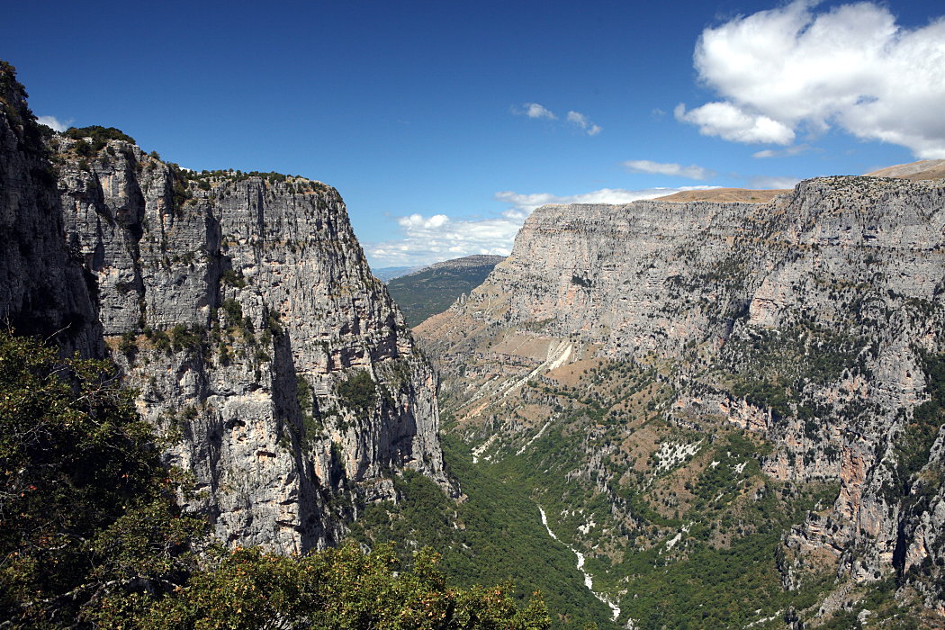
Vikos–Aoös National Park
39.9694° N · 20.7283° E · National Park
Photo: Nikos A. Kanellopoulos · CC BY 3.0 · Wikimedia Commons
Vikos–Aoös National Park is a national park in Greece. Declared a national park in the early 1970s. The free Lokali audio guide runs 7 minutes.
✓ Published October 2026 · how we write these guides
Visitor facts
| Lokali audio guide | 7 min · free |
|---|---|
| Type | National Park |
| Location | Epirus Region, Greece |
| Coordinates | 39.9694, 20.7283 |
| Languages | 50+, in the Lokali app |
The story
Listen first. Somewhere far below, water is moving over stone, a sound so faint it could be wind. The air smells of wild oregano, warm limestone and pine resin. Under your boots, the rock is pale grey and rough, worn smooth only where people have walked for centuries. You are standing on the edge of one of the deepest gorges on Earth. And the river that carved it is still working, quietly, right beneath you.
This is Vikos–Aoös National Park, in the mountains of Epirus, in northwest Greece. Greece declared it a protected area in the early 1970s. It was one of the country's first national parks. The park covers two great river gorges, the Vikos and the Aoös. Between them rises the long limestone wall of Mount Tymfi. Around them sit the stone villages of Zagori. Together they form a landscape where geology and human life have shaped each other for a very long time.
Start with the gorge itself. The Vikos Gorge is famous for one particular measurement. It is not the deepest gorge in the world. But it is extremely deep compared with its width. For that reason, record books have listed it among the deepest gorges of its kind. From the rim, the walls drop away in layers of grey and cream limestone. In places, the far side looks close enough to call across. The depth makes that distance feel enormous.
Now look down to the floor of the gorge. In summer, much of the riverbed can look dry, a pale ribbon of white boulders. This is the Voidomatis River, and much of its water travels underground through the porous limestone. Near the village of Vikos, cold springs push it back to the surface. The water there is famously clear, with a blue-green colour that looks almost unreal. Many visitors are surprised to learn how cold it stays, even in August.
The second gorge belongs to the Aoös River, on the northern side of the park. It feels different. The valley is greener, the slopes are covered in forest, and the river runs fuller. Above both valleys stands Mount Tymfi. Its highest summit, Gamila, rises well above two thousand metres. The mountain's sheer northern faces and pale towers draw climbers and hikers each summer. On clear days, the peaks stand sharp against the sky above the villages.
High on Tymfi lies a small alpine lake called Drakolimni, which means Dragon Lake. Here is a story worth knowing — but it is folklore, not history. Legend has it that a dragon lived in this lake, and another lived in a lake on the neighbouring mountain, Smolikas. The two dragons fought across the valley, hurling rocks and thunderbolts at each other. Locals say the boulders scattered across the slopes are the remains of that battle. The lake is also home to alpine newts, small amphibians that live in its cold water.
Now turn to the people. The forty or so villages of Zagori are built almost entirely of local stone. Walls are grey limestone. Roofs are covered with thick slabs of slate. Houses cluster around small squares, often shaded by a single enormous plane tree. Many of these mansions date from the eighteenth and nineteenth centuries. Some Zagori families made money in trade far from home, then sent it back to build. Their wealth shows in the stone.
The villages are connected by kalderimia. These are old cobbled mule paths, laid by hand, stone by stone. They zigzag down slopes and climb out of ravines. Where a path met a river, local builders raised arched stone bridges. Some have one graceful arch. The best-known, near the village of Kipoi, has three. These bridges were built without modern machinery, and many are still standing. In 2023, UNESCO added the Zagori cultural landscape to its World Heritage List, recognising this blend of nature and human craft.
Here is a detail many visitors miss. Zagori once had a tradition of folk healers, known in Greek as the Vikoi doctors. They were said to gather medicinal plants from the gorge and its slopes. The region's limestone holds an unusual variety of herbs and flowers. Walk slowly and you will notice them: thyme, sage, oregano, and many plants you may not recognise. In late spring, the meadows fill with colour, and the air carries their scent.
The park is also wild in the true sense. Brown bears live in these forests, though they avoid people and are rarely seen. Wolves move through the valleys. Chamois, a kind of mountain goat, climb the cliffs of Tymfi. Eagles and vultures ride the warm air above the gorges. You are more likely to hear a woodpecker or the bell of a shepherd's goat than to meet a large animal. But it is good to know they share this space with you.
Shepherds have been part of this landscape for a very long time. Seasonal herders, including Vlach and Sarakatsani communities, traditionally brought flocks up to the high pastures in summer. Their routes and grazing patterns helped shape the open meadows you see today. In some villages you may still find shepherds' huts, stone sheepfolds, and small chapels on remote ridges. The land is not untouched wilderness. It is a place where people and mountains have lived side by side.
If you have time, choose a viewpoint. At Monodendri, a stone path leads to the small monastery of Agia Paraskevi. It sits right on the edge of the cliff. Beyond it, the view opens straight down into the gorge. From the Oxya viewpoint, or from Beloi on the far side, the whole curve of the canyon spreads below you. Each spot frames the gorge differently. Early morning and late afternoon give the softest light on the limestone.
Now, before you move on, take one more look around. Notice the colour of the rock where the sun hits it. Notice the sound of the river, or the silence where the water runs underground. Look for the slate roofs of the nearest village, and the thin line of a stone path crossing the slope. Everything here was shaped slowly — by water, by weather, by people carrying stones. As you walk away, listen for the river one last time. It is still carving.
Key facts
What to look for
Practical tips
Common questions
Is there a free audio guide to Vikos–Aoös National Park?
Yes — the Lokali app narrates Vikos–Aoös National Park free of charge in 50+ languages. The guide runs about 7 minutes, covers the history, what to look for on site and practical tips, and works offline once downloaded.
Where is Vikos–Aoös National Park?
Vikos–Aoös National Park is near Epirus Region, Greece, at 39.9694, 20.7283. Tap the map link on this page for directions from where you are.
What is Vikos–Aoös National Park known for?
Declared a national park in the early 1970s. Vikos Gorge is exceptionally deep relative to its width.
What should you look for at Vikos–Aoös National Park?
Thick grey slate slabs covering village rooftops. Three-arched stone bridge near the village of Kipoi. Monastery of Agia Paraskevi perched on the cliff edge.
What should you know before visiting Vikos–Aoös National Park?
Visit viewpoints early morning for soft light on limestone. Wear sturdy boots for uneven cobbled mule paths.
When is the best time to visit Vikos–Aoös National Park?
Visit viewpoints early morning for soft light on limestone.
On the map
Opens directions to Vikos–Aoös National Park from your location.
More to see near Vikos–Aoös National Park


Hear Vikos–Aoös National Park in your language
The full story, narrated, in 50+ languages. Download it before you go and it plays offline, at your own pace, with no ticket and no tour group.