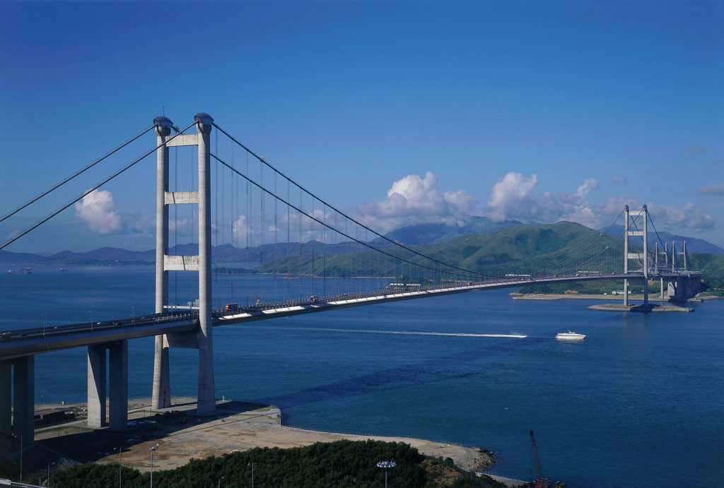
Photo: mageba sa (wahrscheinlich Benutzer:Mageba) · GFDL · Wikimedia Commons
Tsing Ma Bridge is a suspension bridge in Hong Kong. Name combines its two islands, Tsing Yi and Ma Wan. The free Lokali audio guide runs 7 minutes.
✓ Published October 2026 · how we write these guides
Visitor facts
| Lokali audio guide | 7 min · free |
|---|---|
| Type | Bridge |
| Location | Hong Kong, China |
| Coordinates | 22.3514, 114.0742 |
| Languages | 50+, in the Lokali app |
The story
Stand still for a moment and listen. Under the wind, there is a low and steady hum. It comes from traffic high above the water and from trains running somewhere inside the deck. Salt air moves in from the channel. Far below, a container ship slides past, and its wake spreads out slowly. Above you, two pale towers hold up a long, gentle curve of steel. This is the Tsing Ma Bridge, and it carries much of the daily movement between Hong Kong and its airport.
The name is simple once you know the map. The bridge joins two islands, Tsing Yi and Ma Wan. Take the first word of each, and you get Tsing Ma. It is a practical name for a practical structure. The bridge is not a monument built for show. It is a working road and a working railway at the same time. Still, many people who live in Hong Kong see it as one of the clearest images of their modern city.
To understand why it exists, think back to the early 1990s. Hong Kong's old airport, Kai Tak, sat inside the city. Planes came in low over crowded apartment blocks, and the airport had little space to grow. The government chose a new site at Chek Lap Kok, an island next to Lantau, far to the west. But a new airport is useless if people cannot reach it. So a chain of bridges, tunnels and viaducts had to cross the water. This link became known as the Lantau Link, and the Tsing Ma Bridge is its centrepiece.
The bridge opened in 1997, the same year that Hong Kong returned to Chinese sovereignty. The new airport followed in 1998. For the city, these years marked a large change, and the bridge was finished during that moment. Engineers had worked on it through the middle of the decade, building on difficult ground and over a busy shipping channel. Ships could not stop moving while the work went on, so the deck had to rise high above the water.
Now look at the main span — the long stretch between the two towers. It measures about 1,377 metres. When it opened, it was among the longest suspension spans in the world. Here is the detail many visitors miss. It was the longest suspension span anywhere to carry both road traffic and a railway. Trains are heavy and need a very stable track. Building a suspension bridge long enough for ships and strong enough for trains was a serious challenge.
So how does it carry all that weight? A suspension bridge works like a washing line. Two huge main cables run over the tops of the towers and down to heavy anchors on land at each end. From these main cables, smaller vertical cables hang down and hold the deck. The weight of the deck pulls on the cables, and the cables pass that force to the towers and the anchors. The towers themselves rise to roughly two hundred metres. From where you stand, try to follow one main cable from end to end.
The deck has two levels, and this is the second surprise. On the top level, cars, buses and lorries travel on the main expressway. Inside, on the lower level, the trains of the Airport Express and the Tung Chung line run through an enclosed space. If you take the train to the airport, you cross this bridge without seeing much of it at all. Many travellers ride over it every week and never realise they are inside one of the largest bridges in Asia.
The lower level also holds two narrower roads, one on each side of the railway. These lanes have a clear purpose. Hong Kong sits in the path of typhoons, the strong tropical storms of the South China Sea. In very high winds, driving on the open top deck becomes dangerous. When that happens, traffic can move into these sheltered lanes inside the deck. The bridge does not need to close completely, so the link to the airport and to Lantau can stay open in bad weather.
Wind shaped the whole design. The deck has a streamlined shape and openings that let air pass through, which helps the structure stay steady in strong gusts. The bridge also carries a monitoring system. Sensors measure wind, temperature and movement along the structure, and engineers use this data to understand how the bridge behaves. A bridge of this size is never completely still. It moves slightly with heat, with load and with the weather, and it is designed to do so safely.
Turn your eyes to the neighbours. Tsing Ma is only one part of a family of bridges. To the west, past Ma Wan, the Kap Shui Mun Bridge continues the link toward Lantau. It is a cable-stayed bridge, where straight cables run directly from the towers to the deck. Nearby, the Ting Kau Bridge, also cable-stayed, crosses the water toward the New Territories. Together these structures form a group of crossings around the islands. On a clear day, you can compare their shapes from the viewing areas.
The water below has its own life. This channel is an important route for ships moving in and out of the port of Hong Kong, one of the busiest container ports in the world. Watch for tugboats, ferries and long cargo ships stacked with coloured boxes. On Ma Wan, there are older fishing village traces alongside newer housing. On Tsing Yi, the land carries industry, oil facilities and residential towers. The bridge connects these very different places, and you can see the contrast from here.
The light changes the bridge through the day. In the morning, haze can soften the towers until they look almost grey on grey. In the afternoon, the sun moves west and the cables can shine. After dark, lights along the deck and towers trace the curve of the bridge across the water. Each passing train adds a moving line of light inside the structure. It is a calm sight, and many local people come to the viewing platforms in the evening simply to watch.
Before you leave, look at the bridge once more. Think about the people who cross it right now — travellers going home, workers going to the airport, families heading to Lantau for the weekend. Most of them will not look up. For them it is simply the way to get somewhere. Listen again to the hum of traffic and the wind across the water. As you walk away, notice how the long curve of steel stays in view for a surprisingly long time.
Key facts
What to look for
Practical tips
Common questions
Is there a free audio guide to Tsing Ma Bridge?
Yes — the Lokali app narrates Tsing Ma Bridge free of charge in 50+ languages. The guide runs about 7 minutes, covers the history, what to look for on site and practical tips, and works offline once downloaded.
Where is Tsing Ma Bridge?
Tsing Ma Bridge is in Hong Kong, China, at 22.3514, 114.0742. Tap the map link on this page for directions from where you are.
What is Tsing Ma Bridge known for?
Name combines its two islands, Tsing Yi and Ma Wan. Main span measures about 1,377 metres between towers.
What should you look for at Tsing Ma Bridge?
Main cables curving from tower tops to the anchors. Thin vertical hangers lifting the deck from the cables. Container ships passing through the channel far below.
What should you know before visiting Tsing Ma Bridge?
Visit the Lantau Link viewing platform on Tsing Yi island. Come near sunset to see the deck lights switch on.
When is the best time to visit Tsing Ma Bridge?
Check typhoon warnings before planning a visit in summer.
On the map
Opens directions to Tsing Ma Bridge from your location.
More to see in Hong Kong


Hear Tsing Ma Bridge in your language
The full story, narrated, in 50+ languages. Download it before you go and it plays offline, at your own pace, with no ticket and no tour group.